Finding Your Way to and Around the Skagit River System
Where is the Skagit Wild and Scenic River?
The Skagit Wild and Scenic River designation begins just east of the town of Sedro-Woolley, extending to Bacon Creek near the boundary of the Ross Lake National Recreation Area in the North Cascades National Park Service Complex. Segments of the Sauk, Suiattle and Cascade rivers are included in the river system.
How to Get There
A variety of travel routes access the different segments of the Skagit Wild and Scenic River System. Find travel directions below.

The Skagit Wild and Scenic River System includes 158.5 miles of the Skagit River and its tributaries—the Sauk, Cascade, and Suiattle rivers.
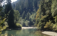
Skagit River
 |
 Visit the Skagit year round and enjoy the river in a number of ways. Popular activities are rafting, fishing, hiking and camping. Winter months bring the bald eagles and a special kind of spirit to the river communities. Visit the Skagit year round and enjoy the river in a number of ways. Popular activities are rafting, fishing, hiking and camping. Winter months bring the bald eagles and a special kind of spirit to the river communities.
The Skagit segment of the Skagit Wild and Scenic River deisgnation begins just east of the town of Sedro-Woolley, at the PUD pipeline crossing. It extends east for 58.5 miles to Bacon Creek near the boundary of the Ross Lake National Recreation Area.
Travel along the scenic North Cascades Highway, State Route 20, between Sedro-Woolley and Newhalem to access the Skagit River segment of the river system. State Route 20 is a seasonal road, closing at MP 171 west of Early Winters from approximately November to April each year (depending on snow and avalanche conditions).
View map of the Skagit River.
Summary of recreation sites: Boatlaunches, Campgrounds, Trails |
Cascade River
 |
 Discover some of the wild essence that the North Cascades has to offer along the Cascade River. Campgrounds at Marble Creek and Mineral Park offer rustic settings to stay overnight during summer months. Discover some of the wild essence that the North Cascades has to offer along the Cascade River. Campgrounds at Marble Creek and Mineral Park offer rustic settings to stay overnight during summer months.
The Cascade segment is 21.8 miles long, from its confluence with the Skagit River near Marblemount east to the forks: the North Fork (1 mile) to the boundary of the North Cascades National Park, and the South Fork to the boundary of the Glacier Peak Wilderness.
At the town of Marblemount cross the Skagit River onto the Cascade River Road and into the Cascade River tributary of the river system. This 23-mile gravel road ends at Cascade Pass Trailhead in North Cascades National Park.
View map of the Cascade River.
Summary of recreation sites: Campgrounds, Trails |
Sauk River
 |
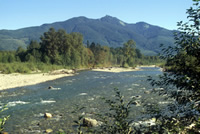 Access the scenic Sauk River from its confluence with the Skagit at Rockport, south to its headwaters near Monte Cristo. Enjoy National Forest recreation sites at Clear Creek, Bedal and farther west along the Mt. Loop Scenic Byway. Access the scenic Sauk River from its confluence with the Skagit at Rockport, south to its headwaters near Monte Cristo. Enjoy National Forest recreation sites at Clear Creek, Bedal and farther west along the Mt. Loop Scenic Byway.
The Sauk segment is 50.8 miles in length, extending from its confluence with the Skagit River near Rockport, south to and including the North Fork to the boundary of the Glacier Peak Wilderness, and the South Fork as far as Elliot Creek.
The confluence of the Sauk and the Skagit Rivers occurs at Rockport along State Route 20. Head south from Rockport on State Route 530 and wind your way along the Sauk River to the town of Darrington where State Route 530 heads west towards State Route 9 and Interstate 5. Continue to access the Sauk River segment south of Darrington on Forest Road 20 to Barlow Pass. Return to Interstate 5 via the Mt. Loop Highway and State Route 92.
View map of the Sauk River.
Summary of recreation sites: Boatlaunches, Campgrounds, Trails |
Suiattle River
 |
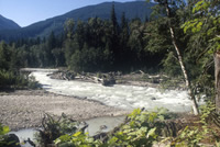 Experience the adventure of swift moving waters along the glacier-fed Suiattle River. Camp here and explore the adjacent Glacier Peak Wilderness, accessible by trail. Experience the adventure of swift moving waters along the glacier-fed Suiattle River. Camp here and explore the adjacent Glacier Peak Wilderness, accessible by trail.
The Suiattle segment is 27.4 miles in length extending from its confluence with the Sauk north of Darrington, east to the boundary of the Glacier Peak Wilderness Area at Milk Creek.
The Suiattle River segment is accessed off State Route 530 south of Rockport and north of Darrington. Follow along the Suiattle River on Forest Road 26 and head to the east. The road ends at access points leading into the Glacier Peak Wilderness.
View map of the Suiattle River.
Summary of recreation sites: Campgrounds |
|