Missouri Water Science Center

MOWSC  Blue River Home   Kansas City, MO    NOAA   contact

Estimated Flood Inundation Maps for the Lower Blue River in Kansas City, Missouri

To provide public access to the information presented in this report, this World Wide Web site was created to display the results of two-dimensional modeling between 63rd Street and Blue Parkway, flood inundation maps, backwater inundation maps, and the latest National Weather Service stage forecast for each forecast location within the study area.

The U.S. Geological Survey, in cooperation with the city of Kansas City, Missouri, began a study in 2003 of the lower Blue River in Kansas City, Missouri, from Gregory Boulevard to the mouth at the Missouri River to determine the extent and character of flood inundation in the Blue River valley from flooding on the lower Blue River and from Missouri River backwater for stages above flood stage.

Project Summary 

How to use these web pages  

How to Interpret the Flood Inundation Maps 

Two-Dimensional Model between 63rd Street and Blue Parkway

Two-Dimensional Model between Hickman Mills Drive and 63rd Street

Estimated flood–inundation mapping for the Lower Blue River in Kansas City, Missouri, 2003–2005, SIR 2005-5089

Estimated flood-inundation mapping for the Upper Blue River, Indian Creek, and Dyke Branch in Kansas City, Missouri, 2006–08, SIR 2008-5068

Get Acrobat Reader Logo and Link   


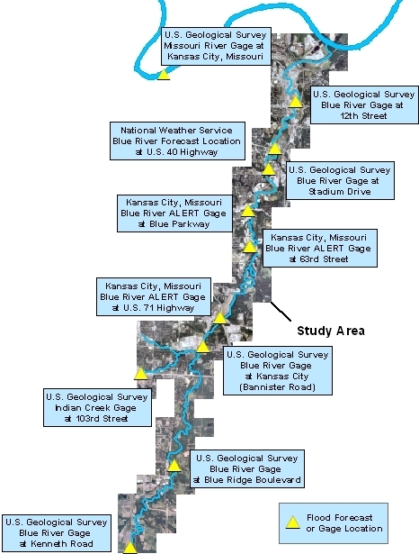
Flood Forecast Locations

Gage locations for the Flood Inundation Maps for the Blue River in Kansas City, Missouri web site Link to USGS Missouri River Gage at Kansas City  Link to USGS Gage Blue River at 12th Street Link to NWS Gage Blue River at 40 Highway Link to USGS Gage Blue River at Stadium Drive Link to Kansas City Alert Gage Blue River at Blue Parkway Kansas City Alert Gage Blue River at 63rd Street Link to Kansas City Alert Gage at Blue River 71 Highway Link to USGS Gage Blue River at Bannister Road Link to USGS Gage  Indian Creek at 103rd Street Link to USGS Gage Blue River at Blue Ridge Boulevard Extension Link to USGS Gage Blue River at Kenneth Road


Base aerial photographs from Jackson County Management Information Systems digital data, 1:833,2003 and City of Kansas City, Missouri, digital data, 1:833, 2004 Universal Transverse Mercator projection Zone 15


Helpful Links:

Kansas City, Missouri

National Weather Service

Kansas City Weather

USGS Real-Time Data for Missouri: Streamflow

Overland Park, Kansas STORMWatch


Flood Forecast Location, Flood Stage, and Current Stage for Study Area


Flood Forecast Location (Click below to link to gage pages) Flood Stage (in Feet) Current Stage (in Feet) Date/Time Universal Time (UTC) (Central Standard Time equals UTC minus 6 hrs) (Daylight Savings Time equals UTC minus 5 hrs) Advanced Hydrologic Prediction Service (Click below to link to National Weather Service pages)
USGS Missouri River Gage at Kansas City, Missouri 32 9.99 11/07/2008 04:45 USGS Missouri River Gage at Kansas City, Missouri
USGS Blue River Gage at 12th Street 30 6.96 11/07/2008 04:45 USGS Blue River Gage at 12th Street
Kansas City, Missouri Blue River ALERT Gage at U.S. 40 Highway 30 Gage Not Reporting 10/28/2008 12:00 Kansas City, Missouri Blue River ALERT Gage at U.S. 40 Highway
USGS Blue River Gage at Stadium Drive 33 7.96 11/07/2008 04:30 USGS Blue River Gage at Stadium Drive
Kansas City, Missouri Blue River ALERT Gage at Blue Parkway 33 Gage Not Reporting 10/28/2008 12:00 Kansas City, Missouri  Blue River ALERT Gage at Blue Parkway
Kansas City, Missouri Blue River ALERT Gage at 63rd Street 48 23.55 11/07/2008 01:35 Kansas City Missouri Blue River ALERT Gage at 63rd Street
Kansas City, Missouri Blue River ALERT Gage at U.S. 71 Highway 61 32.6 10/31/2008 09:06 Kansas City, Missouri Blue River ALERT Gage at U.S. 71 Highway
USGS Blue River Gage at Kansas City (Bannister Road) 34 5.68 11/07/2008 04:45 USGS Blue River Gage at Kansas City (Bannister Road)
USGS Indian Creek Gage at 103rd Street   83.34 11/06/2008 23:30 USGS Indian Creek Gage at 103rd Street
USGS Blue River Gage at Blue Ridge Boulevard 35 25.68 11/07/2008 04:00 USGS Blue River Gage at Blue Ridge Boulevard Extension
USGS Blue River Gage at Kenneth Road   6.39 11/06/2008 22:30 USGS Blue River Gage at Kenneth Road

USGS Home Water Resources Biology Geography Geology Geospatial

Accessibility FOIA Privacy Policies and Notices

Take Pride in America logo USA.gov logo U.S. Department of the Interior | U.S. Geological Survey
URL: http://mo.water.usgs.gov/indep/kelly/blueriver/index.html
Page Contact Information: webmaster-mo@usgs.gov
Page Last Modified: Thursday, 19-Jun-2008 11:44:26 EDT