|
+ Play
Audio
|
+ Download Audio | +
Email to a friend | +
Join mailing list
Dec.
28, 2007: Earlier this year, NASA researcher Dan
Irwin stepped off a plane in Guatemala and found, to his surprise,
that he was running for mayor. It seems the people of San
Andres had put his name on the ballot.
Irwin
respectfully declined, but he was touched. If you ask him
why the residents of rural San Andres are crazy about him,
Irwin, a humble soul, shrugs his shoulders and says, "Everyone
has a hobby. Mine is building things – helping develop their
community. I enjoy it."
 Irwin
is a pioneer of SERVIR (Spanish for "to serve"),
a high-tech satellite visualization system that monitors the
environment of Central America. It helps track and combat
wildfire, improves land use and agricultural practices, and
helps local officials respond faster to natural disasters. Irwin
is a pioneer of SERVIR (Spanish for "to serve"),
a high-tech satellite visualization system that monitors the
environment of Central America. It helps track and combat
wildfire, improves land use and agricultural practices, and
helps local officials respond faster to natural disasters.
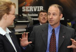
Right:
During a recent visit to Central America, Dan Irwin explains
the inner workings of SERVIR to NASA Deputy Administrator
Shana Dale. [more]
Developing SERVIR was a full-time job for
Alabama-resident Irwin, including many months on assignment
in Central America. What do you do in your spare time so far
from home? With the help of community residents, Irwin built
a playground and a library in San Andres. "I worked on
the projects before and after work and on weekends,"
says Irwin, "just as other people spend time on their
hobbies at those times."
But
it is Irwin's "real" work with SERVIR that makes contributions
reaching far beyond the community level to the whole of Central
America.
"SERVIR
has brought together a lot of different people from a lot
of different backgrounds to create the kind of team needed
to help solve very complex issues and provide potentially
life-saving solutions to local decision makers and stakeholders,"
says John Horack of NASA's Marshall Space Flight Center (MSFC)
where SERVIR technology is developed and tested.
SERVIR's
supercomputer at the Water Center for the Humid Tropics of
Latin America and the Caribbean (CATHALAC) in Panama City
integrates data from a variety of sources and displays a real-time
map of crisis points. At a glance, decisions-makers can see
where rain will fall, where flooding will occur, the location
of forest fires, hurricanes, tornadoes – pretty much anything
nature can dish out. CATHALAC then warns residents.
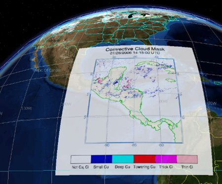
Above:
SERVIR brings high-tech satellite imagery and visualization
tools to bear on Central America. Current maps of fire, floods
and severe weather may be found on the bilingual SERVIR web
site: http://servir.net.
SERVIR also takes a global approach to environmental
challenges by supporting the ten-year plan for implementation
of the Global Earth Observation System of Systems, or GEOSS,
which was adopted by the European Commission and over 70 governments
worldwide.
GEOSS's
main purpose is to foster cooperation and integration among
countries by pooling Earth observation tools and data for
the benefit of all. Because of SERVIR's positive impact in
Central America, GEOSS recently adopted SERVIR as their template--a
sort of "poster child" for how to meet GEOSS goals.
At the organization's recent Ministerial Summit in Cape Town,
South Africa, which was attended by over 70 nations and over
50 international organizations, SERVIR was recognized as a
"GEOSS Early Achievement."
What's
the secret to SERVIR's success? It's not "what"
but "who" – namely, Irwin and what he calls the
"dream team."
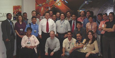
Above: The SERVIR "dream team."
[Larger image]
These
behind-the-scene "wizards" include administrators,
scientists, and technicians like, at CATHALAC, Director Emilio
Sempris, Emil Cherrington, and Francisco Delgado; and, at
NASA's Marshall Space Flight Center, Burgess Howell, Robert
Griffin, and Jason Arnold.
The
CATHALAC team members are in charge of day-to-day on-site
operations: gathering and processing the satellite data, combining
it with ground observations, and getting the results quickly
into the hands of national environmental management and disaster
response leaders. Team members at the MSFC test-bed facility
view SERVIR data at the same time as their Central American
counterparts view it and play key roles in supporting and
coordinating SERVIR projects.
"I'm
involved at several different levels within SERVIR,"
says team member Griffin. "I help coordinate among institutions
in a country as well as with SERVIR and its partners in the
U.S. and abroad. As with everyone involved with these projects,
I help create products to solve problems in the event of a
natural disaster."
 All
of the SERVIR team members will help achieve the next important
step -- geographic expansion. NASA is extending SERVIR's life-saving
benefits to Africa and the Caribbean. SERVIR’s flexibility
and adaptability make it perfect for meeting the new challenges
of these geographic areas, helping NASA and its partners bring
global technology to the grass roots level. All
of the SERVIR team members will help achieve the next important
step -- geographic expansion. NASA is extending SERVIR's life-saving
benefits to Africa and the Caribbean. SERVIR’s flexibility
and adaptability make it perfect for meeting the new challenges
of these geographic areas, helping NASA and its partners bring
global technology to the grass roots level.
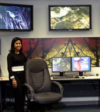
Right:
A SERVIR "test bed node" at the National Space Science
and Technology Center in Huntsville, AL. [Larger
image]
"This
is an extremely exciting time to be a part of this project,"
says Griffin. "Right now, I'm working to deploy SERVIR
in the Dominican Republic. Most recently we brought together
radar imagery and other information to help the Dominican
Republic's government respond to extensive flooding in the
wake of Tropical Storm Noel."
Says
Irwin of Griffin and other members of the team, "all
of these people are indispensable to all that we've done and
will continue to do. Without them, it would be impossible."
It's
no wonder that Irwin reveres the SERVIR team, and that many
Central Americans revere Dan Irwin.
"VOTO PARA DANIEL"
SEND
THIS STORY TO A FRIEND
Author: Dauna Coulter | Production Editor:
Dr. Tony Phillips | Credit: Science@NASA
| more
information |
| SERVIR
-- Regional Visualization & Monitoring System home
page
CATHALAC
-- the Water Center for the Humid Tropics of Latin America
and the Caribbean is the operational institution for
SERVIR.
NSSTC
-- the National Space Science and Technology Center
in Huntsville, Alabama, serves as a "test bed"
and rapid prototyping facility for SERVIR.
Floods!
Fire! SERVIR! -- (Science@NASA)
Serving
Earth -- (Science@NASA) A thousand years ago, Mayan
civilization collapsed. Today, a Space Age "situation
room" in Panama is helping Central Americans avoid
mistakes that doomed the Maya.
The
Rise and Fall of the Mayan Empire -- (Science@NASA)
Scientists are using space satellites to unravel one
of the great mysteries of the ancient world.
Mesoamerica
Burning -- (Science@NASA) The rich diversity of
wildlife in southern Mexico and Central America is in
peril. Local governments are using satellites to get
a grip on a vast
corridor of protected lands.
NASA's
Future: The
Vision for Space Exploration |
|