   |
||||
|
|
||||
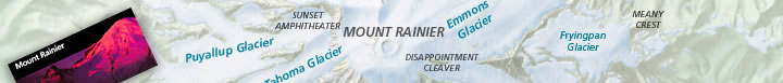
National Trails System Map & Guide |
||||
These maps reflect the most recent map modification date as printed in this brochure's current edition. |
National Trails System MapAdobe Acrobat
PDF » Adobe
Illustrator » JPEG
Shaded Relief » |
IN DEPTH:Data Sources & Accuracy Statement » Map Symbols & Patterns for NPS Maps » Production Tips for NPS Maps »
DOWNLOAD HELP:
|
||
| Top of Page | Previous Page | Home | ||||