Tending the Commons: Folklife and Landscape in Southern West Virginia

Interactive Maps

Features Along Route 3: Rock Creek

A map showing places of interest along Dry Creek in southern West Virginia.

The Shovel Cut Friendly View Arnett Coal River Mountain Coal River Mountain Coal River Mountain Coal River Mountain Coal River Mountain Coal River Mountain Coal River Mountain Coal River Mountain Coal River Mountain Coal River Mountain Coal River Mountain Coal River Mountain Coal River Mountain Coal River Mountain Coal River Mountain Coal River Mountain Coal River Mountain Sandlick Creek Sandlick Creek Sandlick Creek Sandlick Creek Dry Creek Dry Creek Rock Creek Rock Creek Rock Creek Rock Creek Rock Creek Rock Creek Rock Creek Rock Creek Rock Creek Rock Creek Righthand Fork (Rock Creek) Righthand Fork (Rock Creek) Righthand Fork (Rock Creek) Lefthand (Buffalo) Fork Lefthand (Buffalo) Fork Lefthand (Buffalo) Fork Lefthand (Buffalo) Fork Lefthand (Buffalo) Fork Lefthand (Buffalo) Fork Workman Creek Workman Creek Stockingleg Fork Stockingleg Fork Stockingleg Fork Stockingleg Fork Stockingleg Fork Clay's Branch Clay's Branch Sturgeon Fork Sturgeon Fork Lower Briar Hollow Lower Briar Hollow Lower Briar Hollow Flat Hollow Flat Hollow Cantley Hollow Cantley Hollow Bob Williams Hollow Bob Williams Hollow Bob Williams Hollow John Rorrer Hollow John Rorrer Hollow John Rorrer Hollow Squirrel Hollow Squirrel Hollow Hollow Field Hollow Field Cow Hollow Cow Hollow Sugar Camp Hollow Sugar Camp Hollow Sugar Camp Hollow Sycamore Hollow Sycamore Hollow Apple Orchard Hollow Apple Orchard Hollow Apple Orchard Hollow Bob Price Hollow Bob Price Hollow Bob Price Hollow Ann Hollow Ann Hollow Lick Hollow Lick Hollow Crabtree Hollow Crabtree Hollow Bear Den Hollow Bear Den Hollow Cool Spring Hollow Cool Spring Hollow Cool Spring Hollow Salt Log Hollow Salt Log Hollow Broad Hollow Broad Hollow Julie Hollow Julie Hollow Canterbury Hollow Canterbury Hollow Canterbury Hollow Canterbury Hollow

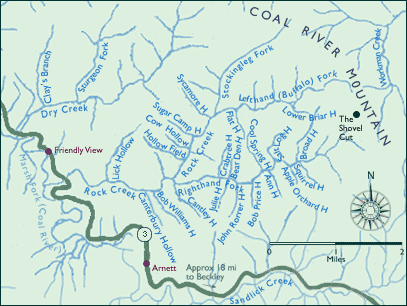
The maps for this site are based on U.S.G.S. topographic quads and were notated in field interviews conducted between 1994 and 1999. Dave Bailey, Woody Boggs, Ben Burnside, Ed Cantley, Tony Dickens, Paul Fitzwater, Ivan Jarrell, Ricky Meadows, Howard Miller, Elbert Pettry, Wesley Scarbrough, and Rocky Turner helped fill out the quads with local names, and their accounts of places and origins of names may be heard by clicking on a number of the creeks with side hollows. Ben Burnside, Woody Boggs, and Ricky Meadows provided supplementary sketches as well. Tom Suzuki transformed the sketches and the annotated quads into these maps, which were modified (10/2000) for navigational purposes.

 Top