 NCDC / Climate Mon. /
Climate-2007 / May / U.S. Drought / Help NCDC / Climate Mon. /
Climate-2007 / May / U.S. Drought / Help
Climate of 2007 - May
U.S. Drought Watch
National Climatic Data Center, 14 June 2007
|
Global Analysis /
Global Hazards /
United States /
Extremes
Use these links to access detailed analyses of Global and U.S. data.
|
Contents Of This Report:
|

|

 National Overview National Overview
|
- Based on the Palmer Drought Index,
severe to extreme drought affected about 24 percent of the contiguous United States as of the end of May 2007, an increase of about 5 percent compared to last month.
By contrast, about 11 percent of the contiguous U.S. fell in the severely to extremely wet categories.
- About 37 percent of the contiguous U.S. fell in the
moderate to extreme drought categories (based on the Palmer Drought Index) at the end of May .
- On a broad scale, the previous two decades (1980s and 1990s) were characterized by unusual wetness with short periods of extensive droughts, whereas the 1930s and 1950s were characterized by prolonged periods of extensive droughts with little wetness (
moderate to extreme drought,
severe to extreme drought).
|
- A file containing the national monthly percent area severely dry and wet from 1900 to present is available for the severe to extreme and moderate to extreme categories.
- Historical temperature, precipitation, and Palmer drought data from 1895 to present for climate divisions, states, and regions in the contiguous U.S. are available at the Climate Division: Temperature-Precipitation-Drought Data page in files having names that start with "drd964x" and ending with "txt" (without the quotes).
|
Detailed Drought Discussion
|
At the end of May, severe to extreme drought was concentrated in the Southeast, Southwest, western High Plains, and extreme northwestern Great Lakes. Drought and abnormal dryness covered a broad swath from the Southwest through the northwestern Plains into the Upper Midwest, as well as another area across most of the Southeast (May 29 U.S. Drought Monitor). Extreme short-term dryness during May across much of the country east of the Mississippi River contributed to worsening drought conditions with dryness and drought expanding into the Ohio Valley. Abnormally dry May weather in the West contributed to worsening conditions across California, Nevada, and eastern Oregon (May 29 vs. May 1 U.S. Drought Monitor). Conditions deteriorated across the Hawaiian Islands but improved across Montana and the Dakotas.
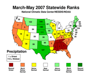
For the Southeast region, the last 6 months have been persistently dry. In fact, December-May has been drier than average for 7 of the last 9 years. Several states had the driest December-May (Mississippi) or March-May (Alabama, Georgia, Mississippi, Tennessee) in their 113-year record.

Several stations in the Southeast reported record low May and spring rainfall. The lowest reports included: Macon, GA with only a trace of rain during May; Tuscaloosa, AL at 0.06 inch; and Anniston, AL with 0.14 inch. Tallahasse, FL had only 2.24 inches for March-May, compared to a spring normal of 15.01 inches, and surpassing the previous record of 3.35 inches set in 1925.
The West region had its 6th driest spring (March-May) on record, but its driest June-May. This is in sharp contrast to the unusual wetness of the last two such 12-month periods, and marks a return to the dryness of the previous 6 years.

|
|
The May precipitation pattern at the primary stations in Alaska was mixed. In Hawaii, dryness continued throughout most the State. The pattern for spring (March-May) was similar to that for May for both Alaska and Hawaii. In Puerto Rico, the month was predominantly dry along the southern and eastern sections but wet in the northwest (based on National Weather Service radar estimates of precipitation), similar to the pattern for the year-to-date.

The drought was reflected in several indicators, including: low soil moisture (modeled and observed), streamflow (modeled and observed), and snowpacks, stressed vegetation, numerous large wildfires (May 1, 10, 20, 31,), and deteriorating pastures. As of May 20, 96% of the pastures were in poor to very poor condition in California and, in Georgia, at 79% poor to very poor, pasture conditions were the lowest of the last 12 years.
As summarized by the Drought Impacts Reporter, the drought has stressed crops in Alabama and delayed crop planting in other states. With ponds and lakes shrinking and wells going dry, watering restrictions and burn bans are in place in many Southeast communities. A state of emergency declared by Georgia Governor Purdue has been extended through June 30. In Florida, 24 counties have been declared disaster areas due to drought conditions and the February freeze, and 41 Alabama counties were declared agricultural disaster areas. Drought warnings were in effect for 37 Alabama counties. By the end of the month, Lake Okeechobee's level fell to 8.94 feet, breaking the record low of 8.97 feet set back in May 2001. In the West, parts of California were declared natural disaster areas due to drought since October 2006, and a local drought disaster was declared in eastern Oregon.
|
State/Regional/National Moisture Status
|
Pre-Instrumental Perspective
|
|
There is no May 2007 Paleoclimatic Perspective
|
Drought Indicators
|
The following indicators illustrate the drought conditions this month:
- Palmer Drought Indices,
- Standardized Precipitation Index,
- long-term (36 to 60 month) percent of normal precipitation maps,
- airport station percent of normal precipitation maps,
- statewide precipitation rank maps,
- Cooperative station percent of normal precipitation maps,
- percent of average maps for the SNOTEL stations in the western mountains provided by the Western Regional Climate Center
- snow course snowpack observations in the western mountains provided by the USDA NRCS,
- satellite-based observations of vegetative health,
- National Weather Service model calculations of
- National Weather Service model calculations of soil moisture using the Leaky Bucket Model,
- Midwest Regional Climate Center model calculations of soil moisture,
- topsoil moisture conditions observed by the USDA and mapped by the Climate Prediction Center,
- pasture and range land conditions observed by the USDA and mapped by the Climate Prediction Center,
- streamflow maps maintained by the USGS.
|
Additional Contacts:
|
- For all climate questions other than questions concerning this report, please contact the National Climatic Data Center's Climate Services Division:
Climate Services Division
NOAA/National Climatic Data Center
151 Patton Avenue
Asheville, NC 28801-5001
fax: 828-271-4876
phone: 828-271-4800
email: ncdc.info@noaa.gov
- For further information on the historical climate perspective presented in this report, contact:
Richard Heim
NOAA/National Climatic Data Center
151 Patton Avenue
Asheville, NC 28801-5001
fax: 828-271-4328
email: Richard.Heim@noaa.gov
-or-
Jay Lawrimore
NOAA/National Climatic Data Center
151 Patton Avenue
Asheville, NC 28801-5001
fax: 828-271-4328
email: Jay.Lawrimore@noaa.gov
|
NCDC / Climate Mon. /
Climate-2007 / May / U.S. Drought / Help
|


