Where You Live

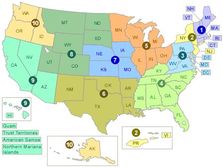
Emergency management activities are coordinated between local organizations (including local fire departments), the ten EPA regional offices, and EPA headquarters in Washington, D.C. To learn about emergency management and responses in your region, click within appropriate area of the map, or choose your state in the pull-down menu below and select "Go."
Contact State and Local Environmental Agencies
- Local Emergency Planning Committees (LEPCs)
- State Emergency Response Commissions (SERCs)
- State Environmental Agencies
Contact U.S. EPA
Learn More About Where You Live
Cleanups in My Community
Find sites where pollution is being or has been cleaned up throughout the United States.
Envirofacts Warehouse
Access several EPA databases with information about environmental activities that may affect air, water, and land anywhere in the United States.
EPA On-Scene Coordinator (OSC) Web Site
Find site-specific information on emergency response and removal actions in each of the ten EPA regions.
Federal Reading Rooms
Review Risk Management Plan (RMP) information at federal reading rooms.
National Response Center (NRC) Spill Data
Search NRC data for information on reported oil and chemical spills.
Toxic Release Inventory (TRI)
Search information on toxic chemical releases and other waste management activities reported annually by certain covered industry groups as well as federal facilities.
Vulnerable Zone Indicator System (VZIS)
Find out if an address of interest to you – your home, place of work, or your child's school - could be affected by a chemical accident.
Window to my Environment
Enter your zip code to access a wide range of environmental data for an area.