Jan 4, 2007
Palouse Heavy Snow Event of January
4, 2007

On the afternoon of January 4th,
2007, a small-scale snowstorm moved over the Palouse. There were 2 interesting
features about this storm that make it noteworthy. The first was the scale of
the storm, which was largely isolated to the Washington and Idaho Palouse region.
The second aspect was the significant impact it made to travel on the Palouse
highways.
A loop of the Spokane radar shows
the relatively small size of this snow storm.

Snow began in Pullman (KPUW) around
1230 pm PST (2030 UTC) and continued for about 4 hours. Spotter reports from
the region show that this area of snow was rather intense, with a few sites
picking up over 4" in a short time.

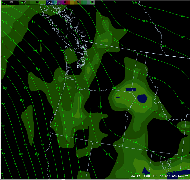
Examination of the typical 500mb
(~18,000 ft) height and vorticity from the GFS initialized at 1200 UTC that
morning shows a fairly vigorous short wave in Montana and North Dakota which
had moved through Washington the previous day. In its wake the atmosphere was
rather unstable (see more on this below). A broader trough was located to the
west of the area with several embedded vorticity centers. By 0000 UTC (4pm PST),
there is an obvious but small vorticity center that has moved into eastern Washington
and intensified. Still, tracking this feature is somewhat difficult. Examination
of the 300mb (~30,000 ft) height and vorticity (not shown) was even less definitive
with this feature. This is somewhat unusual, since these waves are typically
more intense at higher levels in the atmosphere.

Looking at the height and vorticity
at 700mb (~10,000 ft) was rather surprising. The vorticity max moving through
the area was very obvious and intensifying as it moved east. Thus, the main
dynamic forcing for this storm was in the lower to mid-troposphere, which is
lower than for most storms. This, coupled with the instability, had important
ramifications (see below).

Both the NAM/WRF and the GFS models
had indicated the potential for precipitation over southeast Washington, but
were focused more on the evening (after 00Z) hours. But the GFS had been increasing
the speed of this feature over the last few runs. Below is the dprog/dt for
the NAM/WRF model for the precipitation valid for the evening of the 4th (00Z-06Z
5 Jan). This loop shows how the last 3 runs of the WRF model (initialized at
Jan 3 12Z, Jan 4 00Z, and Jan 4 12Z) were all forecasting precipitation, but
there wasn't a great deal of consistency.
The next loop is similar to the previous
one. However, this is the GFS model and is valid for the afternoon (18Z-00Z)
of the 4th of January. The first frame of the loop shows that the earlier runs
of the GFS had the precipitation out in the Columbia Basin, but subsequent runs
had been increasing the speed of this feature, moving into the Palouse. Note
that even the precipitation has a somewhat comma-shape to it. Total precipitation
amounts from the GFS were around 0.25" of liquid, which agreed well with
the ASOS observations at Pullman.

The previously mentioned, the atmosphere
was rather unstable in the wake of the previous day's storm. The image below
is the forecast sounding for Pullman from the GFS valid at 00Z (4 pm PST). A
few things are evident. The sounding was very unstable. Lapse rates between
900mb and 500mb were 6-7 C/km, which is essentially moist adiabatic. The omega
(thin white line) was very strong (-20 mb/s) in the low levels, with a max aoudn
750 mb. Note that this is nearly coincident with the dendritic layer (yellow
portion of the sounding). This pointed to the possibility of convective snow
with heavy snow rates. Another interesting fact is that the convective schemes from both the WRF and GFS turned on at the very start of the event, but then all of the model-generated precipitation thereafter was from the stable scheme.

The Washington State Patrol report
literally hundreds of accidents from this event. Highway 195 (Spokane to Pullman
and Lewiston) and Highway 95 (Coeur d'Alene to Lewiston) were both closed for
a short time. State Highway 26 west of Colfax was closed for 3 hours due to
accidents. While the accumulation of 4-8" of snow in a short period was
a major, the roads were also reported to be icy, not snow packed.
Air temperatures during this event
were 32F at the Pullman airport. Other mesonet observations on the Palouse showed
air temperatures 32-34F during the event. Since this event took place during
the afternoon, it was somewhat surprising to see such icy road conditions given
these temperatures.
Recent Washington DOT road sensors
now allow us to observe the temperatures of the actual road surface. Two such
sensors exist on the Palouse. Spangle is located about 10 miles south of Spokane
at the north end of the Palouse, and the Uniontown observation is located between
Pullman and Lewiston at the south end of the Palouse. Alpowa Summit sensor was
also in the area, just south of the Snake River.


As you can see from the graphs above,
pavement temperatures at all sites were around 28F in the morning, but warmed
to around 40F at the start of the snow event. Skies were actually mostly sunny
in the morning allowing for good radiational warming of the road surfaces. Thus,
as the snow began to fall, it initially melted on the roads. But note the sharp
drop in pavement temperatures during the early afternoon. This drop is likely
due to three causes:
- Decreasing solar angle. While
sunset at this time is shortly after 4pm PST, the road sensors on days before
and after this event showed a peak temperature around 2pm.
- Increasing clouds. The sunny skies
of the morning gave way to cloudy skies by noon as the storm moved in from
the west. This thick cloud deck diminished the incoming solar radiation reaching
the roads.
- Melting. As the cold snow contacted
the warm roads, the heat flux required to melt the snow would have taken heat
out of the pavement, thus cooling it.
The result was pavement temperatures
cooling to the freezing mark as the event progressed. Thus the initially
melted snow later froze to the roads, creating the icy conditions, even during
the daytime hours with air temperatures around 32F. It should be noted that
none of the 3 road sensors were located in the area of the heaviest snowfall,
and in fact were largely on the fringe of the precipitation (see map above).
Thus it is likely that in the area with the intense snow, pavement cooling was
more rapid than what is seen in these sensors.
Thus, one of the most important aspects of this event was the timing. If the short wave arrived about 12 hours earlier or later (i.e., during the late night or early morning hours), the road conditions would have been markedly different. Road temperatures would have been well below freezing during these hours, so the snow would have just accumulated on the roads rather than melting and then freezing.
|


