


|
Print Page | ||||||||
| San Miguel Watershed Coalition | |||||||||
|
Setting
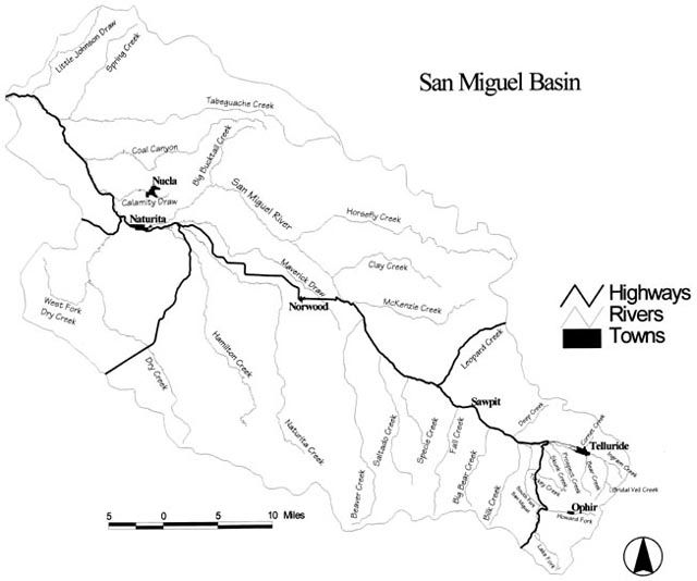
With over 60% of the one million acre watershed in Federal public lands, the San Miguel Watershed in southwestern Colorado includes some of the highest, most beautiful and most biologically intact and valuable landscapes in the nation. At its heart, the predominately free-flowing San Miguel River extends 72 miles from high alpine meadows and waterfalls above Telluride to a deep red sandstone canyon confluence with the Dolores River. The watershed is also home to several independent and culturally diverse small towns with economies variously based on agriculture, mining, resort tourism, and recreation. San Miguel Watershed Map (43k) - Courtesy of the Telluride Institute A coordinated focus on the San Miguel River began in 1990 with a group called the San Miguel River Coalition. This group, formed to address river corridor issues, consisted of the US Forest Service, Bureau of Land Management, Colorado Division of Wildlife, Telluride Institute, Town of Telluride, San Miguel County, The Nature Conservancy, Telluride Visitor Services, commercial river outfitters, and others. The idea of expanding into a watershed approach had its early origins in 1993, as a result of a major conference on water issues developed by the Telluride Institute. This multi-day event led to a newspaper supplement and a strong desire by many participants to continue discussions. Dialogues, research and information gathering began at that conference and soon a network of interested people and organizations was established, first focusing mostly on upper San Miguel basin issues and resources. Over the course of the next several meetings and discussions, it was felt that it was important to extend planning efforts to include the lower San Miguel basin. The National Park Service (NPS), through its Rivers, Trails, and Conservation Assistance Program became involved in the process in 1994. Jointly, the NPS and the Telluride Institute agreed to act as facilitators in a community planning process that would result in a watershed-wide action plan. The Coalition's Goal As stewards of some of the world's highest, wildest and most beautiful lands, the San Miguel watershed Coalition will develop, through a process of collaborative planning and substantive public involvement, a watershed management plan which conserves and enhances the natural, cultural, recreational, social and economic vitality of our communities. The Coalition will guide the plan's implementation and address ongoing issues in the watershed. The Coalition and Its Vision The Coalition contains citizens from all parts of the basin who share a passion for this extraordinary place. Recognizing the need to be inclusive, the fact is that all citizens of the basin are considered to belong to the coalition. In spite of some historic and ongoing differences, we agree on a vision of a watershed future with these common elements:
The Plan Direction for the watershed planning effort has come from citizens throughout the San Miguel basin. Issues important to the watershed community were identified in 1995 through a series of day-long public meetings; it is these issues that provide the focus for the watershed plan. Subsequent focus groups fleshed out objectives and potential actions to address these issues. A planning team made up of local elected officials and staff from agencies and organizations was formed to take this initial work and craft out of it a watershed plan. A series of public meetings was held throughout the watershed, and numerous group presentations were made to interest groups, educators, town councils and others as this draft document was being developed to insure continued broad community participation and outreach. The public participation process continues with the circulation of the draft watershed plan and additional public meetings and outreach efforts to be held during the summer of 1997. The plan provides a framework for cooperation and funding that extends into the future. There are two major thrusts: Create a collaborative, ongoing team building process for agencies, jurisdictions, interest groups, and individuals to deal with problems and issues on an ongoing basis; Identify specific tangible and real projects that need funding and work together to ensure project realization and assist each other in seeing that future funding and commitment materializes to get those projects done. To formalize this multi-party collaborative effort, a Memorandum of Understanding was signed in 1996 by some 18 federal and state agencies, the two counties, incorporated jurisdictions in the watershed and two non-profits (Telluride Institute and the Nature Conservancy). More entities are becoming involved with each step along the way. Participating Entities
While financial assistance for this planning process has been received by the US Environmental Protection Agency, BLM, NPS, US Forest Service, San Miguel County, and the Telluride Institute, the vast majority of the work effort has been donated to the project as in-kind staff time from a variety of agencies area elected officials and local staff. Estimates of the value of this work, including projects, now approach $500,000 in hours, travel, supplies, general process support and on-the-ground projects. Contacts
Newsletter The San Miguel Watershed Coalition publishes The Watershed Connection twice a year. |
|||||||||
