February 8, 2002
Indian Rabi Wheat: Generally Favorable Conditions
Summary
The new Indian wheat crop, planted in November 2001, has benefited
from generally favorable weather. India's wheat production outlook is generally
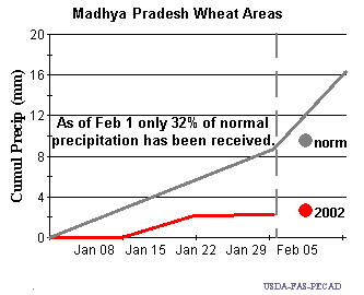
favorable, although the Madhya Pradesh area needs rain. The India wheat
crop will be harvested in late April. The central wheat producing
areas of Madhya Pradesh, and parts of Uttar Pradesh, and all of the minor
southern producing areas had sufficient rainfall for crop establishment, and the
breadbasket region of Punjab and Haryana had adequate irrigation supplies.
The crop is now at jointing to heading stage. Flowering stage will occur in late February for most areas. As of early February, most areas have received normal to below-normal precipitation. At present, the only area of concern is the Madhya Pradesh. Wheat area here is concentrated in the western portion of the state, and is generally grown under rain-fed conditions. Madhya Pradesh typically accounts for 11 percent of India's total production. Timely rainfall will be needed soon, and is particularly important for the critical flowering stage during the next two weeks.
| Cumulative Precipitation: January - February vs. Historical Normal | |
 |
 |
The mostly irrigated states of Punjab and Haryana produce 33 percent of India's wheat. Winter precipitation has been below average in these areas. However, these states and nearby growing areas have adequate irrigation supplies to support crop growth through the season if dry conditions persist.
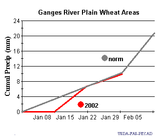
The Uttar Pradesh wheat area is located on the wide Ganges River Plain. Over the past 5 years, thirty-five percent of India's total wheat has come from this region. Recent cumulative precipitation amounts have been near normal and generally satisfactory up to the present date.
| Cumulative Precipitation: January - February vs. Historical Normal | |
 |
 |
