Nez Perce National Historic Trail
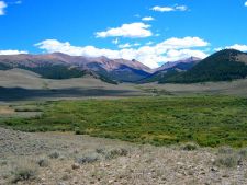
Description: This section of the trail comprises approximately 200 miles of the total 1,170-mile route of the 1877 Nez Perce (Nee-Me-Poo) National Historic Trail. Whether you drive, ride or walk this area, you will gain a unique understanding of the journey of the Nez Perc,e and the tremendous difficulty and odds they had to overcome. The landscape is characterized by high elevations and a dry valley of sagebrush steppe that rises up to over 7,000 feet at Gilmore Summit.
The auto tour brochure “Flight of the Nez Perce” is available at the Public Lands Center in Salmon, Idaho and online.
Directions: Central and Southeastern Idaho
Trailhead Location:
Leadore, Idaho; West Yellowstone Montana; and multiple points between.
The auto route begins in Leadore, Idaho, then descends into the Birch Creek Valley along Highway 28, traverses across the Medicine Lodge area along Highway 22 and Highway 15 to Spencer, parallels the Continental Divide via Clark County Road A2, finally crosses Targhee Pass and enters Yellowstone National Park via West Yellowstone, Montana.
Accessibility:
Leadore, Birch Creek, Targhee Pass
Details:
- Use season: Spring, Summer, Fall
- Route Markers
- Historical Sites and Interpretation
- Nez Perce Historical Brochure
- Eastern Idaho Visitor Center
- West Yellowstone Visitor Center


 Programs