The Interaction Between the Saharan Air Layer and a Tropical Wave
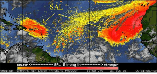
The Saharan Air Layer (SAL), as its name suggests, is a very
dry deep layer of air (typically found between 5,000 and
20,000 feet above the ground) originating from the Sahara Desert
of Africa. Deep easterly winds in the low and middle levels of the
atmosphere transport this SAL across the tropical and portions of
the subtropical Atlantic during the summer, through the Caribbean,
and even into the Gulf of Mexico and surrounding land areas, as
well as the southeastern U.S. Episodes of the SAL passing across
the local area of Puerto Rico and the U.S. Virgin Islands frequently
occur between tropical waves during the summer months. Minerals
and dust from the Sahara suspended within the SAL gradually precipitate
out of the atmosphere as the SAL moves across the Atlantic. It is
this suspended dust that produces the hazy skies during SAL events.
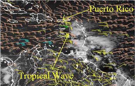
Recent research into the effects of SAL on hurricanes, tropical
cyclones, and tropical waves, shows that this dry layer of air can
wrap into the circulation of developing tropical cyclones and act
to slow down or retard intensification. Also, showers and thunderstorms
developing within and along the edge of the SAL have been shown
to produce squall lines and arcing outflow boundaries as the dry
SAL enhances evaporatively driven downdrafts. A classic case of
this occurred across the local area on the afternoon of June 20th,
2008, as a tropical wave moved through the local area with strong
low level winds, and a broad zone of SAL stretched across and to
the north of the tropical wave.
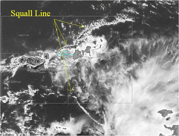
A line of thunderstorms developed across the Anegada Passage and
the Caribbean waters south and southeast of St. Croix. As these
thunderstorms grew and marched northwestward across the Virgin Islands
and adjacent waters, they developed into a squall line with widespread
wind gusts of 30 to 40 knots reported throughout the area, and then
continue to expand west and northwestward as they moved deeper into
the SAL.
|

 National Weather Service Forecast Office