On their way west, Lewis and Clark carried a copy of
A map exhibiting all the new discoveries in the interior parts of
North America ... . When Jefferson met with French ambassador
Louis Andre Pichon in 1803, he traced what became the Lewis and
Clark trail on this map.
Perhaps the most important document for exploration of the West
was Jefferson's
Instructions for Meriwether Lewis. In this letter, the third
president drafted a plan for western exploration "for the purposes
of commerce." The letter became the charter for federal exploration
for the remainder if the 19th century.
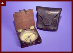
In addition to maps and manuscripts, the exhibition will display
objects such as William
Clark's compass and case, an Indian peace pipe, or calumet,
and a blunderbuss,
or gun like one that would have accompanied the explorers.
The Geography and Map Division of the Library has the world's largest
collection of cartographic materials - more than 4.5 million items.
Many of its maps are online in Map
Collections: 1500-2003. One advantage of viewing these maps
online is that you can zoom in and see them with greater clarity
than with the naked eye. A technology called MrSID
makes it possible. A recent and very noteworthy acquisition by this
division is the map by Martin Waldseemuller of North America. The
map is the opening display in this new exhibition. (See the "Map"
story in this issue for further details on why this map is so important
to the history of America.)
Other presentations on this Web site that relate to Western exploration
include "History
of the American West 1860-1920," "The
First American West: The Ohio River Valley, 1750-1820," "Trails
to Utah and the Pacific: Diaries and Letters, 1846-1869," "American
Indians of the Pacific Northwest" and Reclaiming
the Everglades: South Florida's Natural History, 1884-1934."
These are all from the American Memory collections of 8 million
items from the Library and other repositories. If you type in "exploration"
in the American
Memory Collection Finder Search Page, you will gain access to
thousands of images, maps, manuscripts and other materials relating
to this fascinating topic.
If you are in Washington between now and Nov. 29, don't miss the
opportunity to see "Rivers, Edens, Empires." It is on view in the
Thomas Jefferson Building, at the corner of First Street and Independence
Ave. S.E. (across First Street from the U.S. Capitol), Monday through
Saturday, 10 a.m. - 5 p.m. If not, then enjoy the virtual exhibition
at the Exhibitions home
page, where more than 40 other exhibitions await your exploration.


![Map of Western North America, [1785]](images/lewisclark-b.jpg)