Colorado River - Westwater Canyon
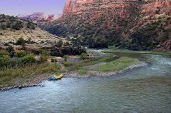
Westwater Canyon is located in a Wilderness Study Area (WSA) northeast of Moab and is the first canyon of the Colorado River within Utah.
Permit required: Yes for private and commercial use. Click here for a list of approved commercial outfitters.
Time: 1 or 2 days
Length of trip: 17 miles from the Westwater Ranger Station to the Cisco Landing take out.
Click here for more information on Westwater Canyon.
Colorado River - Dewey Bridge to Castle Creek

This stretch of the Colorado features easy boater access, close proximity to the city of Moab, moderate rapids, and wonderful scenery. Highway 128 follows the river here.
Private permit required: No for private use, but Yes for commercial use. Click here for a list of approved outfitters.
Time: 1 or 2 days
Length: 16.5 miles from Dewey Bridge to Castle Creek
Dewey Bridge Campground is located along Highway 128, 28 miles from its junction with Highway 191. The campground features a developed but steep boat ramp (please use caution with vehicles here) and adequate boater parking. No fee is charged for use of this ramp. The 7.5 mile Dewey Bridge to Hittle Bottom stretch offers flat water and great views. Roughly half of the trip is within sight of the Fisher Towers and La Sal Mountains.
The "Moab Daily" (a.k.a. Fisher Towers section), a 13-mile section of the Colorado River, runs from Hittle Bottom to Takeout Beach. Depending on time of season and water level, you will encounter rapids on this section ranging from Class I to Class III. Click here for current streamflow conditions. The "Daily" is considered Utah's most popular river trip and is ideal for a short adventure, a group outing, a first river trip, or an overnight camping trip. Utah State Sovereign Lands administers use of the Colorado River downstream of Castle Creek, which is nine miles past Hittle Bottom. However, the BLM maintains river access facilities along the entire "Daily" stretch, including Hittle Bottom, Rocky Rapid (a.k.a. Ida Gulch), Sandy Beach, and Takeout Beach.
Special regulations apply for river runners wishing to camp along this section of the river. On river left (to the left as you are facing downstream), camping is allowed only at improved recreation sites with facilities for overnight use (BLM Utah, Moab Field Office Campgrounds). River runners may camp at undeveloped sites on river right (to the right as you are facing downstream) only between Dewey Bridge and Salt Wash (the boundary of Arches National Park). When camping along river right, you must:
- Use a washable, reusable toilet system that allows for carry-out and proper disposal of solid human waste
- Pack out all trash and dispose of it properly
- Use a durable metal fire pan to contain your campfire. Check on local fire restrictions prior to your trip
Questions? Please call (435) 259-2100
Dolores River - Gateway, CO to Colorado River Confluence
The Lower Dolores stretch offers technical rapids, stunning scenery, wildlife viewing, side-canyon hiking, and great camping.
NOTE: This river segment has a very unpredictable and short boating season.
Private permit required: Yes for private (see below) and commercial use. Click here for a list of approved outfitters.
Time: 2 or 3 days
Length: 32 miles from the Gateway, Colorado bridge to Dewey Bridge Campground (on the Colorado River).
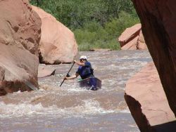
Rapids on this section of the Dolores River range from class I to solid class IV. The most challenging rapid is Stateline (class IV), which begins at the Colorado-Utah border. This mile-long rock garden requires excellent scouting (from river right) and quick maneuvering at all water levels. A mistake made in this this rapid can result in a very long and dangerous swim. Bring an adequate amount of drinking water as the Dolores and its tributaries are unfit for consumption. Land ownership on the Lower Dolores is mixed; please respect the rights of private landowners.
The main roadblock for running this stretch is a very erratic and short (sometimes non-existent) boating season. Flows generally peak between late April and early May. Suggested minimum flows (approximated) are: 200 cfs for canoes, kayaks, and duckies, 800 cfs for rafts less than 14 feet, and 1000 cfs for rafts larger than 14 feet. Click here for current streamflow conditions. For information on current levels at McPhee Reservoir, please visit the Dolores Water Conservancy District (DWCD) website.
Private permits: There is no fee charged and you do not need to submit an application. Simply call (435) 259-7012 between 8 a.m. and noon Monday through Friday (excluding Federal holidays) to obtain a permit. A last-minute reservation request or change to an existing permit can be easily accommodated if you have access to a fax machine. Please note that the permit must be signed by the trip leader and carried on the river to be authorized. By signing, the trip leader agrees to follow the River Use Stipulations that accompany the permit. Please leave your permit in the camp fee tube at the Dewey Bridge campground at the end of your trip. Click here for the river use stipulations for the Lower Dolores River.
Click here for more information on the Dolores River. Questions? Please call (435) 259-2100
Other Rivers in the Area
BLM Grand Junction Field Office
Ruby/Horsethief Canyons (the Colorado River directly above Westwater Canyon)
BLM Monticello Field Office
San Juan River
BLM Price Field Office
Desolation-Gray and Labyrinth Canyons of the Green River
BLM Dolores Field Office
Bradfield Bridge to Bedrock section of the Dolores River
BLM Uncompahgre Field Office
Bedrock to Gateway section of the Dolores River
Private River Trips
Private river trips are organized by individuals on a non-commercial, cost-share basis. On private trips, boaters use their own equipment or rent boats and gear and share trip expenses. Government regulations prohibit individuals utilizing private permits from charging for guide services, trip arrangements, or amortization of equipment.
Questions? Please call (435) 259-2100
River Shuttle Services
Several companies offer shuttle services to boaters visiting Moab area rivers. The Moab Field Office does not endorse nor require permits for individuals or companies providing vehicle shuttle services. Please click here for a current list of shuttle companies.
River Trips with Commercial Outfitters
Outfitters take passengers down all of the river sections listed above. River outfitters offer part-day, one-day, and multi-day trips. Most outfitters conduct trips in more than one river area and provide a wide variety of tours. Some outfitters conduct specialty tours such as self-paddle trips, jet boat tours, executive training sessions, women's trips, and kayak instruction. Many outfitters also provide shuttle and pick-up service. River outfitters on these sections operate under permits issued by the Moab Field Office of the Bureau of Land Management. River guides carrying passengers for hire are licensed by Utah State Parks. All guides are required to have first-aid and CPR training. Please click on a river segment below for a list of outfitters.
Reservations and Fees: Reservations for river trips with an outfitter should be made as far ahead as possible, especially for multi-day trips. Trip prices vary according to trip length, services provided, group size, and river segment.
Equipment Provided: Outfitters generally provide boats, boating equipment, safety equipment such as life jackets and first-aid kits, waterproof bags for storing equipment, watertight boxes for cameras, food, non-alcoholic beverages, ice chests, and return transportation from their office or a pre-arranged meeting place to the river.
Recommended Gear and Clothing: Passengers embarking upon a one-day summertime river trip with an outfitter should bring a sun hat, sun screen, lip gloss, sunglasses with a retention strap, a pair of old sport shoes (they will get wet), a T-shirt, quick drying shorts, a lightweight long sleeve cotton shirt, and a wind breaker. For multi-day trips, passengers will need in addition to the above items, extra clothing for use around camp (evenings can be cool along the river), rain gear, personal care items, and walking shoes for hikes. Passengers may bring their own sleeping bag, ground cloth, and tent or rent these items from the outfitter. Consult with the outfitter for more specific information about clothing, camping gear, and personal use items because requirements vary by trip and season.
State of Utah Boating Regulations
The Utah Division of Parks and Recreation has the primary responsibility for boating safety and enforcement on Utah waters under the Utah Boating Act.
On Utah rivers, every person on board a vessel must wear a personal flotation device (life jacket) of proper size and of an approved type; except on designated flat water areas where they may be loosened or removed. Life jackets must be worn by all persons from 1) Westwater Ranger Station to Big Hole and 2) Onion Creek to Drinks Canyon. Persons under 12 years of age must wear personal flotation devices at all times while on Utah rivers. Utah law also requires that an extra oar or paddle be on board, as well as a bailing device. All motor powered craft must be registered in Utah or in the boater's home state.
Click here for highlights from Utah boating laws and rules.
River Use Ethics
Please exercise the utmost level of care and caution when visiting desert rivers. The following principles should be adhered to during your visit:
- Urinate directly in the river
- Carry and use a portable toilet for solid human waste
- Dispose of human waste in approved facilities
- Respect wildlife encountered along the river
- Camp in previously hardened sites or on beaches
- Pack out all trash (including fire ash, charcoal, and food waste)
- Gather only driftwood for campfires
On commercially outfitted trips, river guides will provide instruction about disposal of human waste, the disposal of different types of trash, and other practices. For private river trips, it is the responsibility of each boater to follow the highest standard of river ethics possible.
Additional Information
River guides are available through the mail or by phone order from the Canyonlands Natural History Association at: 3031 South Hwy. 191, Moab, UT 84532 (435) 259-6003, or visit their website: Canyonlands Natural History Association Bookstore
Further information on outfitter services, accommodations, and shuttles can be obtained by contacting:
Moab Area Travel Council
P.O. Box 550
Moab, UT 84532
(435) 259-8825
(800) 635-6622


 Programs