|
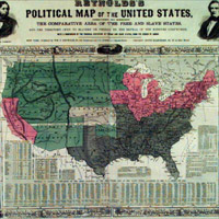
In this 1856 map, the pink represents free states, the dark green represents slave states, and the rest were to be decided, until the Thirteenth Amendment made slavery in the U.S. illegal in 1865

|
|
|
|
Reverdy Johnson Was Born
May 21, 1796
Maryland's position kept the District of Columbia, the capital of the Union, from being surrounded by Confederate states. However, because of strong Southern sentiments within the state, Marylanders lived under martial law during the war; that is, the Union military ruled the state. Several major Civil War battles took place within Maryland's borders, including the Battle of Antietam, the single bloodiest day in American history. After the war, Reverdy Johnson argued for a less harsh treatment of the South by the North, again representing the split attitudes of his state. Do you know which states were slave states and which were not? Take a look at this map.
 page 3 of 3

|