
What is La Niña?
La Niña is defined as cooler than normal sea-surface temperatures (SSTs)
in the tropical Pacific ocean that impact global weather patterns. This deviation from normal
SSTs can have large scale impacts, not only on ocean processes, but also
on the atmosphere. The graphic shown at the lower-left shows a normal SST pattern from December 1993, indicating
no large scale deviations in the SST pattern.
The upper graphic shows the SST pattern from December 1998 which happened to be during
our last La Niña event. It is easy to see the large
broad area of blue, centered on the equator over the eastern Pacific Ocean. This area of blue denotes SSTs which are 2-5
degrees cooler than normal values at that time of year. This is the signal that scientists look for
when diagnosing La Niña events. As can be seen, the size of this cool pool of ocean water is quite large, occasionally
as long as the entire United States!

So how does this large pool of cool water impact the atmosphere?
In normal, non-La Niña conditions (shown in the diagram to the left),
the trade winds blow toward the west across the tropical Pacific Ocean. These winds pile up warm surface water in the
west Pacific, so that the sea surface is about 1/2 meter higher at Indonesia than at Ecuador.
The sea surface temperature is about 8 degrees C higher in the west, with cool temperatures off South America, due to
an upwelling of cold water from deeper layers. This cold water is nutrient-rich, supporting a diverse marine ecosystem and
major fisheries. Rainfall is found in rising air over the warmest water in the western Pacific, and the east Pacific is
relatively dry. In a normal year, the atmosphere typically responds with rising air over the western Pacific and sinking
air over the eastern Pacific, as can be seen in this diagram.
During La Niña, the trade winds strengthen in the central and eastern Pacific
leading to increased upwelling along the South American coast. This cooler pool of water then spreads westward, due to
the increased trade winds until it spreads across much of the eastern Pacific Ocean near the equator.
The normally cool water located off the South American coast becomes increasingly cooler as the upwelling strengthens,
and more sub-surface ocean water is brought to the surface. This leads to
the cool SSTs that were shown at the figure at the top of this webpage, with the strongest deviations from normal just off the
South American coastline and along the equator. The atmospheric response to this pattern, with much higher SSTs in the west,
and much cooler ones over the eastern Pacific, is a strengthening of the normal pattern previously discussed.
Rainfall and rising motion are enhanced over the warm water over the western Pacific, with associated flooding in
Indonesia and Australia. The sinking motion over the eastern Pacific is strengthened further, leading to
a supression of rainfall and dry conditions over portions of South America. This large change in the circulation
pattern forces changes in weather across regions far removed from the tropical Pacific, such as Arizona.
How did it get the name La Niña?
La Niña means The
Little Girl in Spanish. This name was chosen as the opposite of El Niño, the much more famous event. Both
La Niña and El Niño are extreme phases of a naturally occurring climate cycle referred to as El Niño/
Southern Oscillation. For more on El Niño, please see the Science Corner webpage What is
El Niño?.
What are the global impacts of La Niña?
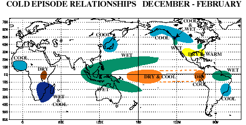
As mentioned, La Niña has impacts that are felt not only near the equator, but far removed from the equator as
can be seen in the figure to the left. A large area of wetter than normal conditions are found in some of the normally wet
regions of the world such as Indonesia and Australia. Places that are normally dry, like western South America and the southwest
United States tend to be even more dry. For the United States, this band of drier than normal conditions extends
across the entire southern portion of the country. Western Canada and Alaska tend to experience a cooler than normal winter
as well. The northwest United States tends to experience wet and cool conditions throughout much of a La Niña
winter. This figure is almost the exact opposite of the one shown for El Niño, showing
how these 'sibling' events are related.
What about the impact of La Niña on northern Arizona?
Global climate La Niña impacts tend to be opposite those of El Niño impacts.
The general effects of La Niña on northern Arizona tend to be felt most during the winter months. This
is due to the stronger jet stream that typically occurs during the winter, when the effects of the cooler pool
of water on the atmosphere are strongest, with a diminished southern jet stream across the state.
Across northern Arizona, La Niña winters tend to have more
prolonged dry periods with fewer and shorter stormy breaks than normal. The storm track tends to have more
storm systems originating from colder regions, and less originating from warmer regions with more moisture
associated with them. Because of this, La Niña winters tend to be cooler and drier than a normal winter across
northern Arizona. For more information, please check out the Science Corner webpage called
How can El Niño and La Niña affect Arizona?
How often do La Niña events occur?
La Niña events tend to occur on average about every 4 to 7 years and typically last for a year. However, La
Niña events can last for two or even three years on occasion. For a list of La Niña (cold) events, please go to the
Climate Prediction
Center List of Cold and Warm Episodes by Season.
How can I find out more about La Niña ?
Numerous webpages can be found on the internet with information regarding La Niña. Those links provided below
are only a few of the locations on the web where you can find more information regarding this ocean-atmospheric
phenomenon.
|


