|
NPS Ocean Park Stewardship Action Plan Brochure PDF National Parks that Conserve Coastal and Oceanic Treasures NPS Underwater, Oceanic or Coastal Related Projects, Programs, Publications and Web Sites Coastal Watershed Condition Assessments Fact Sheet PDF Ocean Stewardship
|
National Park Sites that Conserve Alaska | American Samoa | California | District of Columbia | Florida | Georgia
Alaska Bering Land Bridge National Preserve, AK: The Bering Land Bridge National Preserve is one of the most remote national park areas, located on the Seward Peninsula in northwest Alaska. The Preserve is a remnant of the land bridge that connected Asia with North America more than 13,000 years ago. The majority of this land bridge, once thousands of miles wide, now lies beneath the waters of the Chukchi and Bering Seas. During the glacial epoch this was part of a migration route for people, animals, and plants whenever ocean levels fell enough to expose the land bridge. Archeologists agree that it was across this Bering Land Bridge, also called Beringia, that humans first passed from Asia to populate the Americas. The Preserve's western boundary lies 42 miles from the Bering Strait and the fishing boundary between the United States and Russia. Cape Kruesenstern National Monument, AK: Cape Krusenstern National Monument is a coastal plain dotted with sizable lagoons and backed by gently rolling limestone hills. Cape Krusenstern's bluffs and its series of 114 beach ridges record the changing shorelines of the Chukchi Sea over thousands of years. Glacier Bay National Park and Preserve, AK: The marine wilderness of Glacier Bay National Park and Preserve provides opportunities for adventure, a living laboratory for observing the ebb and flow of glaciers, and a chance to study life as it returns in the wake of retreating ice. Amidst majestic scenery, Glacier Bay offers us now, and for all time, a connection to a powerful and wild landscape. Katmai National Park and Preserve, AK: Katmai is famous for volcanoes, brown bears, fish, and rugged wilderness and is also the site of the Brooks River National Historic Landmark with North America's highest concentration of prehistoric human dwellings (about 900) Kenai Fjords National Park, AK: Sweeping from rocky coastline to glacier-crowned peaks, Kenai Fjords National Park encompasses 607,805 acres of unspoiled wilderness on the southeast coast of Alaska’s Kenai Peninsula. The park is capped by the Harding Icefield, a relic from past ice-ages and the largest icefield entirely within U.S. borders. Visitors witness a landscape continuously shaped by glaciers, earthquakes, and storms. Orcas, otters, puffins, bear, moose and mountain goats are just a few of the numerous animals that make their home in this ever-changing place where mountains, ice and ocean meet.
Lake Clark National Park and Preserve, AK: Lake Clark National Park and Preserve is a composite of ecosystems representative of many regions of Alaska. The spectacular scenery stretches from the shores of Cook Inlet, across the Chigmit Mountains, to the tundra covered hills of the western interior. The Chigmits, where the Alaska and Aleutian Ranges meet, are an awesome, jagged array of mountains and glaciers which include two active volcanoes, Mt. Redoubt and Mt.Iliamna. Lake Clark, 40 miles long, and many other lakes and rivers within the park are critical salmon habitat to the Bristol Bay salmon fishery, one of the largest sockeye salmon fishing grounds in the world. Numerous lake and river systems in the park and preserve offer excellent fishing and wildlife viewing. Sitka National Historical Park, AK: Sitka is located on Baranof Island on Alaska's southeastern panhandle. In addition to the historical sites of the park, Sitka National Historical Park offers visitors a chance to experience the natural world. You can walk in a temperate rain forest under towering trees, observe migrating salmon, explore the intertidal zone, and study wildlife. Park rangers present a variety of naturalist programs to assist visitors in their understanding of the park's natural environment. ors in their understanding of the park's natural environment. American Samoa California
Golden Gate National Recreation Area, CA: Golden Gate National Recreation Area is also rich in natural resources—it is comprised of 19 separate ecosystems in 7 distinct watersheds and is home to 1,273 plant and animal species. With 80 sensitive, rare, threatened, or endangered species —including the Northern Spotted Owl, California Red-legged Frog, and Coho Salmon— the park has the fourth largest number (33) of federally protected or endangered species of all units. Point Reyes National Seashore, CA: Point Reyes National Seashore contains unique elements of biological and historical interest in a spectacularly scenic panorama of thunderous ocean breakers, open grasslands, bushy hillsides and forested ridges. Native land mammals number about 37 species and marine mammals augment this total by another dozen species. The biological diversity stems from a favorable location in the middle of California and the natural occurrence of many distinct habitats. Nearly 20% of the State's flowering plant species are represented on the peninsula and over 45% of the bird species in North America have been sighted. The Point Reyes National Seashore was established by President John F. Kennedy on September 13, 1962. Redwood National Park, CA: Redwood National and State Parks are home to some of the world's tallest trees: old-growth coast redwoods. They can live to be 2000 years old and grow to over 300 feet tall. Spruce, hemlock, Douglas-fir, berry bushes, and sword ferns create a multiple canopied understory that towers over all visitors. The parks' mosaic of habitats include prairie/oak woodlands, mighty rivers and streams, and 37 miles of pristine Pacific coastline. Santa Monica Mountains National Recreation Area, CA: The Santa Monica Mountains are one of the last remaining examples of a relatively undisturbed Mediterranean-type ecosystem in the world. A unique climate, diverse topography, and other factors create a complex assemblage of vegetation types including oak woodland, several types of chaparral, coastal sage scrub, valley oak savanna, grassland, riparian woodland, wetland, and coastal marsh. This vegetation diversity provides abundant habitat for animal species, including 50 species of mammals, close to 400 bird species, and over 35 reptile and amphibian species. These natural resources occur within and adjacent to Los Angeles, the second largest urban area in the nation. District of Columbia
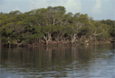
Florida Canaveral National Seashore, FL: Canaveral National Seashore is on a barrier island which includes ocean, beach, dune, hammock, lagoon, salt marsh, and pine flatland habitats. The barrier island and adjacent waterways offer a blend of plant and animal life. Records show that 1,045 species of plants and 310 species of birds can be found in the park. Visitors may enjoy walking the nature and historical trails during the cool winter months. Throughout the year opportunity for recreational activities include; lagoon and surf fishing, boating, canoeing, surfing, sunbathing, swimming, hiking, horseback riding and backcountry camping. DeSoto National Memorial, FL: De Soto National Memorial is embraced by the waters of Tampa Bay and the mouth of the Manatee River, and includes over thirty acres of intertidal mangrove forest and coastal hammock uplands. Daily, this unique environment is flooded by tidal waters from Tampa Bay and the Manatee River. These nutrient rich tidal waters nourish specialized plant and animal communities which are dependent upon the ebb and flow of the tide. The park's raised boardwalk offers visitors an opportunity to experience the mangrove ecosystem first hand. As you travel over this tangle of branches and prop roots, you can easily imagine the same area during the spring of 1539. Place yourself in the boots of the conquistadors, trudging through this seemingly impenetrable natural barrier. Dry Tortugas National Park, FL: 70 miles west of Key West, Florida are the rare and beautiful coral reefs, seagrass beds, and remote keys known as Dry Tortugas National Park, with historic Fort Jefferson, the Civil War era military outpost at its center. Here creatures like the queen conch, the aptly–named brain coral, and endangered sea turtle coexist, interconnected in their plight to survive. Coral formations shelter dozens of colorful fish. A walk along the fort’s moat wall provides ample opportunity to see an assortment of marine creatures thriving in sea grass meadows. Sea grasses are vital to the neighboring corals as they block polluting sediments from reaching these living animals. While its beauty is stunning, some of the park’s most treasured wonders are at risk. Elkhorn and staghorn corals are listed as threatened under the Endangered Species Act. Fragile coral formations, displaying hundreds of years of growth, can be destroyed in seconds by a carelessly placed boat anchor or snorkel fin. Water pollution and sediments, from land or boats, muddy the clear waters that sustain the reef. Non–native plants and animals interfere with natural processes. The new Research Natural Area provides protection from fishing and anchoring and hope for restoration of corals, fish and seagrass.
Everglades National Park, FL: Spanning the southern tip of the Florida peninsula and most of Florida Bay, Everglades National Park is the only subtropical preserve in North America. It contains both temperate and tropical plant communities, including sawgrass prairies, mangrove and cypress swamps, pinelands, and hardwood hammocks, as well as marine and estuarine environments. The park is known for its rich bird life, particularly large wading birds, such as the roseate spoonbill, wood stork, great blue heron and a variety of egrets. It is also the only place in the world where alligators and crocodiles exist side by side. Gulf Islands National Seashore, FL/MS: Gulf Islands National Seashore is known for its snowy white-quartz beaches, and emerald blue-green waters that stretch 160 miles from Cat Island in Mississippi to the eastern tip of Santa Rosa Island in Florida. Natural beauty, recreational opportunities and historic richness abound at Gulf Islands National Seashore. Offshore islands with sparkling white sand beaches, historic forts and related historic structures, nature trails and adjacent open waters describe the nation's largest national seashore. Timucuan Ecological and Historic Preserve, FL: The 46,000 acre Timucuan Ecological and Historic Preserve was established to protect one of the last unspoiled coastal wetlands on the Atlantic Coast, and to preserve historic and prehistoric sites within the area. The estuarine ecosystem includes salt marsh, coastal dunes, and hardwood hammocks, all rich in native vegetation and animal life. Georgia
Fort Pulaski National Monument, GA : The 5400 acre Monument consists of tidal marshes and mud flats that are subject to daily inundation of a six to ten foot tide. These two islands that make up the site were, before human intervention, primarily salt marsh. Judging from the composition of existing vegetation, Cockspur Island probably supported some coastal hammock forest or woodland. McQueens Island makes up the largest portion of land holdings for the Monument (about 4,900 acres) and the majority of this consists of salt marsh. Guam Hawaii Hawai'i Volcanoes National Park, HI : Hawai'i Volcanoes National Park, established in 1916, displays the results of 70 million years of volcanism, migration, and evolution -- processes that thrust a bare land from the sea and clothed it with complex and unique ecosystems and a distinct human culture. The park encompasses diverse environments that range from sea level to the summit of the earth's most massive volcano, Mauna Loa at 13,677 feet. Kilauea, the world's most active volcano, offers scientists insights on the birth of the Hawaiian Islands and visitors views of dramatic volcanic landscapes. Kalaupapa National Historical Park, HI : The park contains the Kalaupapa Peninsula, adjacent cliffs and valleys, and submerged lands and waters out to 1/4 mile from shore. Hawaiian people inhabited the peninsula and valleys for hundreds of years prior to the establishment of the isolation settlement at Kalawao in 1866. Evidence of this occupation in four ahupua`a (historic Hawaiian land divisions) on the peninsula and in valleys is relatively undisturbed and represents one of the richest archeological preserves in Hawai`i. Spectacular north shore sea cliffs, narrow valleys, a volcanic crater, rain forest, lava tubes and caves, and off-shore islands and waters are in the national park, including 2,000 acres of ocean waters including corals and a diverse variety of marine plants and animals. Several of these areas provide rare native habitat for threatened or endangered Hawaiian plants and animals. For example, Hawaiian Monk seal pups have been born on Kalaupapa's beaches. These endangered mammals require solitude; Kalaupapa's physical isolation provides perfect habitat to support these births and subsequent care. Kaloko-Honokohau National Historical Park, HI: Established in 1978 for the preservation, protection and interpretation of traditional native Hawaiian activities and culture, Kaloko-Honokohau NHP is an 1160 acre park full of incredible cultural and historical significance. The park’s ocean resources encompass 700 acres of nearshore waters with a coral reef community of fish, invertebrates and plant. It is the site of an ancient Hawaiian settlement which encompasses portions of four different ahupua'a, or traditional sea to mountain land divisions. Resources include fishponds, kahua (house site platforms), ki'i pohaku (petroglyphs), holua (stone slide), and heiau (religious site). Pu'uhonua o Honaunau National Historical Park, HI: The peaceful waters of Honaunau Bay lap upon shores of Keone'ele Cove. The majestic waters of the blue pacific stretch out before you beyond the stark lava landscape. Perhaps you will spot a green sea turtle swimming nearby or encounter a native Hawaiian plant along the trail. The power and beauty of the natural landscape surrounds you at Pu'uhonua o Honaunau. Pu'ukohola Heiau National Historic Site, HI: With less than 10 inches of annual rainfall, this is one of the driest locations in the Hawaiian archipelago. Ruins of Pu'ukohola Heiau (“Temple on the Hill of the Whale”), built by the great King Kamehameha lie adjacent to marine waters where sea turtles, fish and other creatures move together with the ocean’s rhythms. USS Arizona Memorial, HI: Oil droplets bubble to the surface of Pearl Harbor above the sunken battleship, USS Arizona, creating a vivid link to the past. On a quiet Sunday morning, December 7, 1941, Japanese naval air forces launched a surprise attack on the island of Oahu leaving the Pacific Fleet and the surrounding airfields in smoldering ruins. Here, peace was interrupted and World War II began in the Pacific. In a few hours, 2,390 futures were taken. Nearly half of these casualties were from the USS Arizona. Behind the shadows of destroyed airfields, aircraft and ships, America fought fear and a determined enemy by responding with an unrivaled war effort. In the wake of the "day of infamy", an epic battle for democratic ideals and world freedom would bloody the fields of Europe and the islands of the Pacific over the next four years. The USS Arizona Memorial became a national shrine in 1962. To many, it symbolizes American sacrifice and resolve. Through this national tragedy, a new America emerged. The United States would reluctantly assume global power and with it, new global responsibilities. Today, the USS Arizona stands as a reminder of the events of that Sunday morning. It has different meanings for the millions who visit here but to all of them, it speaks silently and eloquently of the distance yet to be traveled before the world lives in peace. Indiana
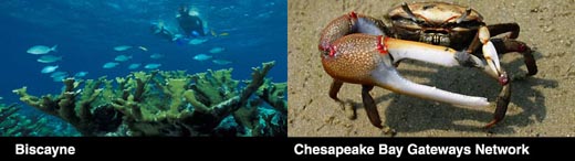
Louisiana Maine Maryland Chesapeake Bay Gateways Network, DC, MD, VA, WV, NY, PA: As the largest estuary in North America, the Chesapeake Bay has touched and influenced much of the American story – early settlement, commerce, the military, transportation, recreation and more. The Bay and its surrounding 64,000 square mile watershed hold a treasure trove of historic areas, natural wonders and recreational opportunities. Experience the diversity of the Chesapeake Bay through the Chesapeake Bay Gateways Network – a system of over 120 parks, refuges, museums, historic communities and water trails in the Bay watershed. Each of these sites tells a piece of the vast Chesapeake story. Massachusetts Cape Cod National Seashore, MA: Cape Cod National Seashore comprises 43,604 acres of shoreline and upland landscape features, including a forty-mile long stretch of pristine sandy beach, dozens of clear, deep, freshwater kettle ponds, and upland scenes that depict evidence of how people have used the land. A variety of historic structures are within the boundary of the Seashore, including lighthouses, a lifesaving station, and numerous Cape Cod style houses. The Seashore offers six swimming beaches, eleven self-guiding nature trails, and a variety of picnic areas and scenic overlooks.
Michigan Pictured Rocks National Lakeshore, MI: Multicolored sandstone cliffs, beaches, sand dunes, waterfalls, inland lakes, wildlife and the forest of the Lake Superior shoreline beckon visitors to explore this 73,000+ acre park. Attractions include a lighthouse and former Coast Guard life-saving stations along with old farmsteads and former logging trails. The park is a four season recreational destination where hiking, camping, hunting, nature study, and winter activities abound. At its widest point the Lakeshore is only five miles and hugs the Superior shoreline for more than 40 miles. This was the first National Lakeshore and was authorized in 1966. Sleeping Bear Dunes National Lakeshore, MI: 35 miles of Lake Michigan coastline, on the mainland of Michigan, as well as around North and South Manitou Islands, are protected at this site. The park was established primarily for its outstanding natural features, including forests, beaches, dune formations, and ancient glacial phenomena. The Manitou Passage State Underwater Preserve is adjacent to the Lakeshore. The Preserve protects more than 80 shipwrecks, many in shallow water. Beachcombers often discover shipwreck timbers that they then report to park officials as historic artifacts. Mississippi New Jersey New York
Fire Island National Seashore, NY: Pristine ocean shores, an ancient maritime forest, legacies of lighthouse keepers, and the historic estate of William Floyd are just a few of the recreational, natural, and cultural resources of Fire Island National Seashore. Fire Island National Seashore was established "for the purpose of conserving and preserving for the use of future generations certain relatively unspoiled and undeveloped beaches, dunes, and other natural features... which possess high values to the Nation as examples of unspoiled areas of great natural beauty in close proximity to large concentrations of urban population." Public Law 88-587 (Sept. 11, 1964). Gateway National Recreation Area, NJ, NY : Gateway NRA is a 26,000 acre recreation area located in the heart of the New York metropolitan area. The park extends through three New York City boroughs and into northern New Jersey. Swimming, sailing, surfing and fishing; --Learning about ecosystems and their relationship to city life; --Touring historic military sites; --Gardening, photography and poetry readings; --Opera, symphony, and contemporary music and cultural festivals; --Organized athletics --soccer, football, baseball, tennis and cricket; --Bird watching, beach clean-ups and nature talks; --Camping, cycling and ...sunset walks. North Carolina Cape Lookout National Seashore, NC: The seashore is a 56 mile long section of the Outer Banks of North Carolina running from Ocracoke Inlet on the northeast to Beaufort Inlet on the southeast. The three undeveloped barrier islands which make up the seashore - North Core Banks, South Core Banks and Shackleford Banks - may seem barren and isolated but they offer many natural and historical features that can make a visit very rewarding. Oregon Pennsylvania Texas
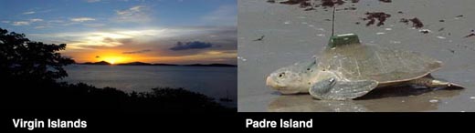
U.S. Virgin Islands Salt River Bay National Historic Park & Ecological Preserve, Virgin Islands: Salt River Bay’s natural history, its vitally important ecosystem of mangroves, estuary, coral reefs, and submarine canyon, has witnessed thousands of years of human endeavor. Every major period of human habitation in the Virgin Islands is represented: several South American Indian cultures, the 1493 encounter with Columbus, Spanish extermination of the Caribs, attempts at colonization by a succession of European nations, and enslaved West Africans and their descendants. More than a dozen major archeological investigations since 1880, together with historical research, reveal this remarkable story. Few places engage the imagination so completely, drawing visitors into the spirit of the place and its beauty and sanctity. You can help ensure that this park and its unique stories will always be here to inspire people about our shared heritage.
Virgin Islands Coral Reef National Monument, Virgin Islands : The clear waters surrounding St. John support a diverse and complex system of coral reefs. The health of these reefs is closely tied to its component plants and animals as well as adjacent non-coral marine environments such as sandy bottoms, seagrass beds, and mangrove forests. The monument includes 12,708 acres of federal submerged lands within the 3-mile belt off of St. John, including Hurricane Hole and areas north and south of St. John. Virgin Islands National Park, Virgin Islands: Virgin Islands National Park, renowned throughout the world for its breathtaking beauty, covers approximately 3/5 of St. John, and nearly all of Hassel Island in the Charlotte Amalie harbor on St. Thomas. Within its borders lie protected bays of crystal blue-green waters teeming with coral reef life, white sandy beaches shaded by seagrape trees, coconut palms, and tropical forests providing habitat for over 800 species of plants. To these amazing natural resources, add relics from the Pre-Colombian Amerindian Civilization, remains of the Danish Colonial Sugar Plantations, and reminders of African Slavery and the Subsistence Culture that followed during the 100 years after Emancipation - all part of the rich cultural history of the Park and its island home. Virginia Washington Olympic National Park, WA: Olympic National Park's 73-mile long wilderness coast is a rare treasure in a country where much of the coastline is prime real estate. The rocky headlands, beaches, tidepools nurturing a living rainbow of colors and textures, off shore sea stacks topped by nesting seabirds and wind-sheared trees—all are a remnant of a wilder America. In 1988, Congress added much of the narrow coastal strip of the park to a national system of designated wilderness. The intertidal areas, where the Pacific Ocean tides shape life, are also within the boundary of the Olympic Coast National Marine Sanctuary. The offshore islands with their colonies of nesting seabirds and rocky haulouts for seals and sea lions, lie within the Washington Maritime National Wildlife Refuge Complex. Peer into a tidepool and your view may take in hundreds of animals crowded into an area the size of a dinner plate. Cold, nutrient-rich waters upwelling from the Pacific Ocean floor feed a food chain extending from tiny invertebrates to many-ton whales. In the intertidal, that abundance is stacked in layers determined by the tides, competition and the reach of predatory neighbors. San Juan Island National Historical Park , WA : San Juan Island National Historical Park preserves and protects a diverse variety of natural features, ecological communities, ecosystem components, and niche habitats in its two units on San Juan Island. San Juan Island is one of the two largest islands in the San Juan Archipelago. North of Puget Sound, the San Juan Islands are nestled between Canada’s Vancouver Island, the Strait of Georgia, the inland coast of northwest Washington state, and the Strait of Juan de Fuca. The San Juan Islands lie in the center of the geographically, culturally and ecologically defined region known as the Salish Sea. The environmentally sensitive coastal areas of the San Juan Islands are regarded as among the more diverse intact marine ecosystems in the nation. Lewis & Clark National Historical Park , OR, WA : Lewis & Clark National Historical Park incorporates state parks in Washington and Oregon along with the current Fort Clatsop National Memorial Park. The sites preserved in these parks allow you to walk where Lewis and Clark and the rest of the Corps of Discovery walked. Ecosystems within the park vary from estuarine mudflats and tidal marshes to shrub wetlands, forested swamps, and coastal temperate rainforest dominated by Sitka spruce as large as six feet in diameter. Wetlands comprise approximately half the park's acreage and include the tidally influenced Lewis and Clark River, low-gradient brackish sloughs, freshwater ponds, and several small freshwater streams and springs. These wetlands provide valuable habitat for a number of threatened and sensitive fish, amphibian, bat and bird species. Bald eagles nest in the area and can often be seen in flight or perching along the river. West Virginia Wisconsin |
Last Update: December 5, 2006