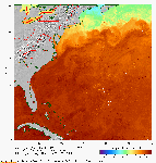
Sea Surface Temperature: APL receives AVHRR satellite data from the NOAA polar orbiting satellites. These data are processed into images of SST in near real-tme. Here is the latest 7-day composite of the Gulf Stream.
|
SAR Winds: APL processes SAR imagery from the Radarsat-1 satellite into
wind speed in near real time. Here is the latest processed
SAR wind speed image and a map of the latest coverage.


|
DC Lightning Mapping Array APL is a participating ground station in the DC Area Lightning Mapping Array.
The LMA is not yet operational. The image below is Nexrad radar reflectivity.

|
|
|
|
|


 Publications 1994-2005