

Images & Animations
-
Credit
<p>Image courtesy Jesse Allen, NASA Earth Observatory; data provided by the USGS EROS Data Center Satellite Systems Branch.</P>
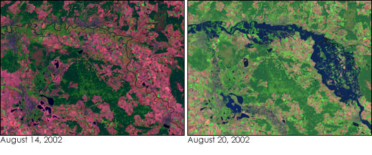
Heavy rains in Central Europe over the past few weeks have led to some of the worst flooding the region has witnessed in more than a century. The floods have killed more than 100 people in Germany, Russia, Austria, Hungary, and the Czech Republic and have led to as much as $20 billion in damage. This false-color image of the Elbe River and its tributaries (right) was taken on August 20, 2002, by the Enhanced Thematic Mapper plus (ETM+), flying aboard the Landsat 7 satellite.
The floodwaters that inundated Dresden, Germany, earlier this week have moved north. As can be seen, the river resembles a fairly large lake in the right-hand side of the image just south of the town of Wittenberg. Flooding was also bad farther downriver in the towns of Magdeburge and Hitzacker. When this image was taken, tens of thousands of people had been evacuated from their homes in Germany. Fifty thousand troops, border police, and technical assistance workers were called in to combat the floods along with 100,000 volunteers. Normally, the river would just resemble a thin line (left, image acquired August 14, 2002).
Though these false-color images may appear slightly different, both images encompass the same land area and both were created using the same ETM+ bands. In the right-hand image, land is primarily green with a little red, water is blue, and cities are slate gray. In the left-hand image, land is primarily red with patches of green, water is nearly black, and cities are purple.
Metadata
-
Sensor
Landsat 7/Landsat 7 -
Visualization Date
2002-08-23