Natural Hazards
Back to Natural Hazards Gateway Home
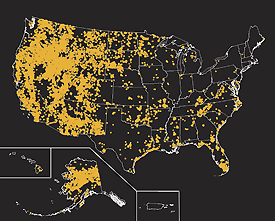 This map shows locations that experienced wildlfires greater than 250 acres, from 1980 to 2003. Map not to scale. Sources: Bureau of Land Management, U.S. Forest Service, U.S. Fish and Wildlife Service, Bureau of Indian Affairs, National Park Service, and the USGS National Atlas (Hi-res | Low-res) Natural Hazards - WildfiresWildfires are a growing natural hazard in most regions of the United States, posing a threat to life and property, particularly where native ecosystems meet developed areas. However, because fire is a natural (and often beneficial) process, fire suppression can lead to more severe fires due to the buildup of vegetation, which creates more fuel. In addition, the secondary effects of wildfires, including erosion, landslides, introduction of invasive species, and changes in water quality, are often more disastrous than the fire itself. The USGS, in conjunction with the U.S. Forest Service and other partners, provides tools and information by identifying wildfire risks and ways to reduce wildfire hazards, providing real-time firefighting support, and assessing the aftermath of wildfires. The goal is to build more resilient communities and ecosystems.
|
|
USGS Wildfire Related News (USGS Newsroom)
|
Highlighted Wildfire Resources Select the
|

![]() U.S. Department of the Interior |
U.S. Geological Survey
U.S. Department of the Interior |
U.S. Geological Survey
URL: http://www.usgs.gov/hazards/wildfires/default.asp
Page Contact Information: Ask USGS
Page Last Modified: Tuesday, July 08, 2008
