 |
|
 |
|
|
|
|
|
|
|
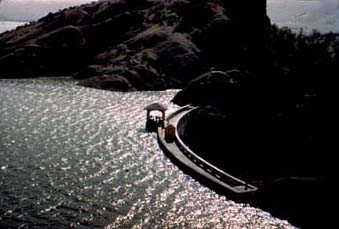
The Orland Project, in north-central California, is located in the Sacramento Valley about 100 miles north of Sacramento. The project incorporates parts of neighboring Glenn, Tehama, and Colusa Counties. The hub of the project, the town of Orland, is in northern Glenn County. One of the smallest projects ever tackled by Reclamation, the project irrigates one percent of the Sacramento Valley's total irrigable soil, 20,000 acres. The project, one of the oldest federal reclamation projects in the country and one of the first undertaken in California, was authorized by the Secretary of the Interior in October 1907 after a finding of feasibility by a board of engineers. Water was delivered to the first farm units at the beginning of the 1910 growing season. The project is irrigated by Stony Creek, a tributary of the Sacramento River. Flowing northward, the creek gathers water drained from the surrounding slopes of the Coast Range Mountains. The collected water irrigates lands on both sides of the creek near the town of Orland. The Orland Project comprises two main dams to store water, East Park and Stony Gorge, two diversion dams, almost 17 miles of canals, and 139 miles of laterals. Orland has some of the best conditions for agriculture. The growing season lingers over 262 days from March to November. The project´s soil is considered some of the richest and most productive in the nation. Orland, and the Sacramento Valley, is warmed by a thermal belt, with very few frosts. Average rainfall is 17.99 inches, most of which is measured between the first of November and the first of April. With hardly any snow, winter runoff occurs almost immediately after precipitation. The project has an average annual runoff of 410,000 acre feet. The project plan provides for storage of water in East Park and Stony Gorge Reservoirs. Rainbow Diversion Dam and Northside Diversion Dam are the main diversion structures of the project. Rainbow Diversion Dam diverts water from Stony Creek through the East Park Feed Canal to East Park Reservoir to furnish a supplemental water supply for that reservoir. Northside Diversion Dam diverts water from Stony Creek into the North Canal for lands lying on the north side of the creek in the vicinity of Orland. Originally Southside Diversion Dam, located at the site of the present Black Butte Dam, diverted water into the South Canal for lands south of the creek. Since Black Butte Dam and Reservoir were completed in 1963, this diversion has been made directly from the reservoir. Black Butte Dam and Reservoir are not a part of the Orland Project. They were constructed by the Corps of Engineers primarily for flood control purposes in 1960-1963. By Public Law 91-502, October 23, 1970 (84 Stat. 1097), Black Butte is financially integrated and operationally coordinated with the Central Valley Project by the Bureau of Reclamation. Physical operation and maintenance of Black Butte Dam and Reservoir are retained by the Corps of Engineers. Unit descriptions and facilities East Park Dam, on Little Stony Creek about 33 miles southwest of the town of Orland, was completed in 1910. The reservoir has a storage capacity of 50,900 acre-feet and stores surplus water for irrigation purposes. Releases and spills from the reservoir flow down Stony Creek 18 miles for re-storage in Stony Gorge Reservoir. The dam is a curved, concrete thick-arch gravity structure with a height of 139 feet and a crest length of 266 feet. The dam contains 12,200 cubic yards of concrete. A circular conduit 20 feet above the riverbed constitutes the main outlet. It is controlled by two 4 X 5 foot sluice gates seven feet apart. The outlet works are made up of a pagoda shaped control house, gate tower, four slide gates and a 24-inch-diameter cast iron sluice pipe. The spillway is about 2,000 feet away from the dam in a natural saddle and holds 1,090 cubic yards of concrete. The structure features nine vertical, semi-circular arches and has an effective length of 414 feet, with a capacity of 10,000 cubic feet. The East Park Dam was placed on the National Registry of Historic Places in the mid-1980s. Stony Gorge Dam, completed in 1928, is on Stony Creek about 18 miles downstream from East Park Dam, 5 miles west of Fruito, and 20 miles west of the town of Willows in western Glenn County. The reservoir, which has a storage capacity of 50,380 acre-feet, regulates flows along the lower reaches of Stony Creek and stores surplus water for irrigation purposes. Releases from the reservoir travel 22 miles down Stony Creek to the project's diversion points. The dam is a concrete slab and buttress structure with 46 bays, a height of 139 feet and a crest length of 868 feet. It is one of the earliest examples of an Ambursen-type dam, which uses contraction joints between all face slabs and buttresses to help protect the dam against earthquakes. The outlet works at the base of the dam are designed to pass a little over 1,000 cubic feet per second through 50-inch diameter pipes. The spillway can discharge up to 30,000 cfs controlled by three 30 by 30 feet gates mounted on the upstream face of the dam. These overflow gates are operated by stems connected by electric hoists located in the spillway gate house on top of the dam. Stony Gorge Reservoir has a storage capacity of 50,200 acre-feet and a surface area of 1,280 acres. It extends upstream from the dam for five-and-a-half miles and stores the run-off from a drainage area of 275 square miles. Releases from the reservoir travel 22 miles down Stony Creek. A rehabilitation and betterment program in the late 1940s replaced rotting timbers on diversion structures, opened corroded spillway gates on Stony Gorge Dam, and restored lining on the North and South Main Canals. Rainbow Diversion Dam and Feeder Canal Rainbow Diversion Dam is on Stony Creek about 3 miles west of the town of Stonyford. Its function is to divert part of the high flows of Stony Creek into the 7-mile-long East Park Feed Canal and then into East Park Reservoir to supplement the natural inflow to that reservoir. The dam, completed in 1914, is a concrete arch structure with a height of 44 feet and a crest length of 271 feet. Northside Diversion Dam is on Stony Creek about 5 miles northwest of Orland. Its function is to divert water into the headworks of the North Canal. The dam is a concrete gravity structure with a height of 15 feet and a crest length of 375 feet. It was completed in 1913 and partially replaced in 1954. The rest of the dam was replaced in 1956. Canal and Distribution system The canal and distribution system was designed to deliver water directly to each 40-acre unit in the project. It contains 16.9 miles of canals, including the East Park Feed Canal, 117.6 miles of laterals, and about 2,000 concrete control structures. Concrete lines 120 miles of the canals and laterals, and 5.6 miles of the laterals are in pipe. Operating agency The Orland Unit Water Users' Association has operated the project since October 1, 1954. History The rapid development of the Central Valley in California began in 1849 after the discovery of gold. Cattle raising was the primary activity for the next decade, but at the same time various forms of agriculture were being established. First planted in the 1860s, wheat soon dominated the socio-economic life of the Sacramento Valley. Wheat was easy to grow and required little continuing investment. During the late 1890s, as the wheat yield decreased across the farming communities of northern California, grain farming shifted its emphasis from feeding humans to feeding livestock, and cattle ranching increasingly dominated the local economy. Along Stony Creek, isolated individual attempts at irrigated farming began before 1880. On Stony Creek and its tributaries above Orland, 40 to 50 separate water diversions were built in the 1880s and 1890s. Investigations The Reclamation Service began investigations in the Sacramento Valley in 1902. Included in these investigations was an area involving 40,000 to 50,000 acres located on Stony Creek on the west side of Sacramento Valley close to the town of Orland. Three reservoir sites for water storage were considered; the East Park site was the most promising for development. The proposed dam was to be 115 feet high, capable of storing 26,000 acre-feet of water. A committee of citizens took the initiative of obtaining signatures on a petition to the Secretary of the Interior. The petition was presented in May 1906 and an engineering board was appointed to present a detailed report. This report favored building a dam at the East Park site which would be 139 feet high and provide a storage capacity of 46,000 acre-feet. As early as 1909, preliminary surveys had been made on the Stony Gorge site. Supplemental surveys made in 1918 confirmed that an additional water supply for the project might be expected at this site. A vote of the water users, following a dry season in 1924 when there was considerable agricultural loss, resulted in unanimous approval of the dam. Authorization The project was authorized by the Secretary of the Interior on October 5, 1907. Construction Construction of East Park Dam was started on August 27, 1908, and completed in 1910. Northside Diversion Dam was built during the same period. Rainbow Diversion Dam and East Park Feed Canal were constructed in 1913-1915 when it was determined that insufficient water was being stored for project use. The original canal system was unlined, but a supplemental agreement with the water users signed in 1918 provided for concrete lining. Under the resulting program, 1.5 inches of un-reinforced concrete lining in varying lengths was placed throughout the summer of 1924. Since then, additional lining has been placed as required where heavy transit and maintenance costs were encountered. Stony Gorge Dam was started in 1926 and finished in October 1928. In April 1954, Northside Diversion Dam failed. Temporary repairs permitted water service during the 1954 irrigation season, and permanent replacement was made during the following fall and winter. Irrigation The principal crops are irrigated pasture, wheat, alfalfa, hay, sorghum, olives, nuts, and citrus fruits. Dairying is an important business due to the mild climate, good market, and feed conditions. The hills and mountains west of the project are used extensively for grazing of sheep and cattle. This project has had dramatic results--the value of the crops in 1921 alone was $45,000 more than the value of the project lands in 1910, before the project. In 1991, the project irrigated 19,160 acres which produced $9.7 million in crops. Recreation East Park and Stony Gorge Reservoir areas provide campgrounds, including trailer space, picnicking areas, swimming, boating, and fishing, primarily for bluegill and largemouth bass. Reclamation manages the recreation facilities. |
||
|
|
||
|
Dams | Projects | Powerplants | Contact Us | Maps | Glossary | FAQ´s | Links |
||