 |
|
 |
|
|
|
|
|
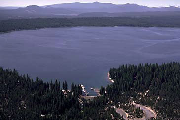
The Crescent Lake Dam Project is composed of lands of the Tumalo Irrigation District on the west side of the Deschutes River near Bend, Oregon. The principal feature of the project is Crescent Lake Dam, located at the outlet of Crescent Lake. The lake is a large natural body of water formed in a glacial deposit high on the eastern slopes of the Cascade Range. Canals, pipelines, and distribution laterals in the project furnish a full irrigation water supply to over 8,000 acres of land. Developed by private interests, various project facilities have been rehabilitated by or through the assistance of the Bureau of Reclamation. Plan Water rights are owned on Tumalo Creek, Little Crater Creek, Crater Creek, Three Springs, and the Deschutes River. Water from the Deschutes River is stored and released when required from Crescent Lake. The water is diverted and delivered to project lands through the privately constructed canal and lateral system. Unit descriptions and facilities Crescent Lake Dam and Crescent Lake The original dam was removed and a new Crescent Lake Dam was constructed in 1986 by the Bureau of Reclamation to provide a total capacity of 91,700 acre-feet (active 86,900 acre-feet) being constructed over a natural lake having unknown dead storage. The 450-foot long new earthfill dam has a height of 40 feet at its crest. The outlet works conduit has a capacity of 1,325 cubic feet per second. An uncontrolled spillway, 45 feet wide, is in a saddle on the right abutment. As part of the operation and maintenance program, the dam crest was repaired and brought up to grade in 1998. Canals and Laterals The district had been experiencing high water losses in its carriage system that included over 13,300 feet of metal Lennon flumes supported by old wood-trestle. Major facilities rehabilitated included replacing three flumes on the Bend Feed Canal, totaling 10,500 feet, with 72-inch pipeline. The 750-foot tunnel section of the canal, originally lined with untreated wood, was replaced with 78-inch asbestos bonded and coated corrugated metal pipe. The headworks and rubble masonry section at the diversion dam was gunite lined with a 2.5-inch-thick reinforced concrete layer. One Lennon flume on the Tumalo Feed Canal was replaced with 2,830 feet of 54-inch pipeline. Other minor rehabilitation work was completed on the canal and lateral systems. In 1996 the Tumalo Irrigation District replaced a 78-inch diameter, above ground redwood wood-stave pipe with a 927 foot length, 62 inch-diameter buried welded steel pipeline (concrete mortar encased), located on the Bend Feeder Canal. In 1997 the Tumalo Irrigation District transferred the Columbia Southern Canal diversion, on Tumalo Creek, to the Tumalo Feed Diversion approximately 8.4 miles downstream and eliminated the upper diversion. This was accomplished by installation of a 3,000 foot, 60-inch buried pipeline, which parallels an existing 48-inch diameter pipeline. This enables the district to divert their full Tumalo Creek water right of 200 cubic-feet-per-second at one single diversion point. Operating agencies The Tumalo Irrigation District operates and maintains the project. Tumalo Irrigation District´s financial obligation to the Bureau of Reclamation was repaid in 1998. History The history of irrigation in the general project area dates back to 1871 when individual farmers diverted water from Squaw Creek, a tributary of the Deschutes River. Following the simple individual diversions, community irrigation enterprises were developed. The Deschutes County Municipal Improvement District had its beginning in 1902 as a State project for the irrigation of lands under provisions of the Carey Act. At first, only direct flow from Tumalo Creek was available, but later Tumalo Reservoir was constructed in a dry basin near the upper edge of the project and was to be filled through a 7-mile feeder canal from Tumalo Creek. The reservoir failed to hold water. In 1922, the project was reorganized into the present district organization and, because of water shortages, the acreage was reduced from the initially contemplated area of 27,000 acres to 15,400 acres. On March 9, 1959, the organization changed its name to the Tumalo Irrigation District. To augment the water supply from Tumalo Creek, the storage right of the Walker Basin Irrigation Company at Crescent Lake was purchased, and a reservoir with a capacity of 86,900 acre-feet constructed. A 9.5-cubic-foot-per-second continuous flow water right in the Deschutes River was obtained from the city of Bend. Also constructed at that time was the diversion dam in the Deschutes River at Bend, the Bend Feed Canal, and other physical works. The irrigated acreage has been reduced considerably from the initial plan. A timber-crib dam was built across Crescent Creek at the outlet of Crescent Lake, and storage was begun in 1922. In the intervening years, there had been a steady deterioration in the timbering and fill, and after 1946, storage was limited to 54,860 acre-feet, 32,000 acre-feet less than the reservoir's capacity. At the end of the 1953 irrigation season, storage was further reduced to 36,000 acre-feet, and the outlet gates were difficult to operate. A program of reconstruction was urgently required to ensure both the safety of the dam and a dependable storage water supply to maintain productiveness on district lands. Investigations Assistance was requested by the local organization, and Crescent Lake Dam was investigated by the Bureau of Reclamation. Investigations of the canal and lateral system were performed by a private organization. Both investigations led to authorization for rehabilitation. Authorization The emergency rehabilitation of Crescent Lake Dam was authorized on July 1, 1954, by the Interior Department Appropriation Act, 1955 (68 Stat. 361, Public Law 83-465). Rehabilitation of the canal and lateral system, to be accomplished pursuant to the Rehabilitation and Betterment Act of October 7, 1949 (63 Stat. 724, Public Law 81-335) as amended, was authorized on October 7, 1970, by the Public Works Appropriation Act, 1971 (84 Stat. 890). The authorized project purpose is irrigation. Construction Reconstruction of Crescent Lake Dam was begun in 1955 and completed in 1956. Rehabilitation of the canal and lateral system began in 1974 and was completed in 1977. Irrigation Grain, alfalfa, grass hay, and irrigated pasture are the principal crops produced. Recreation Crescent Lake lies wholly within the Deschutes National Forest which administers recreation on the reservoir. Located less than 7 miles from the crest of the Cascade Mountain Range, the reservoir area has 1,985 acres of land available for recreational use, and 4,000 acres of water surface provide 21 miles of shoreline. Facilities for camping, picnicking, and boat launching and mooring have been constructed and an area has been designated for swimming. In addition to these facilities, a Boy Scout camp and private cabins have been built at Crescent Lake. A commercial resort has been developed on the reservoir that provides lodging and supplies for visitors. One of the many attractions of the reservoir is the trout fishing. For specific information about recreational opportunities at Crescent Lake click on the name below. |
|
|
||
|
Dams | Projects | Powerplants | Contact Us | Maps | Glossary | FAQ´s | Links |
||