|
Read the
magazine
story to find out more. |
|
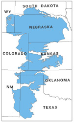
The Ogallala aquifer underlies parts of eight
states. Photo courtesy U.S. Geological Survey.
|
|

|
|
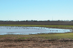
Rain that makes it past the plant root zone is a
key source for recharging the Ogallala aquifer. Photo courtesy Dennis
Gitz.
|
Researchers Study Playa Lakes Over the
Ogallala
By Don
Comis April 2, 2008
Are the tens of thousands of playa lakes that dot the Southern High
Plains key to keeping the Ogallala Aquifer's dwindling waters clean? That's the
question Agricultural Research Service (ARS) plant physiologist
Dennis
Gitz is asking about North America's largest aquifer.
Playas are ephemeral lakes that form when rainwater fills natural clay
depressions in the landscape. Gitz found that this water flows continually
downward, if slowly, into the Ogallala, contributing to its recharge.
The recharge rate for cropland over the Ogallala is negligible, which
is why there is so much concern for this practically finite source of
water.
Part of the playas question is whether the recharge rate is
significant enough for them to be protected with filtering borders of gamagrass
or switchgrass. If so, the grass borders would ensure that playas continue to
add significant amounts of clean water to the Ogallala and help extend its
useful life.
To measure the recharge rate of the Ogallala for both cropland and
playas, Gitz and colleagues from Texas Tech
University are using soil thermometers to track rainwater's downward
movement through soil. The thermometers track rainwater by detecting sudden
changes in temperature where rainwater stops seeping.
The scientists proved the thermometer idea works in a study that
showed a good agreement between thermometer readings and actual water
infiltration readings. Thermometers are much less expensive than other methods
of tracking rainwater infiltration.
Gitz has installed a bank of instruments at 14 playas and is
developing instruments for 16 more. These include instruments for weather
stations, as well as for measuring water levels. He will use data from these
instruments to calculate expected water evaporation rates for comparison to
actual water losses. The difference shows the amount of water that has
infiltrated the soil below the lakes.
If the recharge rate for playas turns out to be negligible, farmers
could consider managing them for rangeland or recreational use.
Read
more about the research in the April 2008 issue of Agricultural
Research magazine.
ARS is the U.S. Department of
Agriculture's chief scientific research agency.