| Latest Drought Information |
| |
Synopsis |
Summary of Impacts |
Climate Summary |
Temperature and Precipitation Outlook
Hydrologic Summary and Outlook |
Related Web Sites |
| |
|
|
| |
...Moderate
Drought Lingers in Union County...
|
| |
| |
| Synopsis |
The New Mexico summer thunderstorm season has come to a gradual end,
just about on schedule. The precipitation focus turns toward the possibility
of tropical moisture intrusions due to the remnants of
a tropical storm or depression. About three out of every five years,
such remnants can work their way northeast into New Mexico from the
Gulf
of California
or
from the
southeast
due
to the westward movement of a hurricane that made landfall along the
Texas Gulf coast. These intrusions are most likely in September, however,
the weather pattern from
early
September
through
early
October
is
generally dominated
by
mostly dry conditions with only isolated convective showers and thunderstorms.
The first true cold fronts of the fall season can also bring showers,
mainly to the eastern and northern parts of the state.
As we transition to autumn, drought concerns are mainly limited to northeast
New Mexico.
The current U.S. Drought Monitor map depiction of drought for New Mexico
can be found at:
http://drought.unl.edu/dm/DM_state.htm?NM,W
|
| Summary of Impacts |
Moisture from summer showers and thunderstorms has allowed any fire related
restrictions to be lifted from all state and federal recreational lands.
The Navajo Nation retains fire restrictions on the reservation in northwest
New Mexico where campfires are permitted only in developed recreation
areas. Smoking and fireworks are prohibited. The Zuni Pueblo entered
restrictions on May 11. Most of the Pueblos in New Mexico remain under
Stage 1 fire restrictions.
|
 |
|
 |
| WFAS Observed Fire Danger Class for Yesterday |
|
CPC Most Recent Day Soil Moisture Anomaly Map |
| |
| Climate Summary |
The near-uniformly dry conditions this spring left several regions with
significant precipitation deficits through the first six months of
this year. Drought conditions extended across much of the southeast
two-thirds of the state by early July. Despite the near normal to abundant
summer precipitation in most areas of the
state,
parts
of
Union County
and
far northeast
Colfax County still reported moderate precipitation deficits by early
September.
A few precipitation statistics for select locations through the first
8 months of 2008:
|
 |
| |
Animation of the drought status in New Mexico
for early January, March, May, July, and September of 2008. |
| |
|
| |
Observed (in.) |
Deficit (in.) |
Percent of Normal |
| Pasamonte |
9.68 |
2.57 |
79 |
| Grenville |
11.02 |
2.41 |
82 |
| Amistad 5SSW |
9.44 |
2.36 |
80 |
| Raton Filter Plant |
9.81 |
4.00 |
71 |
Summer precipitation, June through August, was well
above normal in southwest and south central New Mexico, while the Four
Corners region of San Juan County reported below normal summer rainfall.
Some notable summer precipitation totals and rankings include:
| Tularosa |
9.76 inches |
New summer record (was 8.79 inches in 1988) |
| Winston |
16.34 inches |
New summer record (was 12.69 inches in 2006) |
| Deming |
8.68 inches |
Most since the summer of 1986 (10.42 inches) |
| T or C |
8.89 inches |
Second highest summer total on record |
| Cloudcroft |
19.34 inches |
Third highest summer total on record |
| Fort Bayard |
12.47 inches |
Third highest summer total on record |
| Ruidoso |
15.95 inches |
Fourth highest summer total on record |
|
 |
|

|
| |
Precipitation Estimates and departures
from normal can be generated for a variety of time periods including
the current
day, archived days, the previous month and the calendar year to date. |
| Calendar Year Precipitation for Selected NM Sites |
| |
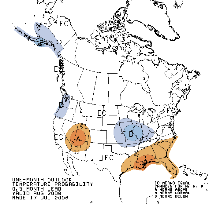
| Precipitation and Temperature Outlooks |
The monsoon season activity of daily scattered showers and thunderstorms
has faded away. The onset of westerly winds aloft tends to bring drier
and cooler air to much of New Mexico.
La Niña conditions, which were primarily responsible for the
meager spring precipitation reported across much of New Mexico, had faded
to ENSO neutral conditions across the equatorial Pacific Ocean regions
by mid summer. ENSO neutral conditions are expected to persist through
the end of 2008. Looking beyond the end of 2008, a historical tendency
for multi-year La Niña episodes would imply that a return to weak
La Niña conditions is possible.
For the latest weather forecast for the northern
two thirds of New Mexico, please see the NWS
WFO Albuquerque Forecast Map.
|
 |
|
 |
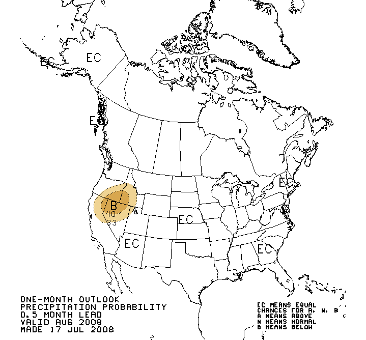
| One- Month CPC Outlooks |
| |
|
|
 |
|
 |
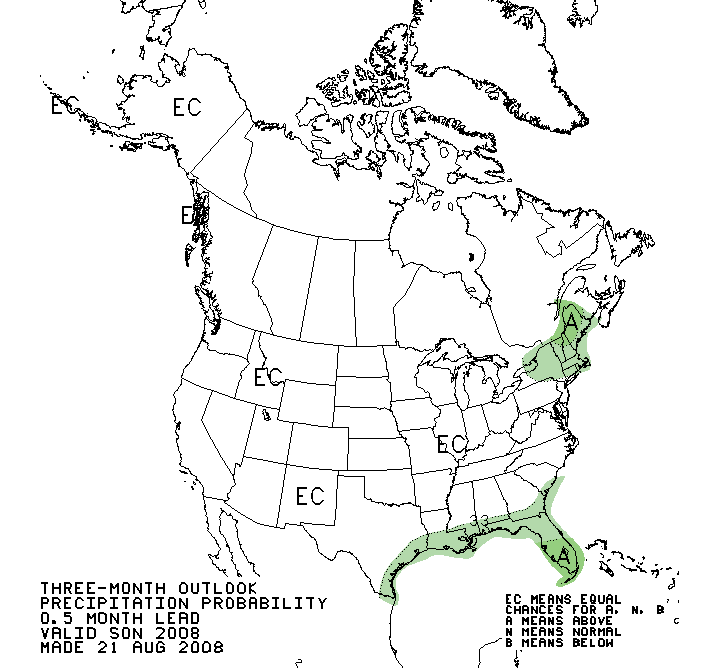
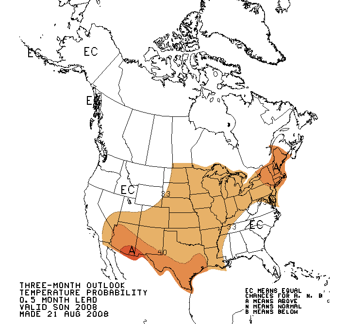
3-Month CPC Outlooks |
| |
| Hydrologic Summary and Outlook |
Reservoir storage is above normal at Abiquiu Lake, El Vado Lake, and
Costilla Lake, while water levels were close to normal at Eagle Nest,
Navajo Lake, and Heron Lake.
Well below normal storage persists at Conchas Lake,
Elephant Butte Lake, Bluewater Lake, Santa Rosa Lake, and Sumner Lake.
|
 |
|
 |
| New Mexico Reservoir Storage Information from
NRCS |
|
New Mexico Water Watch from USGS |
| |
| Related
Web Sites |
| |
| Drought
Monitoring |
|
Drought Indices |
| NWS
ABQ Drought Information Statement (Text Product) |
|
Drought
Indices Explained |
| U.S. Drought Monitor |
|
Crop Moisture Index |
| USGS
Drought Watch |
|
Palmer Drought Severity Index |
| The
National Integrated Drought Information System |
|
Percent of Normal Precipitation |
| USGS
Water Data for New Mexico |
|
SPI
(Standardized Precipitation Index) | Alternate |
| NWS Precipitation Analysis Page |
|
|
| Drought Impacts |
|
External Links and Sites |
| NDMC Drought Impact Reporter |
|
New
Mexico State Engineer Drought Task Force |
| Southwest Area Fire
Information |
|
Water
Supply Forecast |
| Public
Lands Information - New Mexico Fire News |
|
|
| |
|
|
| River
Information |
|
Additional Information |
| NWS
AHPS |
|
NM
Drought Map Archive - April '06 - February '08 |
| USGS
New Mexico Streamflow |
|
New Mexico Precipitation Summaries |
| |
|
Climatology
and Paleoclimatology |
| |
|
Western Region Climate Center |
| |
|
|
 |
| US Seasonal Drought Outlook from the Climate
Prediction Center |
| |
|
|
This
product will be updated in late September or sooner if necessary in response
to significant changes in weather, water supply, or drought conditions. |
| |
| Acknowledgements |
The U.S. Drought Monitor
is a multi-agency effort involving the NOAA National Weather Service and
National Climatic Data Center, the USDA, State and Regional Climate
Centers and the National Drought Mitigation Center. Information for this
statement
has been gather from the NWS and FAA observations sites, state cooperative
extension services, the U.S. Geological Survey and other government agencies. |
| |
| If you have any questions
or comments about this drought information statement, please contact: |
National Weather Service
2341 Clark Carr Loop SE
Albuquerque NM 87106
Phone...505-244-9147
sr-abq.webmaster@noaa.gov
|

 National
Weather Service Weather Forecast Office
National
Weather Service Weather Forecast Office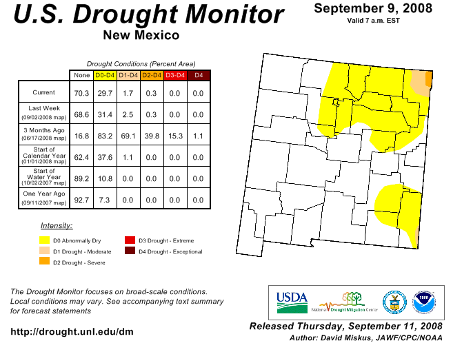

