National Park Service LogoU.S. Department of the InteriorNational Park ServiceNational Park Service
National Park Service:  U.S. Department of the InteriorNational Park Service Arrowhead
Great Sand Dunes National Park and PreserveGreat Sand Dunes and Medano Creek
view map
text size:largestlargernormal
printer friendly
Great Sand Dunes National Park and Preserve
Hiking and Backpacking
View from Star Dune
NPS Photo by Fred Bunch
View of 30 square mile dunefield from Star Dune, the tallest dune at 750' (229m).

Dunes Exploration

Explore any part of the 30 square mile dunefield you wish; there are no designated trails in the sand. A dunes–accessible wheelchair is available for free loan at the Visitor Center. In summer months, plan to hike the dunes in morning or evening to avoid hot sand.


Medano Creek

When there’s water in Medano Creek at the base of the dunes, adults and kids alike love to splash in the stream. Watch for waves in the water, a phenomenon called "surge flow." As mounds of sand form and fall in the creek bed, water surges, similar to the action of waves at a beach. Check current conditions of Medano Creek


The Tallest Dunes

The "High Dune" is neither the highest in elevation nor the tallest in the park, but it looks that way from the main parking lot. It is about 650 feet (198 m) high. Cross the flats and zigzag up the ridgelines to reach it. The 360 degree view is inspirational. From High Dune, the skyrising dune you see to the west is the spectacular Star Dune, rising 750 feet (229 m). It is the tallest dune in North America. To reach it from High Dune, journey another mile and a half up and down across the dunes to its summit.


Eastern Dune Ridge

By high clearance 4WD vehicle, drive to Sand Pit or Castle Creek Picnic Areas. Or, with 2WD vehicle, drive to Point of No Return, then hike 3/4 mile (1.3K) to Sand Pit or 1.5 miles (2K) to Castle Creek. Castle Creek Picnic Area offers an impressively tall, steep dune face. Both areas have access to Medano Creek, which usually flows through autumn in this area. 

 
Forest in Great Sand Dunes National Preserve, Autumn
NPS Photo
Forest in Great Sand Dunes National Preserve

Forested Trails

Montville Nature Trail

In summer, keep this hike as an option for afternoon as an escape from the heat of the dunes. Walk along a shady forested trail named for a late 1800s settlement, comprising 20 houses in its heydey. Rest near the trail’s highpoint, where you’ll find outstanding views of Mt. Herard, the dunes and the valley.

(Please be aware that hunting is permitted in fall and early winter in Great Sand Dunes National Preserve, the mountain portion of the park and preserve. Check with a park ranger for details.)

Mosca Pass Trail

This trail follows a small creek to the summit of a low pass in the Sangre de Cristo mountains, winding through aspen and evergreen forests. Allow 2-3 hours to reach the pass; the trail is 3 1/2 miles (5.7 km) one way. Indians and early settlers used this route for travel into the valley.


Dunes Overlook/Sand Ramp Trail

For a view of the dunes from the foothills of the Sangre de Cristos, begin hiking the Sand Ramp Trail in Loop 2 of the campground. Scenery abounds in all directions. Although only two miles round trip to the overlook, this trek can be extended, as the Sand Ramp trail continues for 11 miles total around the eastern and northern perimeter of the dunes.


Medano Pass 4WD Road

Driving this road requires high clearance 4-wheel drive (not recommended for small sport utility vehicles). A scenic drive any time of the year, it is especially spectacular in fall. Creek crossings can be hazardous in spring and the road is closed when winter conditions create hazards. For those without a 4WD vehicle, consider taking the Oasis 4-wheel drive tour, offered May through October at the Oasis store near the park boundary.

 
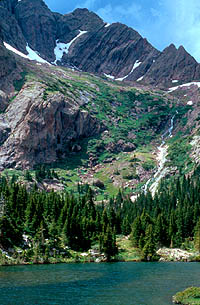
Upper Sand Creek Lake
NPS Photo by Patrick Myers
Upper Sand Creek Lake, Great Sand Dunes National Preserve

Alpine Trails

Medano Lake and Mount Herard

This trailhead is accessed from the Medano Pass 4WD road. Beginning at 10,000’ elevation, the trail climbs 2000’ through lush meadows and forests, ending at an alpine lake just above timberline. For advanced hikers, continue on to the summit of 13,297’ Mount Herard for a spectacular aerial view of the dunes.

Music Pass, Sand Creek Lakes, and Other Alpine Peaks

A longer drive and/or a long hike is required for these destinations. However, the stunning alpine scenery is worth the effort. Check with a ranger for conditions before travel. Snow may block these trails from November into June. The trailhead for Music Pass from the east is accessed from Highway 69, 4.5 miles south of Westcliffe. Turn off Highway 69 to the west at the sign for Music Pass and South Colony Lakes Trailhead. At the "T" junction, turn left onto South Colony Road. At the end of the ranch fence on the right, you’ll see another sign for Music Pass. 2WD drivers should park where the Rainbow Trail crosses Music Pass Road. From here, walk 3.5 miles to the pass. 4WD drivers may drive another 2.5 rough miles to the end of the road. From here, it is just a steep one mile hike to the pass. Music Pass is at treeline, with a great view of the Upper Sand Creek basin. From the pass, hike farther to four alpine lakes, or to any one of the 13,000’ peaks above the basin. "The Essential Guide to Great Sand Dunes National Park and Preserve", available in the Visitor Center bookstore, has climbing information for the peaks. You may also access these lakes and peaks via the Sand Ramp Trail, connecting with the Sand Creek Trail from the west. Check with a ranger for conditions and details by calling the Visitor Center, 719-378-6399.

 
Grasslands west of dunefield
NPS Photo by Patrick Myers
Asters bloom in late summer in the grasslands south and west of the dunes.

Grasslands and Shrublands

The spacious grasslands and shrublands of the national park are the least visited area, yet they contain spectacular wildlife, migrating dunes, panoramic mountain views, and intricate beauty. See details on accessing grasslands in and around the national park.

 
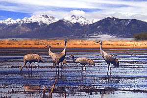
Wetland with Sandhill Cranes
USFWS Photo
Thousands of sandhill cranes migrate through the San Luis Valley in spring and fall, spending a month or two each season in and around valley wetlands.

Wetlands

Wetlands abound in the San Luis Valley, providing refreshing oases for wildlife and people in this high mountain desert. See details on accessing the wetlands in and around Great Sand Dunes National Park.

 
Backpackers at Music Pass
NPS Photo
Backpackers visit with a ranger at Music Pass, Great Sand Dunes National Preserve

Backpacking

The Wilderness Act of 1964 defines wilderness as "untrammeled by man, where man himself is a visitor who does not remain." Over 33,000 acres of Great Sand Dunes National Park and most of Great Sand Dunes National Preserve is legislated wilderness. Here you can hike with the assurance that this striking landscape will remain wild for countless future generations to enjoy--and share in the responsibility for protecting it and yourselves.

Free backcountry permits are required for all overnight backpacking trips. Inquire at the Visitor Center. Please note that permits must be obtained in person during Visitor Center hours: 9 a.m. to 6 p.m. summer; 9 a.m. to 4:30 p.m. fall, spring and winter. Plan to use Leave No Trace guidelines: Pack out everything you bring with you, including your trash and toilet paper. Build no fires; camp stoves are good. Do not trench around your tent. Do not damage vegetation or feed or harass wild animals. You are sharing their habitat. Camp at least 200 feet from any source of water and at least 100 feet from the trail. Stay safe and healthy! Purify all water taken from natural sources. Be prepared for sudden weather changes. Let a responsible friend or family member know where you are and when you will return. Hang or otherwise secure your food and toiletries from black bears.

Designated backcountry sites in the national park are located along the Sand Ramp Trail, in the transition area between the dunefield and the mountains. Slightly more sheltered from wind and lightning than the open dunes, these sites tend to have excellent views and some shade, but some are more than 1 mile from a source of water.

Descriptions of each backpacking site:

BUCK CREEK: 0.5 miles north of Loop 2 in the campground. This site is for families with children who want a short hike into the backcountry.

ESCAPE DUNES: 1.4 miles north of Point of No Return in an open grove of ponderosa pines. The site is near small "escape dunes", that have left the main dunefield and buried and smothered trees, leaving ghostly skeletons behind (a "Ghost Forest"). The vast majority of the pines in this grove are tall, alive, and healthy.

INDIAN GROVE: 2.9 miles north of Point of No Return. Explore the area and look for several ponderosa pines with large scars where American Indians peeled their bark for food and other uses in times past. The Scarred Trees Grove is on the National Register of Historic Sites. This is the most popular backpacking site because it is close to the main dunefield and close to Medano Creek, but it is in a sheltered grove of trees. It is the only site with a solar-composting toilet.

LITTLE MEDANO: 3.9 miles from Point of No Return, or 0.7 miles from Sand Ramp TH (high-clearance 4WD parking only).  This site is situated in montane woodlands below Mount Herard. Little Medano Creek provides an good water source in most years, but may be dry in drought years.

ASPEN: 5.7 miles from Point of No Return, or 2.3 miles from Sand Ramp TH (high-clearance 4WD parking only). Aspen Camp offers incredible views of the entire dunefield from a foothills aspen grove. At 9,240 feet elevation, it is the highest designated backcountry site in the park (backcountry camping is also allowed off-trail in the national preserve; see below).

COLD CREEK: 8.9 miles from Point of No Return, or 5.5 miles from from Sand Ramp TH (high-clearance 4WD parking only). A destination for the more adventurous backpacker, Cold Creek Camp lies in a rugged valley filled with ponderosa pines. Wildlife abounds in this area including elk, deer, bears, and mountain lions.

SAND CREEK: 10.5 miles from Point of No Return, or 7 miles from the Sand Ramp TH (high clearance 4WD parking only). The campsite lies in a beautiful grove of cottonwood trees on the edge of the main dunefield. This is the only backcountry site where campfires are permitted. Collect dead and down wood only, and build your fires in the grate. Be absolutely certain the fire is out before you leave the site.

Camping in the dunes is permitted anywhere in the dunefield outside of the day use area (about 1.5 mile hike minimum over dunes). Offering unmatched views of the night sky and opportunities to observe the nocturnal life on the dunes, you must be prepared for occasional windy weather and thunderstorms.

Camping in Great Sand Dunes National Preserve, the mountainous portion of the park and preserve, is available in most areas off-trail, as long as you are following national preserve regulations. The national preserve is part of the Sangre de Cristo Wilderness area, a federally designated wilderness. You will need a permit from the Visitor Center only if you are accessing the preserve through the national park's main access area. Please Leave No Trace of your visit. Trail access is limited and extra preparedness is required. Hunting is permitted in the national preserve by license and in season - use extra caution if you hike during hunting season! 

Obtain information and your free backpacking permit at the Visitor Center during open hours. Permits are first-come, first-served, and are not available in advance. 

 
Upper Sand Creek Lake  

Did You Know?
Alpine lakes such as Upper Sand Creek Lake are part of the mountain watershed of Great Sand Dunes, and provide a dramatic contrast to the stark dunefield.
more...

Last Updated: March 05, 2008 at 18:36 EST