Research Programs
By Region
By Subject
By Researcher
Publications
Milestone Reports
|
|
Station Map |
Alpena |
Cleveland Central |
Grand Haven Pier |
Saginaw Marker 1 |
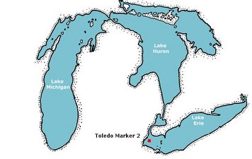
Toledo Marker 2 |
West Lake Erie
Realtime Coastal Observation Network (RECON) Station
Toledo Channel Marker #2
|
| NOTE: Wind speed/direction sensor is malfunctioning. |
Conditions around 10:00 am EDT on Sat, Sep 20, 2008 (14:00 GMT)
|
 Data Plots Data Plots
|
|

| Air Data: | | |
| Wind Speed: | 5.34 kts (2.75 m/s) | R.M.Young Wind Monitor |
| Maximum Wind Speed: | 6.33 kts (3.25 m/s) | R.M.Young Wind Monitor |
| Wind Direction: | 287.7° (WNW) | R.M.Young Wind Monitor |
| Air Temperature: | 67.1 °F (19.5 °C) | CSI Temp Probe |
| | | |
| Engineering Data: | | |
| Solar Panel Voltage: | 15.10 volts | Buoy Electronics |
| Solar Panel Current: | 2.269 amps | Buoy Electronics |
| Battery Voltage: | 13.99 volts | Buoy Electronics |
| Battery Current: | 1.449 amps | Buoy Electronics (neg = discharging) |
| Buoy Current: | -0.664 amps | Buoy Electronics |
| U/W Hub Current: | 0.010 amps | Buoy Electronics |
| | | |
| Signal Strength: | -65.0 dB | RSL at Shore Station |
| Data Throughput Rate: | 1.455 Mbits/sec | FTP Transfer Buoy to Shore |
Last data download at Sat Sep 20 10:09:12 EDT 2008
|
|
|


 Data Plots