| Home >> | Advanced Search >> |
 |
|
Astronaut Photography of Earth - Display Record
STS118-E-9469
Low-resolution Browse Image
(Most browse images are not color adjusted.)Images
Conditions for Use of Images >>Image Transformation Tutorial >> Saving, Color Adjusting, and Printing Images >>
Images to View on Your Computer Now
| File Name | File Size (bytes) | Width | Height | Annotated | Cropped | Purpose | Comments | |
|---|---|---|---|---|---|---|---|---|
| View | STS118-E-9469.JPG | 78137 | 639 | 435 | No | No | ||
| View | STS118-E-9469.JPG | 176868 | 540 | 360 | Yes | Yes | NASA's Earth Observatory web site |
Large Images to Request for Downloading
| File Name | File Size (bytes) | Width | Height | Annotated | Cropped | Purpose | Comments | |
|---|---|---|---|---|---|---|---|---|
| Request | STS118-E-9469.JPG | 466963 | 1000 | 667 | No | Yes | NASA's Earth Observatory web site | |
| Request | STS118-E-9469.JPG | 1346631 | 3032 | 2064 | No | No |
Download a Keyhole Markup Language (KML) file for use in Google Earth.
Electronic Image Data
Camera Files >> No sound file available.Identification
Mission: STS118 Roll: E Frame: 9469 Mission ID on the Film or image: STS118Country or Geographic Name: GREECE
Features: STRAIT OF OTRANTO,ISS
Center Point Latitude: 39.5 Center Point Longitude: 19.8 (Negative numbers indicate south for latitude and west for longitude)
Stereo: (Yes indicates there is an adjacent picture of the same area)
ONC Map ID: JNC Map ID:
Camera
Camera Tilt: High ObliqueCamera Focal Length: 28mm
Camera: E4: Kodak DCS760C Electronic Still Camera
Film: 3060E : 3060 x 2036 pixel CCD, RGBG array.
Quality
Film Exposure:Percentage of Cloud Cover: 10 (0-10)
Nadir
Date: 20070819 (YYYYMMDD)GMT Time: 124023 (HHMMSS)Nadir Point Latitude: 36.9, Longitude: 15.6 (Negative numbers indicate south for latitude and west for longitude)
Nadir to Photo Center Direction: Northeast
Sun Azimuth: 229 (Clockwise angle in degrees from north to the sun measured at the nadir point)
Spacecraft Altitude: 185 nautical miles (343 km)
Sun Elevation Angle: 57 (Angle in degrees between the horizon and the sun, measured at the nadir point)
Orbit Number: 168
Captions
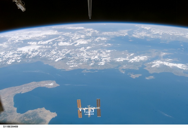
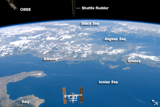
International Space Station from Space Shuttle EndeavourThe crew of the Space Shuttle Endeavour took this spectacular image of the International Space Station during the STS118 mission, August 8–21, 2007. The image was acquired by an astronaut through one of the crew cabin windows, looking back over the length of the Shuttle. Endeavour had undocked from the International Space Station, and the crew had begun late inspection of the orbiter’s Thermal Protection System (wing leading edges, nosecap, and belly tiles) prior to landing. The late inspection is performed using sensors mounted on the Orbiter Boom Sensor System, and the goal is to assess whether micrometeorite or orbiting debris have compromised the Thermal Protection System of the Shuttle while it was docked with the International Space Station.
This oblique (looking at an angle from vertical, rather than straight down towards the Earth) image was acquired almost one hour after late inspection activities had begun. The sensor head of the Orbiter Boom Sensor System is visible at image top left. The entire Space Station is visible at image bottom center, set against the backdrop of the Ionian Sea approximately 330 kilometers below it. Other visible features of the southeastern Mediterranean region include the toe and heel of Italy’s “boot” at image lower left, and the western coastlines of Albania and Greece, which extend across image center. Farther towards the horizon, the Aegean and Black Seas are also visible.
Download Packaged File.
This option downloads the following items, packaged into a single file, if they are available:
- Browse image
- Cataloged information with captions
- Camera file
- Sound file
Server: 2 |
This service is provided by the International Space Station program. |
Recommended Citation: |
||

