| Home >> | Advanced Search >> |
 |
|
Astronaut Photography of Earth - Display Record
ISS010-E-9366

Low-resolution Browse Image
(Most browse images are not color adjusted.)Images
Conditions for Use of Images >>Image Transformation Tutorial >> Saving, Color Adjusting, and Printing Images >>
Images to View on Your Computer Now
| File Name | File Size (bytes) | Width | Height | Annotated | Cropped | Purpose | Comments | |
|---|---|---|---|---|---|---|---|---|
| View | ISS010-E-9366.JPG | 108857 | 639 | 435 | No | No | ||
| View | ISS010-E-9366.JPG | 311126 | 540 | 374 | Yes | Yes | Earth From Space collection | |
| View | ISS010-E-9366.JPG | 975061 | 1000 | 693 | No | Yes | NASA's Earth Observatory web site |
Large Images to Request for Downloading
| File Name | File Size (bytes) | Width | Height | Annotated | Cropped | Purpose | Comments | |
|---|---|---|---|---|---|---|---|---|
| Request | ISS010-E-9366.JPG | 1437518 | 3032 | 2064 | No | No |
Download a Keyhole Markup Language (KML) file for use in Google Earth.
Electronic Image Data
Camera Files >> No sound file available.Identification
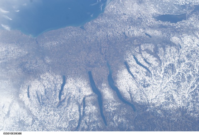
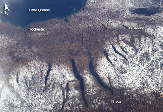
Mission: ISS010 Roll: E Frame: 9366 Mission ID on the Film or image: ISS010Country or Geographic Name: USA-NEW YORK
Features: LAKE ONTARIO,SYRACUSE,SNOW
Center Point Latitude: 43.0 Center Point Longitude: -77.0 (Negative numbers indicate south for latitude and west for longitude)
Stereo: (Yes indicates there is an adjacent picture of the same area)
ONC Map ID: JNC Map ID:
Camera
Camera Tilt: 34Camera Focal Length: 50mm
Camera: E4: Kodak DCS760C Electronic Still Camera
Film: 3060E : 3060 x 2036 pixel CCD, RGBG array.
Quality
Film Exposure:Percentage of Cloud Cover: 10 (0-10)
Nadir
Date: 20041204 (YYYYMMDD)GMT Time: 150114 (HHMMSS)Nadir Point Latitude: 43.5, Longitude: -75.0 (Negative numbers indicate south for latitude and west for longitude)
Nadir to Photo Center Direction: West
Sun Azimuth: 153 (Clockwise angle in degrees from north to the sun measured at the nadir point)
Spacecraft Altitude: 187 nautical miles (346 km)
Sun Elevation Angle: 20 (Angle in degrees between the horizon and the sun, measured at the nadir point)
Orbit Number: 2509
Captions
New York's Finger LakesA late fall snowstorm frosted the hills of the Finger Lakes region of central New York in early December. Shapes of the snow-covered hills are accented by the low Sun angles, and contrast with the darker, finger-shaped lakes filling the region’s valleys. The steep, roughly parallel valleys and hills of the Finger Lakes region were shaped by advancing and retreating ice sheets that were as much as 2 miles deep during the last ice age (2 million years to about 10,000 years ago). River valleys were scoured into deep troughs; many are now filled with lakes. The two largest lakes, Seneca and Cayuga, are so deep that the base of their lakebeds are below sea level.
The cities of Rochester, Syracuse, and Ithaca are included in this field-of-view, taken from the International Space Station. These three cities enjoy large seasonal snowpacks, thanks to the influence of the Great Lakes producing lake-effect snowstorms. Despite its reputation for long winters, the region is balmy compared with the glacial climate present when the landscape was carved. At the time of the greatest ice extent, yearly average temperatures over northern North America were several degrees lower than today.
Download Packaged File.
This option downloads the following items, packaged into a single file, if they are available:
- Browse image
- Cataloged information with captions
- Camera file
- Sound file
Server: 2 |
This service is provided by the International Space Station program. |
Recommended Citation: |
||

