| Home >> | Advanced Search >> |
 |
|
Astronaut Photography of Earth - Display Record
STS100-349-9

Low-resolution Browse Image
(Most browse images are not color adjusted.)Images
Conditions for Use of Images >>Image Transformation Tutorial >> Saving, Color Adjusting, and Printing Images >>
Images to View on Your Computer Now
| File Name | File Size (bytes) | Width | Height | Annotated | Cropped | Purpose | Comments | |
|---|---|---|---|---|---|---|---|---|
| View | STS100-349-9.JPG | 41608 | 515 | 342 | No | No | From ISD CD TIFF images | |
| View | STS100-349-9.JPG | 155969 | 540 | 708 | Yes | Yes | NASA's Earth Observatory web site | |
| View | STS100-349-9.JPG | 2053591 | 2968 | 1980 | No | Yes | NASA's Earth Observatory web site | |
| View | STS100-349-9_2.JPG | 271809 | 400 | 524 | Yes | Yes | Photographic Highlights | Split into two frames |
Large Images to Request for Downloading
| File Name | File Size (bytes) | Width | Height | Annotated | Cropped | Purpose | Comments | |
|---|---|---|---|---|---|---|---|---|
| Request | STS100-349-9.JPG | 899137 | 3070 | 2044 | No | No | From ISD CD TIFF images |
Download a Keyhole Markup Language (KML) file for use in Google Earth.
Electronic Image Data
Camera files only apply to electronic still cameras.No sound file available.
Identification
Mission: STS100 Roll: 349 Frame: 9 Mission ID on the Film or image: STS100Country or Geographic Name: USA-COLORADO
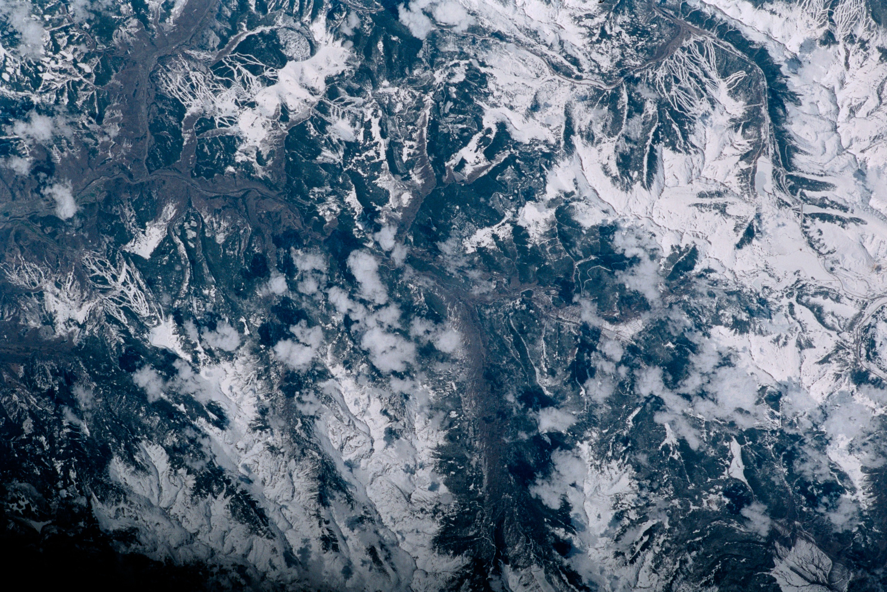
Features: ROCKY MTS., SKI SLOPES, VAIL
Center Point Latitude: 39.5 Center Point Longitude: -106.5 (Negative numbers indicate south for latitude and west for longitude)
Stereo: (Yes indicates there is an adjacent picture of the same area)
ONC Map ID: JNC Map ID:
Camera
Camera Tilt: Low ObliqueCamera Focal Length: mm
Camera: NK: Nikon 35mm film camera
Film:
Quality
Film Exposure:Percentage of Cloud Cover: 10 (0-10)
Nadir
Date: 200104__ (YYYYMMDD)GMT Time: (HHMMSS)Nadir Point Latitude: , Longitude: (Negative numbers indicate south for latitude and west for longitude)
Nadir to Photo Center Direction:
Sun Azimuth: (Clockwise angle in degrees from north to the sun measured at the nadir point)
Spacecraft Altitude: nautical miles (0 km)
Sun Elevation Angle: (Angle in degrees between the horizon and the sun, measured at the nadir point)
Orbit Number:
Captions
The snow-covered ski runs of Vail, Colorado, look like white ribbons in contrast to the dark green forests of the Rocky Mountains. This detailed image is part of a larger view of area ski resorts photographed by the STS-100 Space Shuttle crew in April 2001.In the complete image, much of I-70 and U.S. Highway 24 can be distinguished. The numerous ski runs of Vail are in the upper left of the photo and Copper Mountain Resort is in the upper right.
Download Packaged File.
This option downloads the following items, packaged into a single file, if they are available:
- Browse image
- Cataloged information with captions
- Camera file
- Sound file
Server: 2 |
This service is provided by the International Space Station program. |
Recommended Citation: |
||

