| Home >> | Advanced Search >> |
 |
|
Astronaut Photography of Earth - Display Record
ISS004-E-8852
Low-resolution Browse Image
(Most browse images are not color adjusted.)Images
Conditions for Use of Images >>Image Transformation Tutorial >> Saving, Color Adjusting, and Printing Images >>
Images to View on Your Computer Now
| File Name | File Size (bytes) | Width | Height | Annotated | Cropped | Purpose | Comments | |
|---|---|---|---|---|---|---|---|---|
| View | ISS004-E-8852.JPG | 64905 | 540 | 405 | Yes | Yes | NASA's Earth Observatory web site | |
| View | ISS004-E-8852.JPG | 107473 | 639 | 435 | No | No | From STIC, color adjusted | |
| View | ISS004-E-8852_2.JPG | 254662 | 368 | 540 | Photographic Highlights | 540 px resized images | ||
| View | ISS004-E-8852.JPG | 415132 | 523 | 768 | Photographic Highlights | actual files used | ||
| View | ISS004-E-8852.JPG | 1142934 | 3032 | 2064 | No | No | NASA's Earth Observatory web site |
Large Images to Request for Downloading
| File Name | File Size (bytes) | Width | Height | Annotated | Cropped | Purpose | Comments | |
|---|---|---|---|---|---|---|---|---|
| Request | ISS004-E-8852.JPG | 1142934 | 3032 | 2064 | No | No | Earth From Space collection | |
| Request | ISS004-E-8852.JPG | 1142934 | 3032 | 2064 | No | No | From STIC, color adjusted |
Download a Keyhole Markup Language (KML) file for use in Google Earth.
Electronic Image Data
Camera Files >> No sound file available.Identification
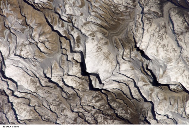
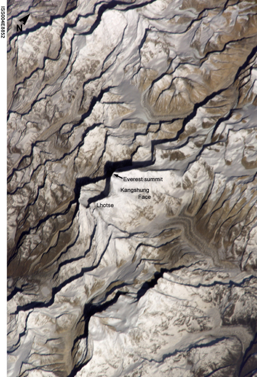
Mission: ISS004 Roll: E Frame: 8852 Mission ID on the Film or image: ISS004Country or Geographic Name: CHINA
Features: MOUNT EVEREST, LHOTSE PEAK
Center Point Latitude: 28.0 Center Point Longitude: 86.5 (Negative numbers indicate south for latitude and west for longitude)
Stereo: (Yes indicates there is an adjacent picture of the same area)
ONC Map ID: JNC Map ID:
Camera
Camera Tilt: 50Camera Focal Length: 800mm
Camera: E4: Kodak DCS760C Electronic Still Camera
Film: 3060E : 3060 x 2036 pixel CCD, RGBG array.
Quality
Film Exposure:Percentage of Cloud Cover: 10 (0-10)
Nadir
Date: 20020320 (YYYYMMDD)GMT Time: 014419 (HHMMSS)Nadir Point Latitude: 29.9, Longitude: 90.2 (Negative numbers indicate south for latitude and west for longitude)
Nadir to Photo Center Direction: Southwest
Sun Azimuth: 103 (Clockwise angle in degrees from north to the sun measured at the nadir point)
Spacecraft Altitude: 213 nautical miles (394 km)
Sun Elevation Angle: 21 (Angle in degrees between the horizon and the sun, measured at the nadir point)
Orbit Number: 3016
Captions
Astronaut Dan Bursch, a member of the Expedition 4 crew on the International Space Station, observed Mt. Everest in late March 2002. This detailed image of Everest, the highest (29,035 feet, 8850 meters) mountain in the world, shows early morning light on the eastern Kangshung Face. The mountains appear to jump out of the picture because the image was taken with low sunlight using an electronic still camera equipped with an 800 mm lens. Astronaut Bursch describes passing over Mt. Everest as part of his 120-day report, which can be viewed at http://earthobservatory.nasa.gov/cgi-bin/redirect?http://spaceflight.nasa.gov/station/crew/exp4/120days.html.Other images of Everest can be viewed from an interactive tutorial, Find Mt. Everest From Space (< href="http://earthobservatory.nasa.gov/cgi-bin/redirect?http://eol.jsc.nasa.gov/education/Everest/default.htm">http://eol.jsc.nasa.gov/education/Everest/default.htm). The tutorial features astronaut photographs of the Himalayas, interactive graphics that illustrate key geographic features for locating Mt. Everest, and information on the geology of the region. The lesson concludes with a test of your ability to identify Everest in different photographs taken from the Space Shuttle.
Download Packaged File.
This option downloads the following items, packaged into a single file, if they are available:
- Browse image
- Cataloged information with captions
- Camera file
- Sound file
Server: 2 |
This service is provided by the International Space Station program. |
Recommended Citation: |
||

