| Home >> | Advanced Search >> |
 |
|
Astronaut Photography of Earth - Display Record
ISS017-E-8188
Low-resolution Browse Image
(Most browse images are not color adjusted.)Images
Conditions for Use of Images >>Image Transformation Tutorial >> Saving, Color Adjusting, and Printing Images >>
Images to View on Your Computer Now
| File Name | File Size (bytes) | Width | Height | Annotated | Cropped | Purpose | Comments | |
|---|---|---|---|---|---|---|---|---|
| View | ISS017-E-8188.JPG | 41277 | 639 | 437 | No | No | ||
| View | ISS017-E-8188.JPG | 193788 | 540 | 396 | Yes | Yes | NASA's Earth Observatory web site |
Large Images to Request for Downloading
| File Name | File Size (bytes) | Width | Height | Annotated | Cropped | Purpose | Comments | |
|---|---|---|---|---|---|---|---|---|
| Request | ISS017-E-8188.JPG | 668073 | 1000 | 734 | No | Yes | NASA's Earth Observatory web site | |
| Request | ISS017-E-8188.JPG | 961930 | 3072 | 2098 | No | No |
Download a Keyhole Markup Language (KML) file for use in Google Earth.
Electronic Image Data
Camera Files >> No sound file available.Identification
Mission: ISS017 Roll: E Frame: 8188 Mission ID on the Film or image: ISS017Country or Geographic Name: USA-FLORIDA
Features: DRY TORTUGAS, FT. JEFFERSON
Center Point Latitude: 24.6 Center Point Longitude: -82.9 (Negative numbers indicate south for latitude and west for longitude)
Stereo: (Yes indicates there is an adjacent picture of the same area)
ONC Map ID: JNC Map ID:
Camera
Camera Tilt: 9Camera Focal Length: 800mm
Camera: N2: Nikon D2Xs
Film: 4288E : 4288 x 2848 pixel CMOS sensor, RGBG imager color filter.
Quality
Film Exposure:Percentage of Cloud Cover: 10 (0-10)
Nadir
Date: 20080529 (YYYYMMDD)GMT Time: 214518 (HHMMSS)Nadir Point Latitude: 24.1, Longitude: -82.9 (Negative numbers indicate south for latitude and west for longitude)
Nadir to Photo Center Direction: North
Sun Azimuth: 282 (Clockwise angle in degrees from north to the sun measured at the nadir point)
Spacecraft Altitude: 183 nautical miles (339 km)
Sun Elevation Angle: 31 (Angle in degrees between the horizon and the sun, measured at the nadir point)
Orbit Number: 2564
Captions
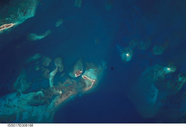
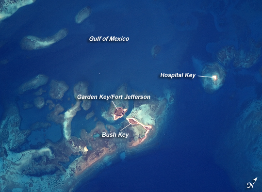
Dry Tortugas, FloridaThe Dry Tortugas are a group of islands located approximately 75 miles west of Key West, Florida; they form the western end of the Florida Keys in the Gulf of Mexico. Like the Keys, the Dry Tortugas are formed primarily of coral reefs that overlie older limestone formations. The islands became known to Europeans as the “Dry Tortugas” upon discovery by Ponce de Leon in 1513. Tortugas means “turtles” in Spanish, and the islands are “dry,” as no fresh water is found on them. From the air, the islands present an atoll-like arrangement, however no central volcanic structure is present. The islands are only accessible by boat or seaplane; they have been designated the Dry Tortugas National Park.
This astronaut photograph highlights three islands in the group: Bush Key, Hospital Key, and Garden Key, which is the site of Fort Jefferson. Fort Jefferson is a Civil War-era fort, perhaps most notable for being the prison of Dr. Samuel Mudd, who set the broken leg of John Wilkes Booth following Booth’s assassination of President Lincoln. The fort itself is currently undergoing extensive restoration to prevent collapse of the hexagonal outer walls (image left). The islands stand out due to brown and light tan carbonate sands visible above the Gulf of Mexico water surface. Light blue-green irregular masses in the image surrounding the islands are coral reef tops visible below the water surface.
Download Packaged File.
This option downloads the following items, packaged into a single file, if they are available:
- Browse image
- Cataloged information with captions
- Camera file
- Sound file
Server: 2 |
This service is provided by the International Space Station program. |
Recommended Citation: |
||

