| Home >> | Advanced Search >> |
 |
|
Astronaut Photography of Earth - Display Record
ISS004-E-7999

Low-resolution Browse Image
(Most browse images are not color adjusted.)Images
Conditions for Use of Images >>Image Transformation Tutorial >> Saving, Color Adjusting, and Printing Images >>
Images to View on Your Computer Now
| File Name | File Size (bytes) | Width | Height | Annotated | Cropped | Purpose | Comments | |
|---|---|---|---|---|---|---|---|---|
| View | ISS004-E-7999_2.JPG | 61751 | 400 | 272 | No | No | Photographic Highlights | From STIC, color adjusted |
| View | ISS004-E-7999.JPG | 90730 | 540 | 604 | Yes | Yes | NASA's Earth Observatory web site | |
| View | ISS004-E-7999.JPG | 99161 | 639 | 435 | No | No | From STIC, color adjusted | |
| View | ISS004-E-7999_2.JPG | 343607 | 436 | 540 | Photographic Highlights | 540 px resized images | ||
| View | ISS004-E-7999.JPG | 654624 | 620 | 768 | Photographic Highlights | actual files used | ||
| View | ISS004-E-7999.JPG | 1335591 | 3032 | 2064 | No | No | NASA's Earth Observatory web site |
Large Images to Request for Downloading
| File Name | File Size (bytes) | Width | Height | Annotated | Cropped | Purpose | Comments | |
|---|---|---|---|---|---|---|---|---|
| Request | ISS004-E-7999.JPG | 1335591 | 3032 | 2064 | No | No | Earth From Space collection | |
| Request | ISS004-E-7999_2.JPG | 1335591 | 3032 | 2064 | ||||
| Request | ISS004-E-7999.JPG | 1586789 | 3032 | 2064 | No | No | From STIC, color adjusted |
Download a Keyhole Markup Language (KML) file for use in Google Earth.
Electronic Image Data
Camera Files >> No sound file available.Identification
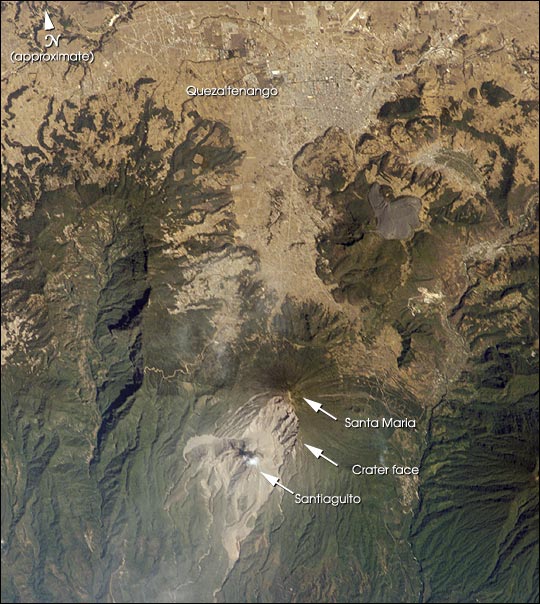
Mission: ISS004 Roll: E Frame: 7999 Mission ID on the Film or image: ISS004Country or Geographic Name: GUATEMALA
Features: SANTA MARIA VOLCANO, SMOKE
Center Point Latitude: 15.0 Center Point Longitude: -91.5 (Negative numbers indicate south for latitude and west for longitude)
Stereo: (Yes indicates there is an adjacent picture of the same area)
ONC Map ID: JNC Map ID:
Camera
Camera Tilt: High ObliqueCamera Focal Length: 400mm
Camera: E4: Kodak DCS760C Electronic Still Camera
Film: 3060E : 3060 x 2036 pixel CCD, RGBG array.
Quality
Film Exposure:Percentage of Cloud Cover: 10 (0-10)
Nadir
Date: 20020217 (YYYYMMDD)GMT Time: 164104 (HHMMSS)Nadir Point Latitude: 20.9, Longitude: -86.7 (Negative numbers indicate south for latitude and west for longitude)
Nadir to Photo Center Direction: Southwest
Sun Azimuth: 147 (Clockwise angle in degrees from north to the sun measured at the nadir point)
Spacecraft Altitude: 205 nautical miles (380 km)
Sun Elevation Angle: 52 (Angle in degrees between the horizon and the sun, measured at the nadir point)
Orbit Number: 2542
Captions
The eruption of Santa Maria volcano in 1902 was one of the largest eruptions of the 20th century, forming a large crater on the mountain’s southwest flank. Since 1922, a lava-dome complex, Santiaguito, has been forming in the 1902 crater. Growth of the dome has produced pyroclastic flows as recently as the 2001—they can be identified in this image. The city of Quezaltenango (approximately 90,000 people in 1989) sits below the 3772 m summit. The volcano is considered dangerous because of the possibility of a dome collapse such as one that occurred in 1929, which killed about 5000 people. A second hazard results from the flow of volcanic debris into rivers south of Santiaguito, which can lead to catastrophic flooding and mud flows.Download Packaged File.
This option downloads the following items, packaged into a single file, if they are available:
- Browse image
- Cataloged information with captions
- Camera file
- Sound file
Server: 2 |
This service is provided by the International Space Station program. |
Recommended Citation: |
||

