| Home >> | Advanced Search >> |
 |
|
Astronaut Photography of Earth - Display Record
ISS017-E-7156
Low-resolution Browse Image
(Most browse images are not color adjusted.)Images
Conditions for Use of Images >>Image Transformation Tutorial >> Saving, Color Adjusting, and Printing Images >>
Images to View on Your Computer Now
| File Name | File Size (bytes) | Width | Height | Annotated | Cropped | Purpose | Comments | |
|---|---|---|---|---|---|---|---|---|
| View | ISS017-E-7156.JPG | 64150 | 640 | 436 | No | No | ||
| View | ISS017-E-7156.JPG | 225069 | 540 | 345 | Yes | Yes | NASA's Earth Observatory web site |
Large Images to Request for Downloading
| File Name | File Size (bytes) | Width | Height | Annotated | Cropped | Purpose | Comments | |
|---|---|---|---|---|---|---|---|---|
| Request | ISS017-E-7156.JPG | 492793 | 3032 | 2065 | No | No | ||
| Request | ISS017-E-7156.JPG | 587685 | 1000 | 639 | No | Yes | NASA's Earth Observatory web site |
Electronic Image Data
Camera Files >> No sound file available.Identification
Complete identification information has not yet been included in the database.Captions
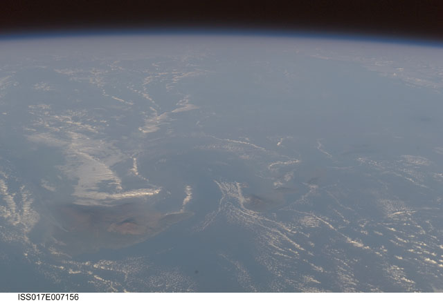
For 25 years, Kilauea volcano on Hawai’i’s Big Island has been erupting continuously. Recent explosive activity that started in March 2008 is producing increased emissions of sulfur dioxide (SO2). These emissions result in a widespread caustic volcanic fog – known as vog - that, depending on local winds, drifts as much as 200 miles up the volcanic chain, burning throats and eyes, and inducing asthma attacks as far away as Honolulu, on the island of Oahu.An oblique view of the Hawaiian islands taken from the International Space Station - viewed looking towards the southwest, rather than “straight down” relative to the Station - on a hazy spring day includes a regional view of three volcanic plumes from Kilauea that contribute to the vog: the plume from Halema‘uma‘u crater near the summit, a plume from Pu’u O’o vent along the east rift, and a plume from where lava enters the ocean on the coast outside of the park boundaries. At the time this image was taken, doctors throughout the state of Hawaii were reporting an increased caseload of people with respiratory problems.
Aside from the vog, this image captures cloud formations indicative of both the large-scale air flow and the local wind patterns around the islands. The parallel lines of clouds aligned roughly northeast to southwest reveal the direction of the region's prevailing trade winds; that flow is disrupted around the islands (between Hawai'i and Maui, image right), and further influenced by the local land/sea breeze which at that time had driven the cloud formations offshore and circling the islands. In addition to the Kilauea plumes, the volcanoes of Mauna Loa and Mauna Kea are also visible on the island of Hawai'i (image left). The uninhabited island of Kaho’olawe is just visible to the southwest of Maui.
Download Packaged File.
This option downloads the following items, packaged into a single file, if they are available:
- Browse image
- Cataloged information with captions
- Camera file
- Sound file
Server: 2 |
This service is provided by the International Space Station program. |
Recommended Citation: |
||

