| Home >> | Advanced Search >> |
 |
|
Astronaut Photography of Earth - Display Record
ISS013-E-71473
Low-resolution Browse Image
(Most browse images are not color adjusted.)Images
Conditions for Use of Images >>Image Transformation Tutorial >> Saving, Color Adjusting, and Printing Images >>
Images to View on Your Computer Now
| File Name | File Size (bytes) | Width | Height | Annotated | Cropped | Purpose | Comments | |
|---|---|---|---|---|---|---|---|---|
| View | ISS013-E-71473.JPG | 86792 | 639 | 435 | No | No | ||
| View | ISS013-E-71473.JPG | 158317 | 540 | 405 | Yes | Yes | NASA's Earth Observatory web site |
Large Images to Request for Downloading
| File Name | File Size (bytes) | Width | Height | Annotated | Cropped | Purpose | Comments | |
|---|---|---|---|---|---|---|---|---|
| Request | ISS013-E-71473.JPG | 1307566 | 3032 | 2064 | No | No |
Download a Keyhole Markup Language (KML) file for use in Google Earth.
Electronic Image Data
Camera Files >> No sound file available.Identification
Mission: ISS013 Roll: E Frame: 71473 Mission ID on the Film or image: ISS013Country or Geographic Name: CARIBBEAN SEA
Features: BAJO NUEVO REEF, SURFACTANTS
Center Point Latitude: 15.9 Center Point Longitude: -78.7 (Negative numbers indicate south for latitude and west for longitude)
Stereo: (Yes indicates there is an adjacent picture of the same area)
ONC Map ID: JNC Map ID:
Camera
Camera Tilt: High ObliqueCamera Focal Length: 800mm
Camera: E4: Kodak DCS760C Electronic Still Camera
Film: 3060E : 3060 x 2036 pixel CCD, RGBG array.
Quality
Film Exposure:Percentage of Cloud Cover: 10 (0-10)
Nadir
Date: 20060827 (YYYYMMDD)GMT Time: 193110 (HHMMSS)Nadir Point Latitude: 18.6, Longitude: -74.9 (Negative numbers indicate south for latitude and west for longitude)
Nadir to Photo Center Direction: Southwest
Sun Azimuth: 262 (Clockwise angle in degrees from north to the sun measured at the nadir point)
Spacecraft Altitude: 186 nautical miles (344 km)
Sun Elevation Angle: 53 (Angle in degrees between the horizon and the sun, measured at the nadir point)
Orbit Number: 446
Captions
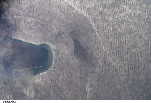
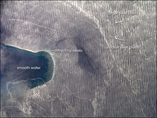
Wave Patterns Near Bajo Nuevo Reef, Caribbean Sea:In these images captured by International Space Station astronauts on August 27, 2006, bright sunlight glinting off the western Caribbean Sea reveals intersecting wave patterns and oily surfactants on the surface waters around Bajo Nuevo Reef. Bajo Nuevo is a collection of small islets arranged into two U-shaped cays, low islands made of coral or sand. This pair of images (see also ISS013-E-71468) shows the easternmost of the two cays (also known as “keys”) and surrounding waters.
This image shows a wide area of the sea around the cay, which encloses a lagoon. Within the lagoon, the water is calmer, and the submerged reef makes a bright blue outline on the downwind side of the islands. Surrounding the lagoon, silvery ocean swells from slightly different directions crisscross the surface. The swells are generally from the east, coming from the direction of the prevailing winds (generally right to left in this image).
The detailed view (see also ISS013-E-71468) reveals the small, low islands that fringe the upwind side of the lagoon. These islands seem dwarfed by wave swells, which almost appear to wash over them. Superimposed on the regular swell pattern are thin ribbons and zones of highly reflective surfactants, chemicals such as natural or synthetic oils that change the water’s surface tension. The surfactants trace additional water dynamics around the edges of the reef, following swirling eddies. The dark, rod-shaped object near upper right is likely a ship that navigated into the reef’s shoals. It appears to be trailing an oily substance, which makes an iridescent ribbon along the south side of the lagoon.
The very bright appearance of the Caribbean Sea in these images results from sunglint. Sunglint occurs when the Sun’s light bounces off the ocean’s surface and directly back into a satellite sensor’s field of view or a camera’s lens. While sunglint can create a washed-out appearance to the surface in some situations, it may also reveal details that aren’t visible in other lighting conditions. For example, in many space-based images, the ocean surface appears as a flat, nearly featureless blue expanse.
Download Packaged File.
This option downloads the following items, packaged into a single file, if they are available:
- Browse image
- Cataloged information with captions
- Camera file
- Sound file
Server: 2 |
This service is provided by the International Space Station program. |
Recommended Citation: |
||

