| Home >> | Advanced Search >> |
 |
|
Astronaut Photography of Earth - Display Record
ISS013-E-6947

Low-resolution Browse Image
(Most browse images are not color adjusted.)Images
Conditions for Use of Images >>Image Transformation Tutorial >> Saving, Color Adjusting, and Printing Images >>
Images to View on Your Computer Now
| File Name | File Size (bytes) | Width | Height | Annotated | Cropped | Purpose | Comments | |
|---|---|---|---|---|---|---|---|---|
| View | ISS013-E-6947.JPG | 63250 | 639 | 435 | No | No | ||
| View | ISS013-E-6947.JPG | 240783 | 540 | 356 | Yes | Yes | NASA's Earth Observatory web site |
Large Images to Request for Downloading
| File Name | File Size (bytes) | Width | Height | Annotated | Cropped | Purpose | Comments | |
|---|---|---|---|---|---|---|---|---|
| Request | ISS013-E-6947.JPG | 741227 | 1000 | 660 | No | Yes | NASA's Earth Observatory web site | |
| Request | ISS013-E-6947.JPG | 1055337 | 3032 | 2064 | No | No |
Download a Keyhole Markup Language (KML) file for use in Google Earth.
Electronic Image Data
Camera Files >> No sound file available.Identification
Mission: ISS013 Roll: E Frame: 6947 Mission ID on the Film or image: ISS013Country or Geographic Name: ARGENTINA
Features: VIEDMA GLACIER,MT. FITZROY
Center Point Latitude: -49.5 Center Point Longitude: -73.0 (Negative numbers indicate south for latitude and west for longitude)
Stereo: (Yes indicates there is an adjacent picture of the same area)
ONC Map ID: JNC Map ID:
Camera
Camera Tilt: 28Camera Focal Length: 800mm
Camera: E4: Kodak DCS760C Electronic Still Camera
Film: 3060E : 3060 x 2036 pixel CCD, RGBG array.
Quality
Film Exposure:Percentage of Cloud Cover: 10 (0-10)
Nadir
Date: 20060412 (YYYYMMDD)GMT Time: 193838 (HHMMSS)Nadir Point Latitude: -51.2, Longitude: -73.3 (Negative numbers indicate south for latitude and west for longitude)
Nadir to Photo Center Direction: North
Sun Azimuth: 316 (Clockwise angle in degrees from north to the sun measured at the nadir point)
Spacecraft Altitude: 191 nautical miles (354 km)
Sun Elevation Angle: 20 (Angle in degrees between the horizon and the sun, measured at the nadir point)
Orbit Number: 2285
Captions
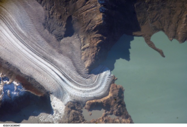
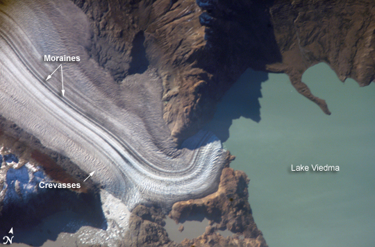
Viedma Glacier, ArgentinaThe icefields of Patagonia, located at the southern end of South America, are the largest masses of ice in the temperate Southern Hemisphere (approximately 55,000 square kilometers). The icefields contain numerous valley glaciers that terminate in meltwater-fed lakes. These are known as “calving” glaciers, as they lose mass when large ice chunks collapse from the terminus—or end—of the glacier. These newly separated chunks of ice are then free to float away, much like ice cubes in a punch bowl.
The terminus of the Viedma Glacier, approximately 2 kilometers across where it enters Lake Viedma, is shown in this astronaut photograph. Moraines are accumulations of soil and rock debris that form along the sides and front of a glacier as it flows across the landscape (much like a bulldozer). Independent valley glaciers can merge together as they flow down slope, and the moraines become entrained in the center of the new ice mass. These medial moraines are visible as dark parallel lines within the white central mass of the glacier (image center and left). Crevasses—oriented at right angles to the medial moraines—are also visible in the grey-brown ice along the sides of the glacier. The canyon-like crevasses form as a result of stress between the slower moving ice along the valley sides (where there is greater friction) and the more rapidly moving ice in the center of the glacier. Calving of ice from the southwestern fork of the glacier terminus is visible at image lower left.
As they respond to regional climate change, the Patagonian glaciers are closely monitored using remotely sensed data. Scientists compare series of images collected over time to monitor the change in ice extent and position. Scientists have also estimated changes in volume using topographic data from NASA’s Shuttle Radar Topography Mission. The Global Land Ice Measurements from Space (GLIMS) Website is an excellent resource for glacier-monitoring information.
Download Packaged File.
This option downloads the following items, packaged into a single file, if they are available:
- Browse image
- Cataloged information with captions
- Camera file
- Sound file
Server: 2 |
This service is provided by the International Space Station program. |
Recommended Citation: |
||

