| Home >> | Advanced Search >> |
 |
|
Astronaut Photography of Earth - Display Record
ISS014-E-6812
Low-resolution Browse Image
(Most browse images are not color adjusted.)Images
Conditions for Use of Images >>Image Transformation Tutorial >> Saving, Color Adjusting, and Printing Images >>
Images to View on Your Computer Now
| File Name | File Size (bytes) | Width | Height | Annotated | Cropped | Purpose | Comments | |
|---|---|---|---|---|---|---|---|---|
| View | ISS014-E-6812.JPG | 57225 | 639 | 435 | No | No | ||
| View | ISS014-E-6812.JPG | 290141 | 540 | 354 | Yes | Yes | NASA's Earth Observatory web site |
Large Images to Request for Downloading
| File Name | File Size (bytes) | Width | Height | Annotated | Cropped | Purpose | Comments | |
|---|---|---|---|---|---|---|---|---|
| Request | ISS014-E-6812.JPG | 881042 | 1000 | 656 | No | Yes | NASA's Earth Observatory web site | |
| Request | ISS014-E-6812.JPG | 1079084 | 3032 | 2064 | No | No |
Download a Keyhole Markup Language (KML) file for use in Google Earth.
Electronic Image Data
Camera Files >> No sound file available.Identification
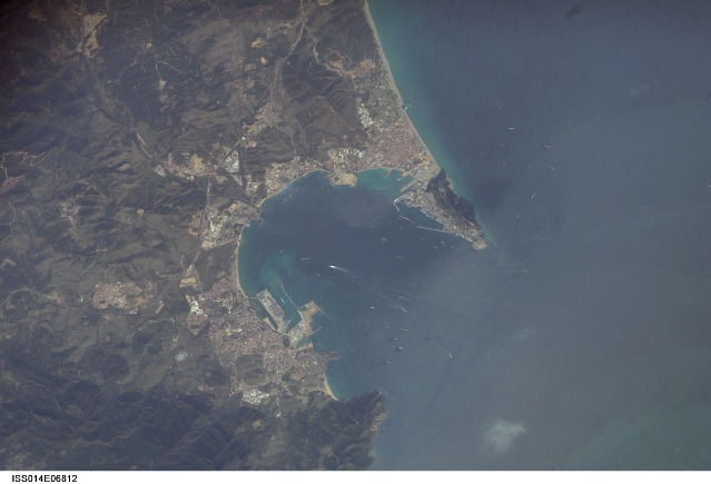
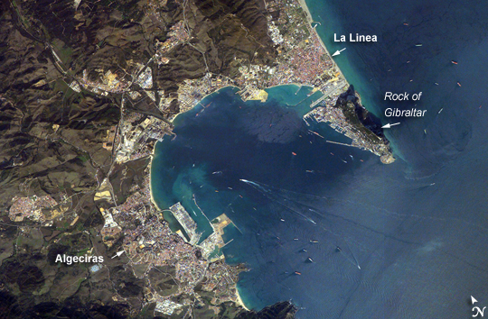
Mission: ISS014 Roll: E Frame: 6812 Mission ID on the Film or image: ISS014Country or Geographic Name: SPAIN
Features: GIBRALTAR, ALGECIRAS, SHIPS
Center Point Latitude: 36.2 Center Point Longitude: -5.4 (Negative numbers indicate south for latitude and west for longitude)
Stereo: (Yes indicates there is an adjacent picture of the same area)
ONC Map ID: JNC Map ID:
Camera
Camera Tilt: 35Camera Focal Length: 400mm
Camera: E4: Kodak DCS760C Electronic Still Camera
Film: 3060E : 3060 x 2036 pixel CCD, RGBG array.
Quality
Film Exposure:Percentage of Cloud Cover: 10 (0-10)
Nadir
Date: 20061030 (YYYYMMDD)GMT Time: 141532 (HHMMSS)Nadir Point Latitude: 38.2, Longitude: -4.7 (Negative numbers indicate south for latitude and west for longitude)
Nadir to Photo Center Direction: South
Sun Azimuth: 218 (Clockwise angle in degrees from north to the sun measured at the nadir point)
Spacecraft Altitude: 180 nautical miles (333 km)
Sun Elevation Angle: 29 (Angle in degrees between the horizon and the sun, measured at the nadir point)
Orbit Number: 1452
Captions
Gibraltar Bay, Western Mediterranean Sea:Gibraltar Bay, located near the southernmost tip of the Iberian Peninsula, is the central feature of this astronaut photograph. The famous Rock of Gibraltar that forms the northeastern border of the bay is formed of Jurassic-era seafloor sediments that solidified into limestone, a rock formed mostly of the mineral calcite, which is found in the shells of sea creatures. The limestone was subsequently lifted above the ocean surface when the African and Eurasian tectonic plates collided. The cities of La Linea and Algeciras bordering the bay, together with petroleum-processing facilities along the northern shoreline, are part of Spain, whereas the city of Gibraltar itself (to the west of and including the Rock) is under the jurisdiction of the United Kingdom.
The protected waters of Gibraltar Bay and its location close to Africa and the Strait of Gibraltar (the gateway between the Atlantic Ocean and the Mediterranean Sea), contribute to the region’s past and current strategic and economic importance. Numerous ships and several ship wakes are visible within the bay; the majority of these are freighters and cargo tankers accessing the petroleum facilities. Ships nearer to the Rock of Gibraltar are more likely cruise ships, as Gibraltar is a popular destination for tourists. Partial sunglint (light reflected directly back to the camera onboard the International Space Station) within the bay highlights surface water roughened by winds funneled into the bay by the surrounding highlands. One such area is visible directly to the west of La Linea.
Download Packaged File.
This option downloads the following items, packaged into a single file, if they are available:
- Browse image
- Cataloged information with captions
- Camera file
- Sound file
Server: 2 |
This service is provided by the International Space Station program. |
Recommended Citation: |
||

