| Home >> | Advanced Search >> |
 |
|
Astronaut Photography of Earth - Display Record
ISS004-E-6737

Low-resolution Browse Image
(Most browse images are not color adjusted.)Images
Conditions for Use of Images >>Image Transformation Tutorial >> Saving, Color Adjusting, and Printing Images >>
Images to View on Your Computer Now
| File Name | File Size (bytes) | Width | Height | Annotated | Cropped | Purpose | Comments | |
|---|---|---|---|---|---|---|---|---|
| View | ISS004-E-6737_2.JPG | 45822 | 400 | 272 | No | Photographic Highlights | From STIC, color adjusted | |
| View | ISS004-E-6737.JPG | 108764 | 639 | 435 | No | No | From STIC, color adjusted | |
| View | ISS004-E-6737_2.JPG | 154849 | 540 | 1256 | Yes | Yes | NASA's Earth Observatory web site | |
| View | ISS004-E-6737_3.JPG | 398277 | 540 | 1256 | Yes | Yes | ||
| View | ISS004-E-6737.JPG | 1296111 | 3032 | 2064 | No | No | NASA's Earth Observatory web site |
Large Images to Request for Downloading
| File Name | File Size (bytes) | Width | Height | Annotated | Cropped | Purpose | Comments | |
|---|---|---|---|---|---|---|---|---|
| Request | ISS004-E-6737.JPG | 1296111 | 3032 | 2064 | No | No | From STIC, color adjusted |
Download a Keyhole Markup Language (KML) file for use in Google Earth.
Electronic Image Data
Camera Files >> No sound file available.Identification
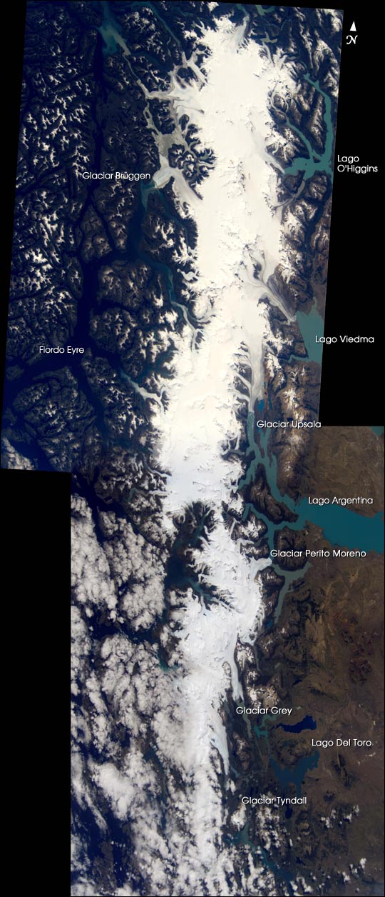
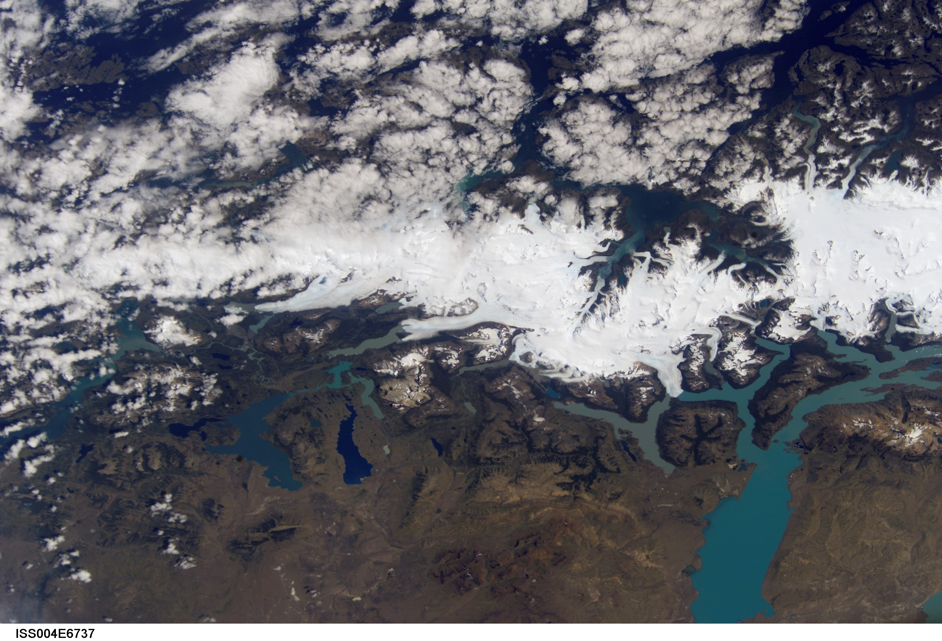
Mission: ISS004 Roll: E Frame: 6737 Mission ID on the Film or image: ISS004Country or Geographic Name: ARGENTINA
Features: SOUTHERN PATAGONIA, GLACIERS
Center Point Latitude: -50.5 Center Point Longitude: -73.0 (Negative numbers indicate south for latitude and west for longitude)
Stereo: (Yes indicates there is an adjacent picture of the same area)
ONC Map ID: JNC Map ID:
Camera
Camera Tilt: 23Camera Focal Length: 80mm
Camera: E4: Kodak DCS760C Electronic Still Camera
Film: 3060E : 3060 x 2036 pixel CCD, RGBG array.
Quality
Film Exposure:Percentage of Cloud Cover: 10 (0-10)
Nadir
Date: 20020122 (YYYYMMDD)GMT Time: 185954 (HHMMSS)Nadir Point Latitude: -51.8, Longitude: -73.8 (Negative numbers indicate south for latitude and west for longitude)
Nadir to Photo Center Direction: Northeast
Sun Azimuth: 315 (Clockwise angle in degrees from north to the sun measured at the nadir point)
Spacecraft Altitude: 214 nautical miles (396 km)
Sun Elevation Angle: 51 (Angle in degrees between the horizon and the sun, measured at the nadir point)
Orbit Number: 2137
Captions
Outside of Antarctica, the largest contiguous ice field in the SouthernHemisphere is the Southern Patagonian Ice Field in the Andes Mountains of Chile
and Argentina. It has an area of about 13,000 square kilometers, a length of
approximately 360 kilometers (over three degrees of latitude), and an average
width of about 40 kilometers.
To the west of the ice field, nearly fifty significant outlet glaciers reach
sea level in rugged fiords on the Pacific coast. The largest of these,
Brüggen, was featured in a previous image on Earth Observatory. East of the
ice field, several of the larger glaciers on the eastern flank form large
piedmont lakes (such as Lago Argentina).
Whether taken on the ground or by remote sensing satellites, scientific
measurements of the ice field and its glaciers are difficult to obtain due to
the rugged terrain and harsh, stormy climate of the region. The estimated loss
of ice mass of this large system is an important indicator of climate
variability on both a local and global scale. Additional information on this
and other Patagonian glaciers may be found at the following link: USGS –
Historic Fluctuations of Outlet Glaciers from the Patagonian Ice Fields
Download Packaged File.
This option downloads the following items, packaged into a single file, if they are available:
- Browse image
- Cataloged information with captions
- Camera file
- Sound file
Server: 2 |
This service is provided by the International Space Station program. |
Recommended Citation: |
||

