| Home >> | Advanced Search >> |
 |
|
Astronaut Photography of Earth - Display Record
ISS013-E-65111

Low-resolution Browse Image
(Most browse images are not color adjusted.)Images
Conditions for Use of Images >>Image Transformation Tutorial >> Saving, Color Adjusting, and Printing Images >>
Images to View on Your Computer Now
| File Name | File Size (bytes) | Width | Height | Annotated | Cropped | Purpose | Comments | |
|---|---|---|---|---|---|---|---|---|
| View | ISS013-E-65111.JPG | 71682 | 639 | 435 | No | No | ||
| View | ISS013-E-65111.JPG | 361507 | 540 | 430 | Yes | Yes | NASA's Earth Observatory web site |
Large Images to Request for Downloading
| File Name | File Size (bytes) | Width | Height | Annotated | Cropped | Purpose | Comments | |
|---|---|---|---|---|---|---|---|---|
| Request | ISS013-E-65111.JPG | 1094461 | 1000 | 797 | No | Yes | NASA's Earth Observatory web site | |
| Request | ISS013-E-65111.JPG | 1326601 | 3032 | 2064 | No | No |
Download a Keyhole Markup Language (KML) file for use in Google Earth.
Electronic Image Data
Camera Files >> No sound file available.Identification
Mission: ISS013 Roll: E Frame: 65111 Mission ID on the Film or image: ISS013Country or Geographic Name: USA-CALIFORNIA
Features: SAN FRANCISCO,GOLDEN GATE
Center Point Latitude: 37.8 Center Point Longitude: -122.4 (Negative numbers indicate south for latitude and west for longitude)
Stereo: (Yes indicates there is an adjacent picture of the same area)
ONC Map ID: JNC Map ID:
Camera
Camera Tilt: 21Camera Focal Length: 800mm
Camera: E4: Kodak DCS760C Electronic Still Camera
Film: 3060E : 3060 x 2036 pixel CCD, RGBG array.
Quality
Film Exposure:Percentage of Cloud Cover: 10 (0-10)
Nadir
Date: 20060806 (YYYYMMDD)GMT Time: 154559 (HHMMSS)Nadir Point Latitude: 37.5, Longitude: -121.3 (Negative numbers indicate south for latitude and west for longitude)
Nadir to Photo Center Direction: West
Sun Azimuth: 90 (Clockwise angle in degrees from north to the sun measured at the nadir point)
Spacecraft Altitude: 179 nautical miles (332 km)
Sun Elevation Angle: 29 (Angle in degrees between the horizon and the sun, measured at the nadir point)
Orbit Number: 112
Captions
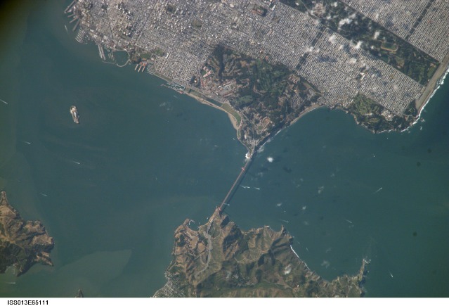
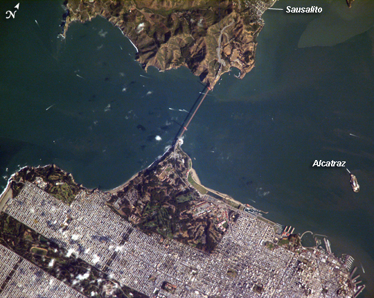
ISS013-E-65111 (6 Aug. 2006) --- Golden Gate, San Francisco, CA is featured in this image photographed by an Expedition 13 crewmember on the International Space Station. The Golden Gate of San Francisco Bay is one of the most recognizable straits in the world due to the Golden Gate Bridge that spans it. This image is a nearly cloud-free view of the northern San Francisco metropolitan area. The gridded pattern of streets, residential neighborhoods, and high-rise commercial blocks is clearly evident in the top half of the image. The twin support towers of the Golden Gate Bridge and its distinctive orange paint scheme can also be distinguished. The vegetated landscape of a portion of the Golden Gate National Recreation Area (green rectangular region at image center) connects the Bridge with steep, less vegetated hill slopes south of the city of Sausalito across the strait. Other features in this view include the former prison of Alcatraz, located on the island of the same name. Numerous boat wakes of commercial and pleasure craft are visible beneath and to the west of the Bridge. The shadow of the roadbed of the Bridge can be seen directly to the west of the Bridge itself. Regions of greenish-brown water visible in San Francisco Bay mark water masses with differing amounts of suspended sediment that are streamlined by the strong tidal currents that flow through the strait.Download Packaged File.
This option downloads the following items, packaged into a single file, if they are available:
- Browse image
- Cataloged information with captions
- Camera file
- Sound file
Server: 2 |
This service is provided by the International Space Station program. |
Recommended Citation: |
||

