| Home >> | Advanced Search >> |
 |
|
Astronaut Photography of Earth - Display Record
ISS004-E-6128
Low-resolution Browse Image
(Most browse images are not color adjusted.)Images
Conditions for Use of Images >>Image Transformation Tutorial >> Saving, Color Adjusting, and Printing Images >>
Images to View on Your Computer Now
| File Name | File Size (bytes) | Width | Height | Annotated | Cropped | Purpose | Comments | |
|---|---|---|---|---|---|---|---|---|
| View | ISS004-E-6128_2.JPG | 39223 | 400 | 272 | No | No | Photographic Highlights | From STIC, color adjusted |
| View | ISS004-E-6128.JPG | 58293 | 639 | 435 | No | No | From STIC, color adjusted | |
| View | ISS004-E-6128.JPG | 73879 | 540 | 540 | Yes | Yes | NASA's Earth Observatory web site | |
| View | ISS004-E-6128.JPG | 78088 | 540 | 540 | Photographic Highlights | actual files used | ||
| View | ISS004-E-6128_2.JPG | 160206 | 540 | 540 | Photographic Highlights | 540 px resized images | ||
| View | ISS004-E-6128.JPG | 1025194 | 3032 | 2064 | No | No | NASA's Earth Observatory web site |
Large Images to Request for Downloading
| File Name | File Size (bytes) | Width | Height | Annotated | Cropped | Purpose | Comments | |
|---|---|---|---|---|---|---|---|---|
| Request | ISS004-E-6128.JPG | 1025194 | 3032 | 2064 | No | No | From STIC, color adjusted | |
| Request | ISS004-E-6128.JPG | 1025194 | 3032 | 2064 | No | No | Earth From Space collection |
Download a Keyhole Markup Language (KML) file for use in Google Earth.
Electronic Image Data
Camera Files >> No sound file available.Identification
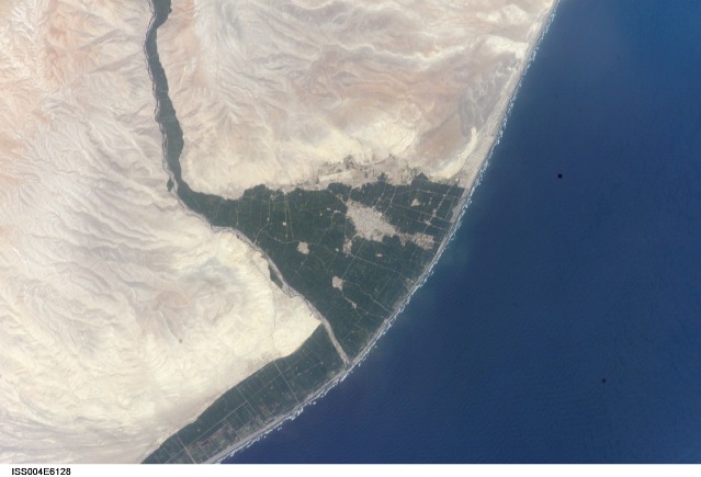
Mission: ISS004 Roll: E Frame: 6128 Mission ID on the Film or image: ISS004Country or Geographic Name: CHILE
Features: CAMANA, EL CONDO, AGR.
Center Point Latitude: -16.5 Center Point Longitude: -72.5 (Negative numbers indicate south for latitude and west for longitude)
Stereo: (Yes indicates there is an adjacent picture of the same area)
ONC Map ID: JNC Map ID:
Camera
Camera Tilt: 14Camera Focal Length: 400mm
Camera: E4: Kodak DCS760C Electronic Still Camera
Film: 3060E : 3060 x 2036 pixel CCD, RGBG array.
Quality
Film Exposure:Percentage of Cloud Cover: 10 (0-10)
Nadir
Date: 20020110 (YYYYMMDD)GMT Time: 184227 (HHMMSS)Nadir Point Latitude: -16.4, Longitude: -73.4 (Negative numbers indicate south for latitude and west for longitude)
Nadir to Photo Center Direction: East
Sun Azimuth: 253 (Clockwise angle in degrees from north to the sun measured at the nadir point)
Spacecraft Altitude: 216 nautical miles (400 km)
Sun Elevation Angle: 65 (Angle in degrees between the horizon and the sun, measured at the nadir point)
Orbit Number: 1950
Captions
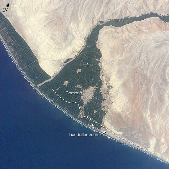
A tsunami washed over the low-lying coastal resort region near Camaná, southern Peru, following a strong earthquake on June 23, 2001. The earthquake was one of the most powerful of the last 35 years and had a magnitude of 8.4. After the initial quake, coastal residents witnessed a sudden drawdown of the ocean and knew a tsunami was imminent. They had less than 20 minutes to reach higher ground before the tsunami hit. Waves as high as 8 m came in four destructive surges reaching as far as 1.2 km inland. The dashed line marks the approximate area of tsunami inundation. Thousands of buildings were destroyed, and the combined earthquake and tsunami killed as many as 139 people.This image (ISS004-ESC-6128)was taken by astronauts onboard the International Space Station on 10 January 2002. It shows some of the reasons that the Camaná area was so vulnerable to tsunami damage. The area has a 1 km band of coastal plain that is less than 5 m in elevation. Much of the plain can be seen by the bright green fields of irrigated agriculture that contrast with the light-colored desert high ground. Many of the tsunami-related deaths were workers in the onion fields in the coastal plain that were unwilling to leave their jobs before the end of the shift. A number of lives were spared because the tsunami occurred during the resort off-season, during the daylight when people could see the ocean drawdown, and during one of the lowest tides of the year.
Download Packaged File.
This option downloads the following items, packaged into a single file, if they are available:
- Browse image
- Cataloged information with captions
- Camera file
- Sound file
Server: 2 |
This service is provided by the International Space Station program. |
Recommended Citation: |
||

