| Home >> | Advanced Search >> |
 |
|
Astronaut Photography of Earth - Display Record
ISS017-E-6110

Low-resolution Browse Image
(Most browse images are not color adjusted.)Images
Conditions for Use of Images >>Image Transformation Tutorial >> Saving, Color Adjusting, and Printing Images >>
Images to View on Your Computer Now
| File Name | File Size (bytes) | Width | Height | Annotated | Cropped | Purpose | Comments | |
|---|---|---|---|---|---|---|---|---|
| View | ISS017-E-6110.JPG | 79894 | 639 | 435 | No | No | ||
| View | ISS017-E-6110.JPG | 264888 | 540 | 357 | Yes | Yes | NASA's Earth Observatory web site |
Large Images to Request for Downloading
| File Name | File Size (bytes) | Width | Height | Annotated | Cropped | Purpose | Comments | |
|---|---|---|---|---|---|---|---|---|
| Request | ISS017-E-6110.JPG | 802142 | 1000 | 662 | No | Yes | NASA's Earth Observatory web site | |
| Request | ISS017-E-6110.JPG | 1156596 | 3032 | 2064 | No | No |
Download a Keyhole Markup Language (KML) file for use in Google Earth.
Electronic Image Data
Camera Files >> No sound file available.Identification
Mission: ISS017 Roll: E Frame: 6110 Mission ID on the Film or image: ISS017Country or Geographic Name: USA-ARIZONA
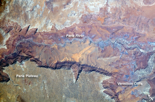
Features: PARIA RIVER, PARIA PLATEAU
Center Point Latitude: 36.9 Center Point Longitude: -111.6 (Negative numbers indicate south for latitude and west for longitude)
Stereo: (Yes indicates there is an adjacent picture of the same area)
ONC Map ID: JNC Map ID:
Camera
Camera Tilt: 20Camera Focal Length: 800mm
Camera: E4: Kodak DCS760C Electronic Still Camera
Film: 3060E : 3060 x 2036 pixel CCD, RGBG array.
Quality
Film Exposure:Percentage of Cloud Cover: 10 (0-10)
Nadir
Date: 20080502 (YYYYMMDD)GMT Time: 185738 (HHMMSS)Nadir Point Latitude: 36.4, Longitude: -110.6 (Negative numbers indicate south for latitude and west for longitude)
Nadir to Photo Center Direction: Northwest
Sun Azimuth: 165 (Clockwise angle in degrees from north to the sun measured at the nadir point)
Spacecraft Altitude: 180 nautical miles (333 km)
Sun Elevation Angle: 69 (Angle in degrees between the horizon and the sun, measured at the nadir point)
Orbit Number: 2136
Captions
Vermilion Cliffs and Paria River, ArizonaThe largest tributary of the Colorado River between Lake Powell and the Grand Canyon, the Paria River flows southeast from headwaters in southernmost Utah to join the Colorado River between Page, AZ and Marble Canyon. The Paria River provides spectacular scenery, and is known for the very narrow “slot” canyons that it cuts through the layered rocks of the Colorado Plateau. These canyons formed over millions of years by water erosion slicing deep into the rock layers. Exploring the river channel through the slot canyons is a popular activity for hikers and backpackers. Indeed, there is no road access to much of the river channel, and hiking in on foot is the only way to experience the slot canyons.
The Paria River also exposes the red and white layers of rocks beneath the Paria Plateau that are known as the Vermilion Cliffs (at image center). These rocks record the changing environmental conditions of the region during the early Mesozoic Era, ranging from widespread deserts to more water-rich periods when rivers flowed across the landscape. The spectacular scenery of the Vermilion Cliffs and Paria Canyon falls within the Vermilion Cliffs National Monument. This rugged and remote landscape is also home to many species of raptors – including the California condor - and other desert fauna like bighorn sheep.
Download Packaged File.
This option downloads the following items, packaged into a single file, if they are available:
- Browse image
- Cataloged information with captions
- Camera file
- Sound file
Server: 2 |
This service is provided by the International Space Station program. |
Recommended Citation: |
||

