| Home >> | Advanced Search >> |
 |
|
Astronaut Photography of Earth - Display Record
STS104-710-60

Low-resolution Browse Image
(Most browse images are not color adjusted.)Images
Conditions for Use of Images >>Image Transformation Tutorial >> Saving, Color Adjusting, and Printing Images >>
Images to View on Your Computer Now
| File Name | File Size (bytes) | Width | Height | Annotated | Cropped | Purpose | Comments | |
|---|---|---|---|---|---|---|---|---|
| View | STS104-710-60.JPG | 42391 | 515 | 512 | No | No | From ISD PhotoCDs | |
| View | STS104-710-60.JPG | 100321 | 540 | 540 | Yes | Yes | NASA's Earth Observatory web site | |
| View | STS104-710-60.JPG | 596427 | 1019 | 1021 | No | No | NASA's Earth Observatory web site | |
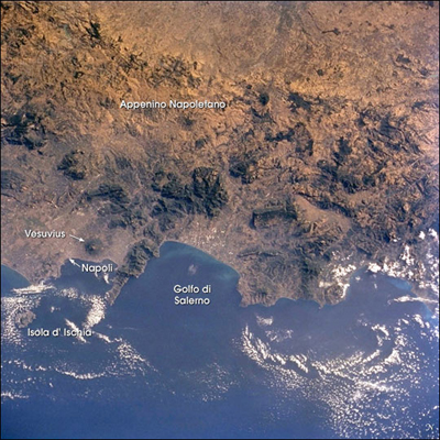
| View | STS104-710-60_2.JPG | 184020 | 400 | 400 | Yes | Yes | Photographic Highlights |
Large Images to Request for Downloading
| File Name | File Size (bytes) | Width | Height | Annotated | Cropped | Purpose | Comments | |
|---|---|---|---|---|---|---|---|---|
| Request | STS104-710-60.JPG | 148930 | 1031 | 1024 | No | No | From ISD PhotoCDs | |
| Request | STS104-710-60_2.JPG | 474587 | 2067 | 2048 | No | No | From ISD PhotoCDs | |
| Request | STS104-710-60_3.JPG | 1268162 | 4135 | 4096 | No | No | From ISD PhotoCDs | |
| Request | STS104-710-60.JPG | 596427 | 1019 | 1021 | No | Yes | Photographic Highlights | |
| Request | STS104-710-60.TIF | 4262186 | 1295 | 1257 | No | No |
Download a Keyhole Markup Language (KML) file for use in Google Earth.
Electronic Image Data
Camera files only apply to electronic still cameras.No sound file available.
Identification
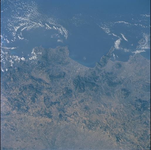
Mission: STS104 Roll: 710 Frame: 60 Mission ID on the Film or image: STS104Country or Geographic Name: ITALY
Features: MOUNT VESUVIUS, NAPLES
Center Point Latitude: 41.0 Center Point Longitude: 15.0 (Negative numbers indicate south for latitude and west for longitude)
Stereo: (Yes indicates there is an adjacent picture of the same area)
ONC Map ID: JNC Map ID:
Camera
Camera Tilt: 19Camera Focal Length: 250mm
Camera: HB: Hasselblad
Film: 5069 : Kodak Elite 100S, E6 Reversal, Replaces Lumiere, Warmer in tone vs. Lumiere.
Quality
Film Exposure:Percentage of Cloud Cover: 10 (0-10)
Nadir
Date: 20010723 (YYYYMMDD)GMT Time: 054256 (HHMMSS)Nadir Point Latitude: 42.0, Longitude: 14.3 (Negative numbers indicate south for latitude and west for longitude)
Nadir to Photo Center Direction: Southeast
Sun Azimuth: 80 (Clockwise angle in degrees from north to the sun measured at the nadir point)
Spacecraft Altitude: 210 nautical miles (389 km)
Sun Elevation Angle: 19 (Angle in degrees between the horizon and the sun, measured at the nadir point)
Orbit Number: 171
Captions
For more than 240 million years the region now known as Italy has been the scene of episodic volcanic activity. East-southeast of Napoli (Naples) stands the imposing cone of Vesuvius, which erupted explosively in 79 A.D. to bury Pompeii and Herculaneum. More recently, when the crew of Space Shuttle mission STS-104 captured this view, Mt. Etna (Sicily, not seen in this image, but photographed the day before) was spewing ash and gas thousands of meters into the air, some of which can be seen as a brownish smear over Isola d’ Ischia and the Tyrrhenian Sea.The Appenine ranges extend from northern Italy, down the boot of the peninsula and westward into Sicily. This photograph of the Appenino Napoletano is part of an 18-frame stereophoto mapping strip that spans the entire mountain chain. The almost 1200-km-long belt of volcanoes and folded/faulted mountains is a result of the ongoing collision of Africa and Eurasia, accompanied by the progressive closing of the Mediterranean Sea. Using overlapping pairs of stereophotos, and a special viewer, scientists can get a three-dimensional perspective on the ranges that surpasses any image viewed alone.
Download Packaged File.
This option downloads the following items, packaged into a single file, if they are available:
- Browse image
- Cataloged information with captions
- Camera file
- Sound file
Server: 2 |
This service is provided by the International Space Station program. |
Recommended Citation: |
||

