| Home >> | Advanced Search >> |
 |
|
Astronaut Photography of Earth - Display Record
STS031-73-59

Low-resolution Browse Image
(Most browse images are not color adjusted.)Images
Conditions for Use of Images >>Image Transformation Tutorial >> Saving, Color Adjusting, and Printing Images >>
Images to View on Your Computer Now
| File Name | File Size (bytes) | Width | Height | Annotated | Cropped | Purpose | Comments | |
|---|---|---|---|---|---|---|---|---|
| View | STS031-73-59.JPG | 23788 | 640 | 480 | No | No | ISD 1 | |
| View | STS031-73-59.JPG | 42739 | 540 | 546 | Yes | Yes | NASA's Earth Observatory web site | |
| View | STS031-73-59.TIF | 97071216 | 5699 | 5675 | No | No | NASA's Earth Observatory web site | |
| View | STS031-73-59_2.JPG | 20905 | 400 | 396 | No | No | Photographic Highlights | |
| View | STS031-73-59.JPG | 43995 | 540 | 535 | No | No | NASA's Earth Observatory web site | |
| View | STS031-73-59.BMP | 698936 | 512 | 455 | No | No |
Large Images to Request for Downloading
| File Name | File Size (bytes) | Width | Height | Annotated | Cropped | Purpose | Comments | |
|---|---|---|---|---|---|---|---|---|
| Request | STS031-73-59.JPG | 3464041 | 5699 | 5675 | No | NASA's Earth Observatory web site |
Download a Keyhole Markup Language (KML) file for use in Google Earth.
Electronic Image Data
Camera files only apply to electronic still cameras.No sound file available.
Identification
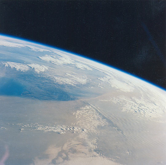
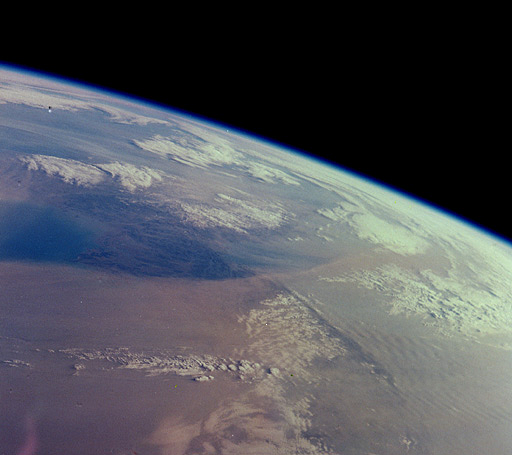
Mission: STS031 Roll: 73 Frame: 59 Mission ID on the Film or image: STS31Country or Geographic Name: NORTH KOREA
Features: PAN-DUST STORM, KOREA BAY
Center Point Latitude: 40.5 Center Point Longitude: 127.5 (Negative numbers indicate south for latitude and west for longitude)
Stereo: Yes (Yes indicates there is an adjacent picture of the same area)
ONC Map ID: JNC Map ID:
Camera
Camera Tilt: High ObliqueCamera Focal Length: 100mm
Camera: HB: Hasselblad
Film: 5017 : Kodak, natural color positive, Ektachrome, X Professional, ASA 64, standard base.
Quality
Film Exposure: NormalPercentage of Cloud Cover: 25 (11-25)
Nadir
Date: 19900425 (YYYYMMDD)GMT Time: 222953 (HHMMSS)Nadir Point Latitude: 28.5, Longitude: 123.5 (Negative numbers indicate south for latitude and west for longitude)
Nadir to Photo Center Direction: North
Sun Azimuth: 83 (Clockwise angle in degrees from north to the sun measured at the nadir point)
Spacecraft Altitude: 334 nautical miles (619 km)
Sun Elevation Angle: 16 (Angle in degrees between the horizon and the sun, measured at the nadir point)
Orbit Number: 22
Captions
Dust blowing off the Gobi desert eastward across the China toward the Pacific Ocean is a common event in April. Space Shuttle astronauts have photographed these dusts storms several times. The photographs above, taken by astronauts on April 25, 1990, show a thick blanket of dust that entirely obscures the southern half of the Korean Peninsula. The dust is being transported from west (left) to east (right). The mountainous spine of the peninsula induces gravity waves in the dust cloud on the downwind (east) side.The mosaic (NASA photos STS31-73-54 (left) and STS31-73-59 (right)) shows a second dust front over the Beijing region (Beijing lies under the northern margin), situated to the north of the main dust. An interpretive map is also provided.
The source of the dust is the vast loess (wind-laid dust) sheet of Inner Mongolia that stretches west from Beijing 1400 km to the Sinkiang border. The climatic gradient is characterized by rapidly decreasing rainfall west from Beijing, from 500 mm/yr to 250 mm/yr only 300 km upwind. Below 250 mm of yearly rainfall, vegetation density is low enough to allow wind deflation of surface dust. Air masses over the Takla Makan Desert of Sinkiang are usually dust laden to some degree. Occasionally, the dust loading becomes heavy and moves as far as Korea (as shown here), and then offshore over the Pacific.
Link to Earth Observatory Caption >>
Download Packaged File.
This option downloads the following items, packaged into a single file, if they are available:
- Browse image
- Cataloged information with captions
- Camera file
- Sound file
Server: 2 |
This service is provided by the International Space Station program. |
Recommended Citation: |
||

