| Home >> | Advanced Search >> |
 |
|
Astronaut Photography of Earth - Display Record
ISS017-E-5763

Low-resolution Browse Image
(Most browse images are not color adjusted.)Images
Conditions for Use of Images >>Image Transformation Tutorial >> Saving, Color Adjusting, and Printing Images >>
Images to View on Your Computer Now
| File Name | File Size (bytes) | Width | Height | Annotated | Cropped | Purpose | Comments | |
|---|---|---|---|---|---|---|---|---|
| View | ISS017-E-5763.JPG | 59492 | 639 | 435 | No | No | ||
| View | ISS017-E-5763.JPG | 231095 | 540 | 373 | Yes | Yes | NASA's Earth Observatory web site |
Large Images to Request for Downloading
| File Name | File Size (bytes) | Width | Height | Annotated | Cropped | Purpose | Comments | |
|---|---|---|---|---|---|---|---|---|
| Request | ISS017-E-5763.JPG | 669014 | 1000 | 691 | No | Yes | NASA's Earth Observatory web site | |
| Request | ISS017-E-5763.JPG | 1086196 | 3032 | 2064 | No | No |
Download a Keyhole Markup Language (KML) file for use in Google Earth.
Electronic Image Data
Camera Files >> No sound file available.Identification
Mission: ISS017 Roll: E Frame: 5763 Mission ID on the Film or image: ISS017Country or Geographic Name: USA-LOUISIANA
Features: L. PONCHARTRAIN, SED. PLUME
Center Point Latitude: 30.0 Center Point Longitude: -90.0 (Negative numbers indicate south for latitude and west for longitude)
Stereo: (Yes indicates there is an adjacent picture of the same area)
ONC Map ID: JNC Map ID:
Camera
Camera Tilt: 38Camera Focal Length: 180mm
Camera: E4: Kodak DCS760C Electronic Still Camera
Film: 3060E : 3060 x 2036 pixel CCD, RGBG array.
Quality
Film Exposure:Percentage of Cloud Cover: 10 (0-10)
Nadir
Date: 20080429 (YYYYMMDD)GMT Time: 192803 (HHMMSS)Nadir Point Latitude: 30.7, Longitude: -92.2 (Negative numbers indicate south for latitude and west for longitude)
Nadir to Photo Center Direction: East
Sun Azimuth: 235 (Clockwise angle in degrees from north to the sun measured at the nadir point)
Spacecraft Altitude: 180 nautical miles (333 km)
Sun Elevation Angle: 66 (Angle in degrees between the horizon and the sun, measured at the nadir point)
Orbit Number: 2089
Captions
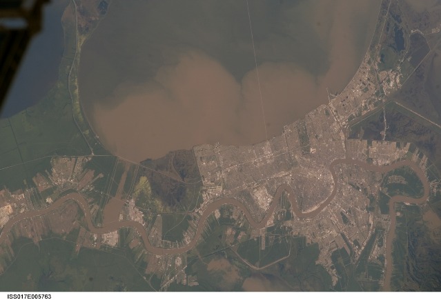
Lake Pontchartrain and the Bonnet Carre Spillway, Louisiana, USALake Pontchartrain, a big body of water immediately north of New Orleans, occupies the upper part of this astronaut photograph, with the winding course of the muddy Mississippi River snaking across the bottom of the view (flow is east, from left to right). The city of New Orleans is sandwiched between the lake and river.
Heavy rain in March and April 2008 in the Mississippi’s catchment area raised water levels in the river sufficiently to make the Army Corps of Engineers take action. To reduce the volume of the river where it passes through New Orleans, the Corps opened the Bonnet Carre Spillway (lower left), a major engineering structure 18 km upriver from New Orleans. The spillway, a 1.6 km-wide gap in the developments along the Mississippi levees, is an integral part of the river and canal system that allows Mississippi river water to flow into Lake Pontchartrain. The spillway control structure itself is visible as a thin, discontinuous, white line along the river’s edge in this image.
The spillway has only been opened eight times since 1937. News of the opening in April 2008 was transmitted to astronauts aboard the International Space Station who managed to capture the immediate effect of muddy water flowing down the spillway and into Lake Pontchartrain, where it forms great brown lobes in the otherwise green water. These lobes moved slowly east along the New Orleans shoreline, where the line of the Lake Pontchartrain Causeway, the longest bridge in the U.S., can be seen, top right.
Opening the spillway protects New Orleans in various ways. First, it reduces pressure on the levees, which famously collapsed at some points during the onslaught of Hurricane Katrina in 2005. Keeping water levels below critical high levels also helps the river channel to accommodate the discharge of water, and reduces both the speed of flow and cross currents in the river which can interfere with vessels navigating the river – or even cause collisions with levees.
Download Packaged File.
This option downloads the following items, packaged into a single file, if they are available:
- Browse image
- Cataloged information with captions
- Camera file
- Sound file
Server: 2 |
This service is provided by the International Space Station program. |
Recommended Citation: |
||

