| Home >> | Advanced Search >> |
 |
|
Astronaut Photography of Earth - Display Record
ISS001-E-5316

Low-resolution Browse Image
(Most browse images are not color adjusted.)Images
Conditions for Use of Images >>Image Transformation Tutorial >> Saving, Color Adjusting, and Printing Images >>
Images to View on Your Computer Now
| File Name | File Size (bytes) | Width | Height | Annotated | Cropped | Purpose | Comments | |
|---|---|---|---|---|---|---|---|---|
| View | ISS001-E-5316_2.JPG | 4830 | 225 | 149 | No | No | ||
| View | ISS001-E-5316.JPG | 54366 | 540 | 405 | Yes | Yes | NASA's Earth Observatory web site | |
| View | ISS001-E-5316.JPG | 83239 | 640 | 425 | No | No | ||
| View | ISS001-E-5316_3.JPG | 225375 | 961 | 639 | No | No |
Large Images to Request for Downloading
| File Name | File Size (bytes) | Width | Height | Annotated | Cropped | Purpose | Comments | |
|---|---|---|---|---|---|---|---|---|
| Request | ISS001-E-5316.JPG | 445891 | 1530 | 1018 | No | No | From STIC |
Download a Keyhole Markup Language (KML) file for use in Google Earth.
Electronic Image Data
No camera file data available >> No sound file available.Identification
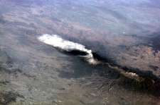
Mission: ISS001 Roll: E Frame: 5316 Mission ID on the Film or image: ISS01Country or Geographic Name: MEXICO
Features: POPOCATEPETL VOL., PLUME
Center Point Latitude: 19.0 Center Point Longitude: -98.5 (Negative numbers indicate south for latitude and west for longitude)
Stereo: (Yes indicates there is an adjacent picture of the same area)
ONC Map ID: JNC Map ID:
Camera
Camera Tilt:Camera Focal Length: mm
Camera: E2: Kodak DCS460 Electronic Still Camera
Film: 3060E : 3060 x 2036 pixel CCD, RGBG array.
Quality
Film Exposure:Percentage of Cloud Cover: 10 (0-10)
Nadir
Date: 20010123 (YYYYMMDD)GMT Time: (HHMMSS)Nadir Point Latitude: , Longitude: (Negative numbers indicate south for latitude and west for longitude)
Nadir to Photo Center Direction:
Sun Azimuth: (Clockwise angle in degrees from north to the sun measured at the nadir point)
Spacecraft Altitude: nautical miles (0 km)
Sun Elevation Angle: (Angle in degrees between the horizon and the sun, measured at the nadir point)
Orbit Number:
Captions
Popocatépetl, or Popo, the active volcano located about 70 km southeast of Mexico City, sends a plume south on January 23, 2001. The astronaut crew on the International Space Station Alpha observed and recorded this image as they orbited to the northeast of the volcano. Popo has been frequently active for six years. On this day, the eruption plume reportedly rose to more than 9 km above sea level [for reference, Popo’s summit elevation is 5426 m (17,800 feet)]. Note the smaller ash plume below the main plume (arrow). The perspective from the ISS allowed the astronauts this unique 3 dimensional view.Popo is situated between two large population centers: Mexico City (more than 18 million people, and just off the image to the right) and Puebla (about 1.2 million people). The region’s dense population provides the potential for extreme impacts from volcanic hazards. Recent eruptions have been frequent, and have resulted in evacuations around the mountain.
Download Packaged File.
This option downloads the following items, packaged into a single file, if they are available:
- Browse image
- Cataloged information with captions
- Camera file
- Sound file
Server: 2 |
This service is provided by the International Space Station program. |
Recommended Citation: |
||

