| Home >> | Advanced Search >> |
 |
|
Astronaut Photography of Earth - Display Record
ISS004-E-5201
Low-resolution Browse Image
(Most browse images are not color adjusted.)Images
Conditions for Use of Images >>Image Transformation Tutorial >> Saving, Color Adjusting, and Printing Images >>
Images to View on Your Computer Now
| File Name | File Size (bytes) | Width | Height | Annotated | Cropped | Purpose | Comments | |
|---|---|---|---|---|---|---|---|---|
| View | ISS004-E-5201.JPG | 78519 | 540 | 467 | Yes | Yes | NASA's Earth Observatory web site | |
| View | ISS004-E-5201.JPG | 114252 | 639 | 447 | No | No | ||
| View | ISS004-E-5201.JPG | 320852 | 540 | 405 | Photographic Highlights | 540 px resized images | ||
| View | ISS004-E-5201.JPG | 993938 | 1000 | 682 | No | No | NASA's Earth Observatory web site |
Large Images to Request for Downloading
| File Name | File Size (bytes) | Width | Height | Annotated | Cropped | Purpose | Comments | |
|---|---|---|---|---|---|---|---|---|
| Request | ISS004-E-5201.JPG | 982323 | 1024 | 768 | Photographic Highlights | actual files used | ||
| Request | ISS004-E-5201.JPG | 1413447 | 3032 | 2120 | No | No |
Download a Keyhole Markup Language (KML) file for use in Google Earth.
Electronic Image Data
No camera file data available >> No sound file available.Identification
Mission: ISS004 Roll: E Frame: 5201 Mission ID on the Film or image: ISS004Country or Geographic Name: USA-ARIZONA
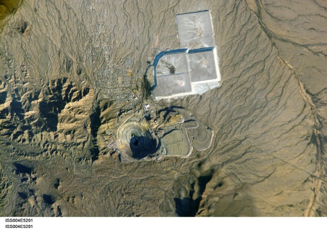
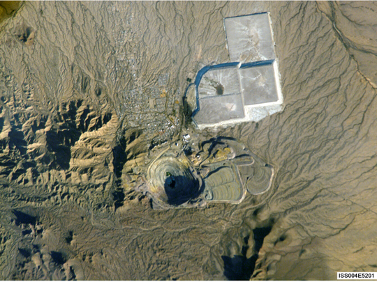
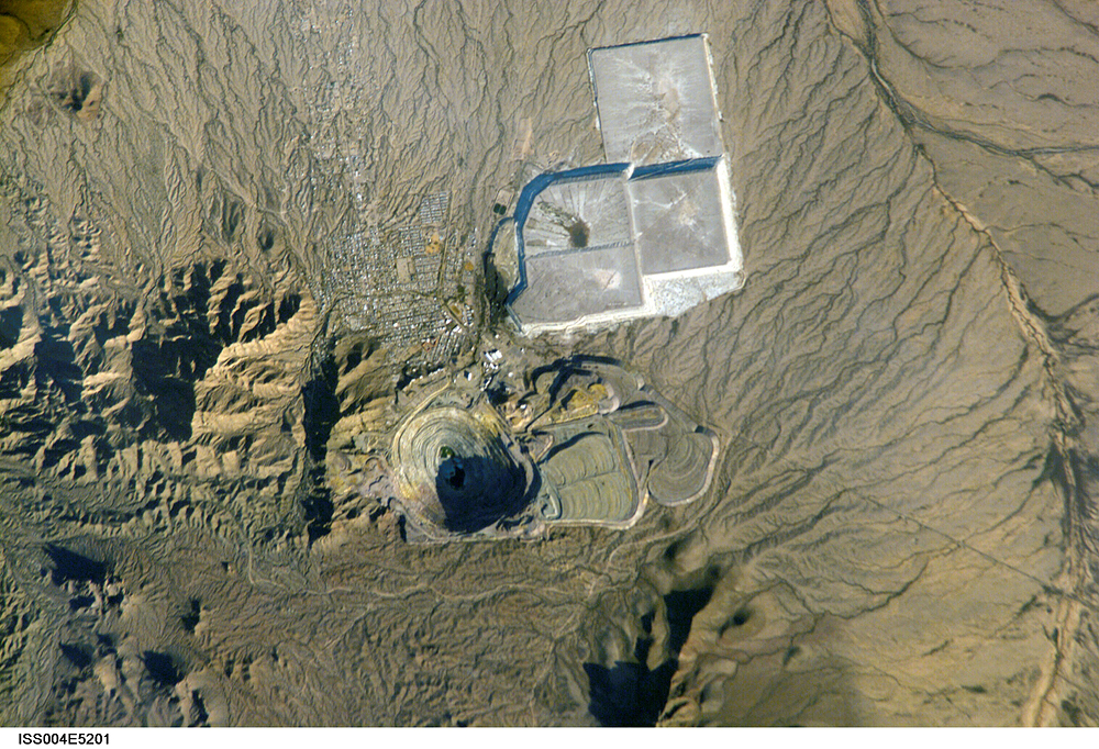
Features: NEW CORNELIA MINE
Center Point Latitude: 32.5 Center Point Longitude: -113.0 (Negative numbers indicate south for latitude and west for longitude)
Stereo: (Yes indicates there is an adjacent picture of the same area)
ONC Map ID: JNC Map ID:
Camera
Camera Tilt:Camera Focal Length: mm
Camera:
Film: 3060E : 3060 x 2036 pixel CCD, RGBG array.
Quality
Film Exposure:Percentage of Cloud Cover: 10 (0-10)
Nadir
Date: 2002____ (YYYYMMDD)GMT Time: (HHMMSS)Nadir Point Latitude: , Longitude: (Negative numbers indicate south for latitude and west for longitude)
Nadir to Photo Center Direction:
Sun Azimuth: (Clockwise angle in degrees from north to the sun measured at the nadir point)
Spacecraft Altitude: nautical miles (0 km)
Sun Elevation Angle: (Angle in degrees between the horizon and the sun, measured at the nadir point)
Orbit Number:
Captions
Although this photograph may appear to be a small pit mine as photographed from the air, it is actually a pit mine that is about a mile wide and just over a thousand feet deep and was photographed by astronauts orbiting the Earth on board the International Space Station. The New Cornelia Mine is located just south of Ajo, Arizona. Small-scale mining of copper in this area began with the Spaniards and Mexicans as early as 1750. This large-scale, systematic operation began in 1912 and expanded rapidly for the next 50 years. Since the mid 1980s, activity has been limited because of low prices for copper on the world market. Note the tailings deposits to the east (right) and the larger containment ponds for extraction processes to the northeast.Download Packaged File.
This option downloads the following items, packaged into a single file, if they are available:
- Browse image
- Cataloged information with captions
- Camera file
- Sound file
Server: 2 |
This service is provided by the International Space Station program. |
Recommended Citation: |
||

