| Home >> | Advanced Search >> |
 |
|
Astronaut Photography of Earth - Display Record
ISS016-E-5121

Low-resolution Browse Image
(Most browse images are not color adjusted.)Images
Conditions for Use of Images >>Image Transformation Tutorial >> Saving, Color Adjusting, and Printing Images >>
Images to View on Your Computer Now
| File Name | File Size (bytes) | Width | Height | Annotated | Cropped | Purpose | Comments | |
|---|---|---|---|---|---|---|---|---|
| View | ISS016-E-5121.JPG | 69476 | 639 | 435 | No | No | ||
| View | ISS016-E-5121.JPG | 289878 | 540 | 325 | Yes | Yes | NASA's Earth Observatory web site |
Large Images to Request for Downloading
| File Name | File Size (bytes) | Width | Height | Annotated | Cropped | Purpose | Comments | |
|---|---|---|---|---|---|---|---|---|
| Request | ISS016-E-5121.JPG | 881986 | 1000 | 601 | No | Yes | NASA's Earth Observatory web site | |
| Request | ISS016-E-5121.JPG | 1238595 | 3032 | 2064 | No | No |
Download a Keyhole Markup Language (KML) file for use in Google Earth.
Electronic Image Data
Camera Files >> No sound file available.Identification
Mission: ISS016 Roll: E Frame: 5121 Mission ID on the Film or image: ISS016Country or Geographic Name: NEW ZEALAND-NI
Features: WELLINGTON METRO AREA
Center Point Latitude: -41.3 Center Point Longitude: 174.8 (Negative numbers indicate south for latitude and west for longitude)
Stereo: (Yes indicates there is an adjacent picture of the same area)
ONC Map ID: JNC Map ID:
Camera
Camera Tilt: 48Camera Focal Length: 800mm
Camera: E4: Kodak DCS760C Electronic Still Camera
Film: 3060E : 3060 x 2036 pixel CCD, RGBG array.
Quality
Film Exposure:Percentage of Cloud Cover: 10 (0-10)
Nadir
Date: 20071021 (YYYYMMDD)GMT Time: 185404 (HHMMSS)Nadir Point Latitude: -39.3, Longitude: 177.6 (Negative numbers indicate south for latitude and west for longitude)
Nadir to Photo Center Direction: Southwest
Sun Azimuth: 89 (Clockwise angle in degrees from north to the sun measured at the nadir point)
Spacecraft Altitude: 188 nautical miles (348 km)
Sun Elevation Angle: 18 (Angle in degrees between the horizon and the sun, measured at the nadir point)
Orbit Number: 3074
Captions
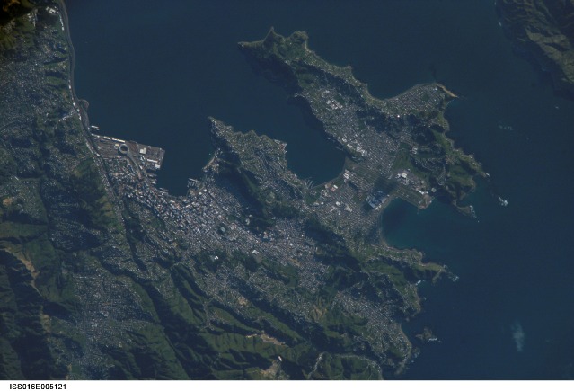
ISS016-E-005121 (21 Oct. 2007) --- Wellington, New Zealand is featured in this image photographed by an Expedition 16 crewmember on the International Space Station. New Zealand's capital of Wellington is located at the southwestern tip of North Island near the Cook Strait. The city is the second largest in New Zealand (after Auckland), and at 41 degrees south latitude, it is the southernmost capital city of the world. The North and South Islands of New Zealand are located along the active Australian-Pacific tectonic plate boundary -- the Islands are only a small part of a larger submerged fragment of continental crust. The glancing collision of these two tectonic plates results in uplift of the land surface, expressed as low hills on North Island and the Southern Alps on South Island. Local topography visible in this view is a result of these tectonic forces and weathering processes, which have exerted a strong influence on the morphology of the city. Tightly clustered white rooftops and high building density of the central business district are visible to the south of the Westpac Stadium between vegetated (green) northeast-southwest trending ridges. Lower density development (gray gridded regions with scattered white rooftops) has spread eastwards along the Miramar Peninsula. Five major faults that run through the Wellington metropolitan area; the largest magnitude earthquake recorded in New Zealand (approximately 8.2 on the Richter Scale) occurred in 1855 on one of these (the Wairarapa Fault). Recognition of the potential seismic hazard in the metropolitan area has led to adoption of building codes to maximize structural resistance to earthquake damage.Wellington, New Zealand:
New Zealand’s capital, Wellington, sits at the southwestern tip of North Island near the Cook Strait. The city in the second largest in New Zealand (after Auckland), and at 41 south latitude, it is the southernmost capital city in the world. The North and South Islands of New Zealand are located along the active Australian-Pacific tectonic plate boundary. The glancing collision of these two tectonic plates results in uplift of the land surface, expressed as low hills on North Island and the Southern Alps on South Island.
Local topography visible in this astronaut photograph is a result of these tectonic forces and weathering, and the topography has exerted a strong influence on the shape of the city. The tightly clustered white rooftops of the central business district are visible to the south of the Westpac Stadium between vegetated (green) northeast-southwest trending ridges. Lower density development (gray gridded areas with scattered white rooftops) has spread eastwards along the Miramar Peninsula.
Five major faults run through the Wellington metropolitan area; the largest magnitude earthquake recorded in New Zealand (about 8.2 magnitude) occurred in 1855 on one of these faults. Recognizing the potential seismic hazard, the city has adopted building codes that maximize structural resistance to earthquake damage.
Download Packaged File.
This option downloads the following items, packaged into a single file, if they are available:
- Browse image
- Cataloged information with captions
- Camera file
- Sound file
Server: 2 |
This service is provided by the International Space Station program. |
Recommended Citation: |
||

