| Home >> | Advanced Search >> |
 |
|
Astronaut Photography of Earth - Display Record
ISS003-E-5120

Low-resolution Browse Image
(Most browse images are not color adjusted.)Images
Conditions for Use of Images >>Image Transformation Tutorial >> Saving, Color Adjusting, and Printing Images >>
Images to View on Your Computer Now
| File Name | File Size (bytes) | Width | Height | Annotated | Cropped | Purpose | Comments | |
|---|---|---|---|---|---|---|---|---|
| View | ISS003-E-5120_2.JPG | 23077 | 400 | 265 | No | No | Photographic Highlights | |
| View | ISS003-E-5120.JPG | 38847 | 530 | 358 | Yes | Yes | NASA's Earth Observatory web site | |
| View | ISS003-E-5120.JPG | 75898 | 640 | 437 | No | No | ||
| View | ISS003-E-5120.JPG | 270391 | 540 | 359 | Photographic Highlights | (540px resized images) | ||
| View | ISS003-E-5120.JPG | 1831151 | 3060 | 2092 | No | No | NASA's Earth Observatory web site |
Large Images to Request for Downloading
| File Name | File Size (bytes) | Width | Height | Annotated | Cropped | Purpose | Comments | |
|---|---|---|---|---|---|---|---|---|
| Request | ISS003-E-5120.JPG | 389406 | 1024 | 681 | Photographic Highlights | actual files used | ||
| Request | ISS003-E-5120.JPG | 1831151 | 3060 | 2092 | No | No | Earth From Space collection | |
| Request | ISS003-E-5120.JPG | 1831151 | 3060 | 2092 | No | No | ||
| Request | ISS003-E-5120.TIF | 18695900 | 3060 | 2036 | No | No |
Download a Keyhole Markup Language (KML) file for use in Google Earth.
Electronic Image Data
Camera Files >> No sound file available.Identification
Mission: ISS003 Roll: E Frame: 5120 Mission ID on the Film or image: ISS003Country or Geographic Name: EGYPT
Features: GIZA, PYRAMIDS
Center Point Latitude: 30.0 Center Point Longitude: 31.0 (Negative numbers indicate south for latitude and west for longitude)
Stereo: (Yes indicates there is an adjacent picture of the same area)
ONC Map ID: JNC Map ID:
Camera
Camera Tilt:Camera Focal Length: 800mm
Camera: E2: Kodak DCS460 Electronic Still Camera
Film: 3060E : 3060 x 2036 pixel CCD, RGBG array.
Quality
Film Exposure:Percentage of Cloud Cover: 10 (0-10)
Nadir
Date: 20010815 (YYYYMMDD)GMT Time: 12____ (HHMMSS)Nadir Point Latitude: , Longitude: (Negative numbers indicate south for latitude and west for longitude)
Nadir to Photo Center Direction:
Sun Azimuth: 248 (Clockwise angle in degrees from north to the sun measured at the nadir point)
Spacecraft Altitude: 205 nautical miles (380 km)
Sun Elevation Angle: 57 (Angle in degrees between the horizon and the sun, measured at the nadir point)
Orbit Number: 3636
Captions
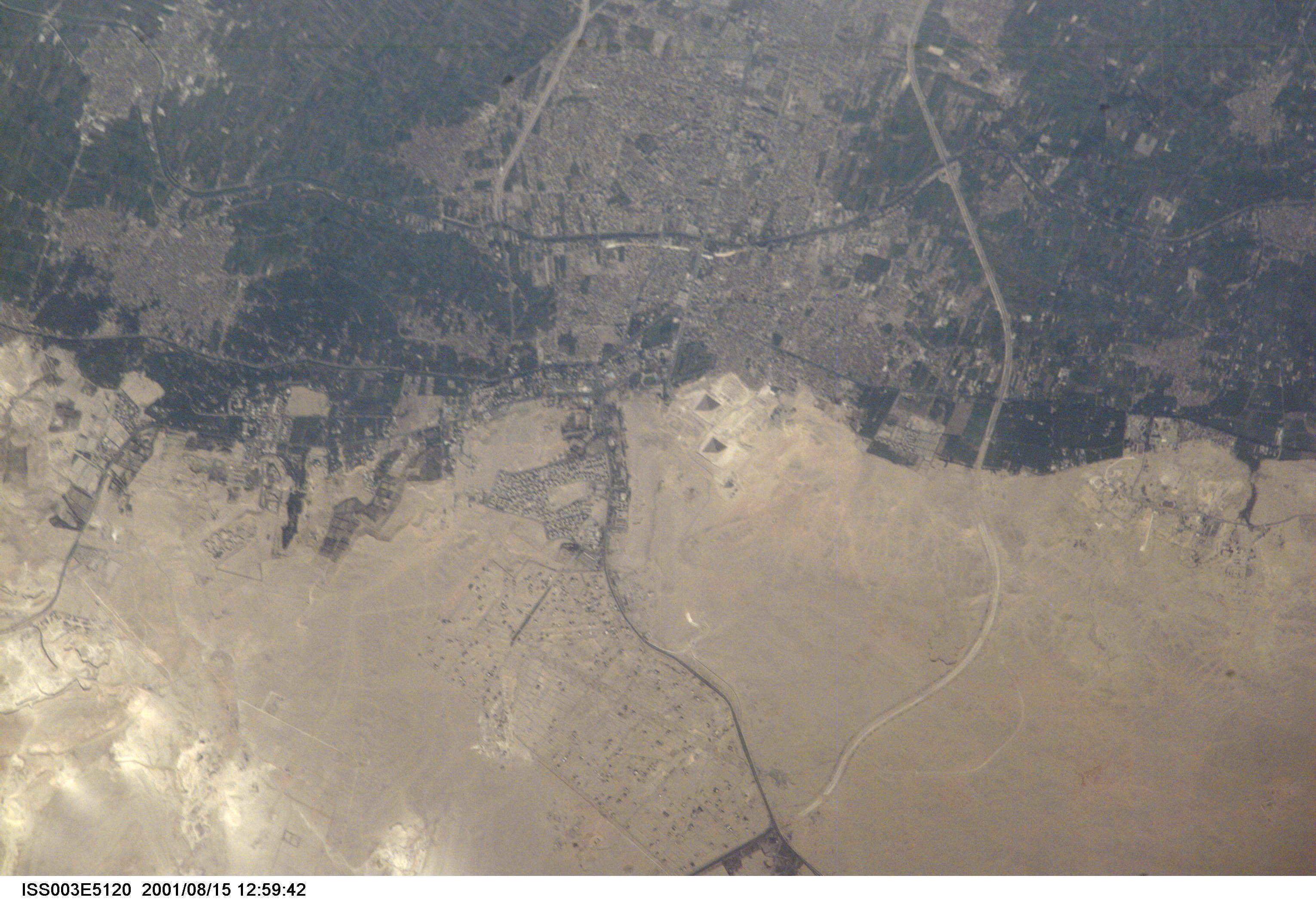
Space Station view of the Pyramids at GizaOne of the world’s most famous archaeological sites has been photographed in amazing detail by the astronauts onboard Space Station Alpha. This image, taken 15 August, 2001, represents the greatest detail of the Giza plateau captured from a human-occupied spacecraft (approximate 7 m resolution). Afternoon sun casts shadows that help the eye make out the large pyramids of Khufu, Khafre and Menkaure. Sets of three smaller queens’ pyramids can be seen to the east of the Pyramid of Khufu and south of the Pyramid of Menkaure. The light-colored causeway stretching from the Mortuary Temple at the Pyramid of Khafre to the Valley Temple near the Sphinx (arrow) can also be seen. Because it is not tall enough to cast a deep shadow, the Sphinx itself cannot readily be distinguished.
Although some commercial satellites, such as IKONOS, have imaged the Pyramids at Giza in greater detail (1 m resolution), this image highlights the potential of the International Space Station as a remote sensing platform. A commercial digital camera without space modifications was used to obtain this picture. Similarly, a variety of remote sensing instruments developed for use on aircraft can potentially be used from the Space Station.
Download Packaged File.
This option downloads the following items, packaged into a single file, if they are available:
- Browse image
- Cataloged information with captions
- Camera file
- Sound file
Server: 2 |
This service is provided by the International Space Station program. |
Recommended Citation: |
||

