| Home >> | Advanced Search >> |
 |
|
Astronaut Photography of Earth - Display Record
STS100-703-46

Low-resolution Browse Image
(Most browse images are not color adjusted.)Images
Conditions for Use of Images >>Image Transformation Tutorial >> Saving, Color Adjusting, and Printing Images >>
Images to View on Your Computer Now
| File Name | File Size (bytes) | Width | Height | Annotated | Cropped | Purpose | Comments | |
|---|---|---|---|---|---|---|---|---|
| View | STS100-703-46.JPG | 21655 | 515 | 512 | No | No | From ISD PhotoCDs | |
| View | STS100-703-46.JPG | 189148 | 540 | 579 | Yes | Yes | NASA's Earth Observatory web site | |
| View | STS100-703-46_2.JPG | 147300 | 400 | 313 | Yes | Yes | Photographic Highlights | |
| View | STS100-703-46.JPG | 286552 | 540 | 423 | Yes | Yes | NASA's Earth Observatory web site |
Large Images to Request for Downloading
| File Name | File Size (bytes) | Width | Height | Annotated | Cropped | Purpose | Comments | |
|---|---|---|---|---|---|---|---|---|
| Request | STS100-703-46.JPG | 70210 | 1031 | 1024 | No | No | From ISD PhotoCDs | |
| Request | STS100-703-46_2.JPG | 220951 | 2063 | 2048 | No | No | From ISD PhotoCDs | |
| Request | STS100-703-46_3.JPG | 682257 | 4127 | 4096 | No | No | From ISD PhotoCDs | |
| Request | STS100-703-46_2.TIF | 2985466 | 1268 | 1265 | No | No | ||
| Request | STS100-703-46.TIF | 11829606 | 2536 | 2531 | No | No |
Download a Keyhole Markup Language (KML) file for use in Google Earth.
Electronic Image Data
Camera files only apply to electronic still cameras.No sound file available.
Identification
Mission: STS100 Roll: 703 Frame: 46 Mission ID on the Film or image: STS100Country or Geographic Name: EGYPT
Features: SUEZ CANAL, PORT SAID
Center Point Latitude: 31.0 Center Point Longitude: 32.0 (Negative numbers indicate south for latitude and west for longitude)
Stereo: (Yes indicates there is an adjacent picture of the same area)
ONC Map ID: JNC Map ID:
Camera
Camera Tilt: 27Camera Focal Length: 250mm
Camera: HB: Hasselblad
Film: 5069 : Kodak Elite 100S, E6 Reversal, Replaces Lumiere, Warmer in tone vs. Lumiere.
Quality
Film Exposure:Percentage of Cloud Cover: 10 (0-10)
Nadir
Date: 20010420 (YYYYMMDD)GMT Time: 111647 (HHMMSS)Nadir Point Latitude: 31.9, Longitude: 31.3 (Negative numbers indicate south for latitude and west for longitude)
Nadir to Photo Center Direction: Southeast
Sun Azimuth: 228 (Clockwise angle in degrees from north to the sun measured at the nadir point)
Spacecraft Altitude: 136 nautical miles (252 km)
Sun Elevation Angle: 62 (Angle in degrees between the horizon and the sun, measured at the nadir point)
Orbit Number: 12
Captions
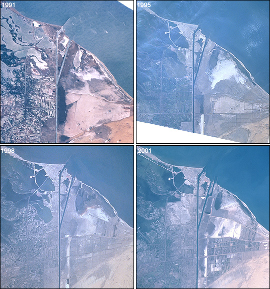
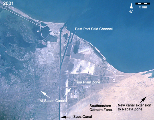
This time series of photographs of the Mediterranean coast near the Suez Canal (Images STS040-77-91, STS073-708-83, STS090-728-55, and STS100-703-46) shows ten years of changes associated with two of Egypt’s "Mega" Development Projects. At the mouth of the canal, a large auxiliary channel has been formed as part of a new central hub port and industrial zone, known as the East Port-Said Project. Further south, the effects of the Al-Salam (El Salam or "Peace") Canal and North Sinai Agricultural Development Program can be seen as desert is converted to irrigated agriculture.The Al-Salam Canal brings water from the Damietta Branch of the Nile, under the Suez Canal to the Sinai Peninsula. First, the project provided irrigation waters to the area west of the Suez Canal. In October 1997, the culvert under the Suez was completed and water became available for irrigation in Block 1, the Tina Plain Zone (50,000 acres). Fields soon began to appear.
The most recent photo, taken by the STS-100 crew in April 2001, shows a new extension of canals into the desert to the east. (Click to see a larger, labeled photo.) These canals will eventually feed irrigation in Block 3, the Raba’a Zone. Development of more fields can also be seen south of the Tina Plain Zone in an area called Block 2, the Southeastern Qantara Zone. Plans call for extending the canal by mid-2002 and irrigating a total of 620,000 acres. The cost of the project is estimated to exceed 7.5 billion Egyptian pounds (about $2 billion). Given the scarcity of water resources in the region and the costs involved, it is not surprising that the project is controversial within and outside Egypt.
Link to Earth Observatory Caption >>
Download Packaged File.
This option downloads the following items, packaged into a single file, if they are available:
- Browse image
- Cataloged information with captions
- Camera file
- Sound file
Server: 2 |
This service is provided by the International Space Station program. |
Recommended Citation: |
||

