| Home >> | Advanced Search >> |
 |
|
Astronaut Photography of Earth - Display Record
ISS006-E-44645

Low-resolution Browse Image
(Most browse images are not color adjusted.)Images
Conditions for Use of Images >>Image Transformation Tutorial >> Saving, Color Adjusting, and Printing Images >>
Images to View on Your Computer Now
| File Name | File Size (bytes) | Width | Height | Annotated | Cropped | Purpose | Comments | |
|---|---|---|---|---|---|---|---|---|
| View | ISS006-E-44645.JPG | 39449 | 540 | 405 | Photographic Highlights | (540 px resized images) | ||
| View | ISS006-E-44645.JPG | 52381 | 540 | 405 | Yes | Yes | NASA's Earth Observatory web site | |
| View | ISS006-E-44645.JPG | 52381 | 540 | 405 | Yes | Yes | NASA's Earth Observatory web site | |
| View | ISS006-E-44645.JPG | 62731 | 639 | 435 | No | No | ||
| View | ISS006-E-44645.JPG | 117473 | 1200 | 816 | No | No | Cities collection | |
| View | ISS006-E-44645.JPG | 1972520 | 3032 | 2064 | No | No | Cities collection |
Large Images to Request for Downloading
| File Name | File Size (bytes) | Width | Height | Annotated | Cropped | Purpose | Comments | |
|---|---|---|---|---|---|---|---|---|
| Request | ISS006-E-44645.JPG | 217411 | 1024 | 768 | Photographic Highlights | (actual files used) | ||
| Request | ISS006-E-44645.JPG | 1972520 | 3032 | 2064 | No | No |
Download a Keyhole Markup Language (KML) file for use in Google Earth.
Electronic Image Data
Camera Files >> No sound file available.Identification
Mission: ISS006 Roll: E Frame: 44645 Mission ID on the Film or image: ISS006Country or Geographic Name: EGYPT
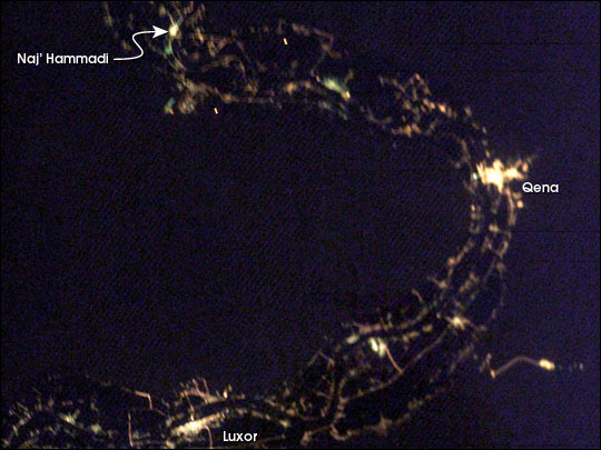
Features: VALLEY OF THE KINGS AT NIGHT
Center Point Latitude: 26.0 Center Point Longitude: 32.5 (Negative numbers indicate south for latitude and west for longitude)
Stereo: (Yes indicates there is an adjacent picture of the same area)
ONC Map ID: JNC Map ID:
Camera
Camera Tilt: 28Camera Focal Length: 85mm
Camera: E4: Kodak DCS760C Electronic Still Camera
Film: 3060E : 3060 x 2036 pixel CCD, RGBG array.
Quality
Film Exposure:Percentage of Cloud Cover: 10 (0-10)
Nadir
Date: 20030411 (YYYYMMDD)GMT Time: 183326 (HHMMSS)Nadir Point Latitude: 25.2, Longitude: 34.2 (Negative numbers indicate south for latitude and west for longitude)
Nadir to Photo Center Direction: West
Sun Azimuth: 299 (Clockwise angle in degrees from north to the sun measured at the nadir point)
Spacecraft Altitude: 212 nautical miles (393 km)
Sun Elevation Angle: -33 (Angle in degrees between the horizon and the sun, measured at the nadir point)
Orbit Number: 1064
Captions
City lights define the Nile River Valley as it snakes across the Egyptian desert. The cities of Naj’ Hamadi, Qena, and Luxor, shine the brightest. Communities in the hillsides create a thin border along either side of the valley. Simliar strips line the Nile itself. Most of Egypt’s population, and most of the country’s arable land, occupies the Nile River Valley.To learn more about this image, and the area around Luxor, Egypt, read: The Great Bend of the Nile, Day and Night.
Download Packaged File.
This option downloads the following items, packaged into a single file, if they are available:
- Browse image
- Cataloged information with captions
- Camera file
- Sound file
Server: 2 |
This service is provided by the International Space Station program. |
Recommended Citation: |
||

