| Home >> | Advanced Search >> |
 |
|
Astronaut Photography of Earth - Display Record
ISS006-E-43366
Low-resolution Browse Image
(Most browse images are not color adjusted.)Images
Conditions for Use of Images >>Image Transformation Tutorial >> Saving, Color Adjusting, and Printing Images >>
Images to View on Your Computer Now
| File Name | File Size (bytes) | Width | Height | Annotated | Cropped | Purpose | Comments | |
|---|---|---|---|---|---|---|---|---|
| View | ISS006-E-43366.JPG | 95410 | 639 | 435 | No | No | ||
| View | ISS006-E-43366.JPG | 295623 | 540 | 357 | Yes | Yes | NASA's Earth Observatory web site |
Large Images to Request for Downloading
| File Name | File Size (bytes) | Width | Height | Annotated | Cropped | Purpose | Comments | |
|---|---|---|---|---|---|---|---|---|
| Request | ISS006-E-43366.JPG | 962561 | 1000 | 661 | No | Yes | NASA's Earth Observatory web site | |
| Request | ISS006-E-43366.JPG | 1366154 | 3032 | 2064 | No | No |
Download a Keyhole Markup Language (KML) file for use in Google Earth.
Electronic Image Data
Camera Files >> No sound file available.Identification
Mission: ISS006 Roll: E Frame: 43366 Mission ID on the Film or image: ISS006Country or Geographic Name: CHINA
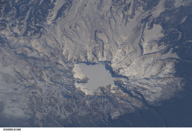
Features: BAITOUSHAN VOLCANO
Center Point Latitude: 42.0 Center Point Longitude: 128.0 (Negative numbers indicate south for latitude and west for longitude)
Stereo: (Yes indicates there is an adjacent picture of the same area)
ONC Map ID: JNC Map ID:
Camera
Camera Tilt: 27Camera Focal Length: 800mm
Camera: E4: Kodak DCS760C Electronic Still Camera
Film: 3060E : 3060 x 2036 pixel CCD, RGBG array.
Quality
Film Exposure:Percentage of Cloud Cover: 10 (0-10)
Nadir
Date: 20030404 (YYYYMMDD)GMT Time: 074020 (HHMMSS)Nadir Point Latitude: 40.8, Longitude: 126.8 (Negative numbers indicate south for latitude and west for longitude)
Nadir to Photo Center Direction: Northeast
Sun Azimuth: 255 (Clockwise angle in degrees from north to the sun measured at the nadir point)
Spacecraft Altitude: 204 nautical miles (378 km)
Sun Elevation Angle: 25 (Angle in degrees between the horizon and the sun, measured at the nadir point)
Orbit Number: 948
Captions
Baitoushan Volcano, China and North KoreaOne of the largest known eruptions of the modern geologic period (the Holocene) occurred at Baitoushan Volcano (also known as Changbaishan in China and P'aektu-san in Korea) about 1000 A.D., with erupted material deposited as far away as northern Japan—a distance of approximately 1,200 kilometers. The eruption also created the 4.5-kilometer-diameter, 850-meter-deep summit caldera of the volcano, which is now filled with the waters of Lake Tianchi (or Sky Lake). This oblique astronaut photograph was taken during the winter season, and snow highlights frozen Lake Tianchi and lava flow lobes along the southern face of the volcano.
Baitoushan last erupted in 1702, and geologists consider it to be dormant. Gas emissions were reported from the summit and nearby hot springs in 1994, but no evidence of renewed activity of the volcano was observed. The Chinese-Korean border runs directly through the center of the summit caldera, and the mountain is considered sacred by the predominantly Korean population living near the volcano. Lake Tianchi is a popular resort destination, both for its natural beauty and alleged sightings of unidentified creatures living in its depths (similar to the legendary Loch Ness Monster in Scotland).
Download Packaged File.
This option downloads the following items, packaged into a single file, if they are available:
- Browse image
- Cataloged information with captions
- Camera file
- Sound file
Server: 2 |
This service is provided by the International Space Station program. |
Recommended Citation: |
||

